Italian Archaeologists Are Using AI Robots to Piece Together the Past
The groundbreaking technology will be used to eliminate much of the labor-intensive steps in the process.
As the art world and AI continue to blend, so too have the efforts of archaeologists in unearthing the remnants of the old world. In Italy, experts are utilizing a new system called RePAIR, code named for “Reconstructing the Past: Artificial Intelligence and Robotics meet Cultural Heritage”, to help piece together ancient shards found across the country.
Funded by the European Union and launched in 2021, RePAIR works like a mechanical puzzle solver. In that, the machine is geared to “develop a ground-breaking technology to virtually eliminate one of the most labor-intensive and frustrating steps in archaeological research, namely the physical reconstruction of shattered artworks,” according to a release on the project’s website.
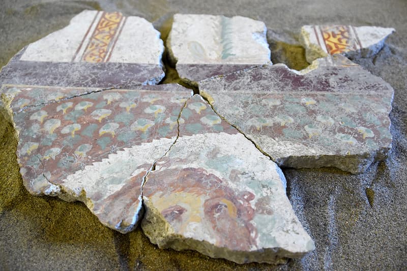
Amongst the tasks being worked on, RePAIR is reassemlbing a 2,000-year-old fresco from Pompeii. Destroyed by the eruption of Mount Vesuvius in 79 C.E. and subsequently preserved in volcanic ash, much of the villas, monuments and relics of Pompeii continue to fascinate historians millennia later — but the process of compiling individual shards can take years, many times with no success in the end.
The way it works is RePAIR scans each piece according to its size, shape and artwork, while the archaeologist can accomplish more complex tasks at hand. “Our goal is to let the archaeologist return from the excavation site in the evening, toss all the fragments on the table, and the next morning receive the complete vessel after the robot has put it together overnight,” said one of RePAIR’s founding scientists, Ohad Ben-Shahar, in an interview with Haaretz.
Like all forms of AI, technology is still far removed from any fantastical notions where humans would be removed altogether. As such, the machine will “present intermediate results to us as necessary, and will ask to consult with a human expert who will determine whether the result is good or whether the computer will have to be adjusted to help put it in the right direction,” Ben-Shahar affirmed. “People have always built machines to help them. In our project, autonomous machines will be helped by people.”
Archaeologists and Treasure Hunters should use this technology since the vast majority of the artifacts that they find are jumbled up in fragments. The restoration effort to put these artifacts together will provide a more complete story. They'll likely store them inside Museums, Universities, or return them to whomever it belongs to or repatriate them back.
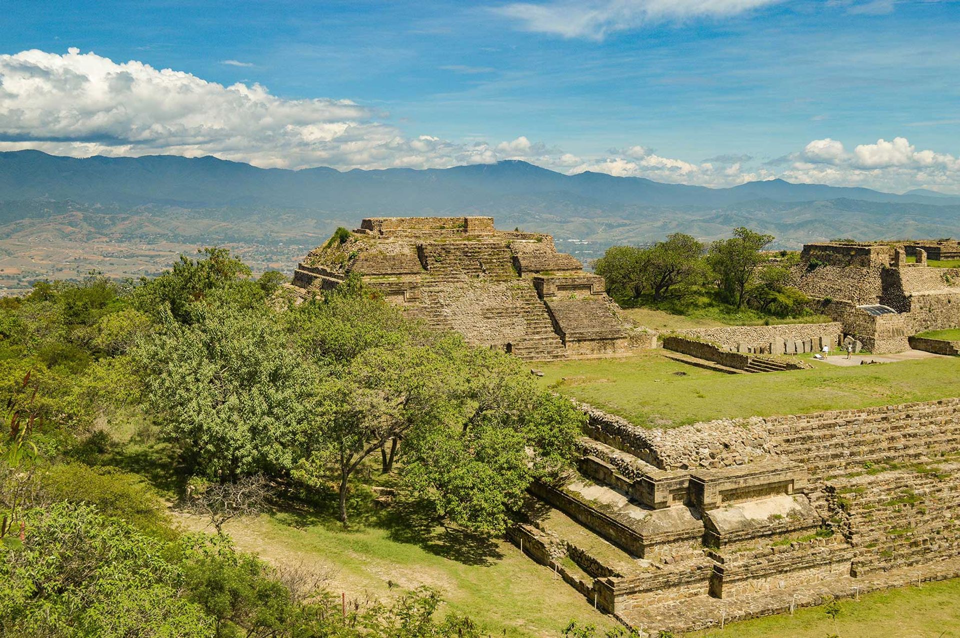
New museum planned for ancient Mayan complex Chichén Itzá, Mexico’s most visited archeological site
With first leg of controversial $20bn Maya Train project set to begin operation, authorities have stepped up excavation and development of archaeological destinations
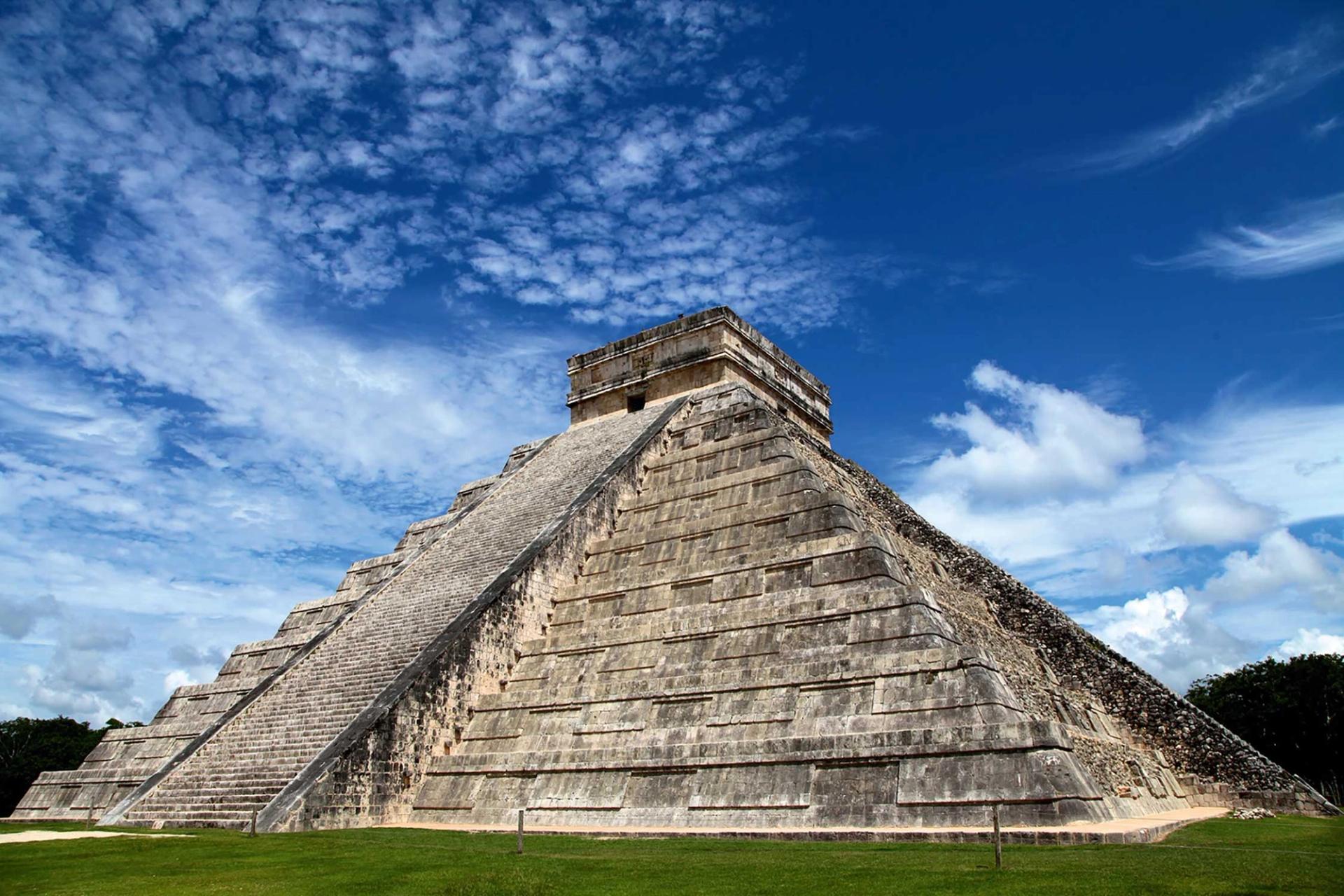
El Castillo, a pyramid devoted to the serpent deity K’uk’ulkan, is the star attraction at Chichén Itzá, Mexico’s most visited archaeological site. As the Maya Train project promoted by President Andrés Manuel López Obrador nears completion of its first branch, recently discovered artefacts are being restored and displayed, and a museum project is taking shape
Photo: Mario La Pergola/Unsplash
A new museum at Chichén Itzá, the ancient Mayan complex located in the north of Mexico’s Yucatán Peninsula, will showcase some of the region’s latest archaeological discoveries, including some found during excavation work for the controversial Tren Maya (Maya Train) project.
The museum, which is still in the planning stages, will replace a much smaller building that closed more than ten years ago. It is likely to follow in the museo de sitio (site museum) model found at other complexes managed by the federal Instituto Nacional de Antropologia e História (INAH), with a permanent display of items found during excavations at or near the vast site, which is best known as the location of the pyramid of the serpent deity K’uk’ulkan, one of the seven wonders of the modern world.
It is believed that construction of the first buildings at the site, including temples with carved limestone stelae, was begun by the Itzá between AD500 and AD600. Chichén Itzá is now Mexico’s most visited archeological site, with around two million visitors a year. Some scholars have expressed concerns that excessive tourism is putting the complex and the pyramid, known locally as El Castillo (the castle) and dating from AD800, at risk. Until a few years ago, visitors could climb to the top of the pyramid, but authorities no longer allow them to do so.
In 2010, after decades of wrangling, the Mexican government bought the site from a local family, the Barbachanos, who had owned the land since taking it over from the heirs of Edward Thompson (1856-1935), an amateur archaeologist who was the American consul in the city of Mérida. Thompson spent 30 years exploring the site and recovered many artefacts that he sent to the Peabody Museum at Harvard University in Cambridge, Massachusetts, during the late 1800s. The Mexico government later accused him of trafficking antiquities and expropriated a large part of the land, returning it to his descendants decades later.
Diego Prieto, the director of the INAH, gave very little information about the specifics of the forthcoming museum at Chichén Itzá, who would run it and what its cost would be. The INAH has previously said that around MX265m ($14.4m) would be set aside for work at Chichén Itzá that would include building the museum, a new visitor centre and the conservation of around 23 ancient buildings at the complex.
Carlos Esperón, the director of the Maya Museum in Cancún, in the neighbouring state of Quintana Roo, tells The Art Newspaper that work on the museum “could take two years”. Even after preliminary surveying of the site is complete, he says, the project will proceed slowly, because “all the groundwork will be done manually in order to minimise the risk to any undetected structures”.
He adds that “it is possible that some of the objects on display in the Maya Museum in Cancún” might be loaned or moved to Chichén. “We have some superb reproductions of the Pagautunes, mythical characters who were very important in Maya cosmology—the Maya believed they held up the sky up—which you can see in some of the temples at Chichén. It is possible they may go to the new museum.”
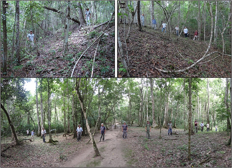
As the massive Maya Train project has taken shape, teams of archaeologists have been working against the clock at sites all across the Yucatán Peninsula, which is made up of five states: Campeche, Chiapas, Tabasco, Quintana Roo and Yucatán. The train will pass through all five states, with stations near several pre-Columbian sites as well as several airports.
The huge infrastructure project has become a focus for protest from some Indigenous groups, who say they were not fully consulted about the train route. Environmentalists have also voiced concerns over the loss of biodiversity and the potential damage to the region’s limestone landscape, which is known for its large number of cenotes (underground lakes) and cave systems—many of which were sacred to the Maya.
Photo: Unsplash
The INAH has made many discoveries during excavations along the train route, according to a spokesperson for the institute. To date they include the remnants of 2,568 buildings, 202 items of personal property or vestiges of clothing, 244 ceramic fragments and 38 caves or cenotes.
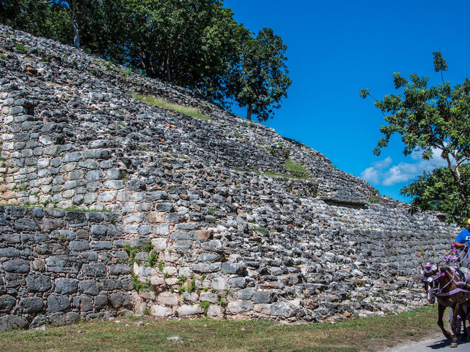
In addition to building a museum, the INAH recently announced it would be opening a part of the Chichén Itzá site known as Chichén Viejo, which was previously off limits to the public. The area includes two platforms, one of which has been recently named after the British archaeologist Alfred Maudslay (1850-1931), who photographed and made a number of plaster casts of reliefs at the site in the 1890s. Many of his casts and copies are held at the British Museum in London.
Maudslay’s great-nephew, Richard Maudslay, is the current chair of the British Mexican Society. “My great-uncle carried out a very detailed analysis of the glyphs and his photographs are used to this day,” he says. “It is most appropriate that his contribution to Mayan studies should be publicly recognised and I look forward to seeing the Maudslay platform on my next visit to the site.”
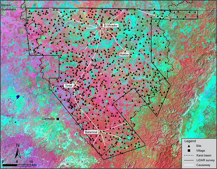
Using LiDAR technology, researchers located a new Maya site in northern Guatemala.
Causeways connect multiple settlements dated from roughly 1000 BC to 150 AD.
Known as the Mirador-Calakmul Karst Basin, more than 1,000 ancient Maya settlements and cities make up the area.
In a new study published in the journal Ancient Mesoamerica, researchers from Texas-based universities used LiDAR, or laser-based imaging, to open up more of Maya settlement history than ever known before.
The light detection and ranging technology pierced through the heavily forested Mirador-Calakmul Karst Basin in northern Guatemala to show that more than 1,000 settlements covered about 650 square miles, all connected with 110 miles of causeways that the Maya people used to travel their settlements, cities, and cultural centers. The researchers even located canals and reservoirs, highlighting the expanse of the organization from the Maya culture in the middle and late preclassic period from about 1000 BC to 150 AD.
It all amounted to a first look at "an area that was integrated politically and economically, and never seen before in other places in the Western Hemisphere," study co-author Carlos Morales-Aguilar, of the Department of Geography and the Environment at the University of Texas at Austin, tellsLive Science. "We can now see the entire landscape of the Maya region."
The concentration of preclassic Maya sites connected by causeways forms a "web of implied social, political, and economic interactions," according to the study:
"Monumental architecture, consistent architectural formats, specific site boundaries, water management/collection facilities, and 177 kilometers (110 miles) of elevated preclassic causeways suggest labor investments that defy organizational capabilities of lesser polities and potentially portray the strategies of governance in the preclassic period."
The study authors tell Live Science that for the Mayans, the area provided a mix of ideal living conditions for structures while still offering agricultural lowlands. Researchers believe that uncovering such a vast array of the Maya civilization shows off just how involved and interconnected the culture was.
"Settlement distributions, architectural continuities, chronological contemporaneity, and volumetric considerations of sites provide evidence for early centralized administrative and socio-economic strategies within a defined geographical region," the study says.
Mayan sites and causeways in the Mirador-Calakmul Karst Basin (MCKB). (Photo: Hansen et al.)
The ancient Maya of Central America created incredible civilizations. With their water filtration systems, mathematics, stone pyramids, and detailed calendars, the Maya dominated the region for hundreds of years. The Mayan Empire peaked in what is known as its classical period from 250 C.E. to 900 C.E. However, in the proceeding preclassical period from around 1800 B.C.E. to 250 C.E., the Maya were expanding and developing their settlements in the lowlands. Researchers recently published an analysis of one of these early civilizations, a 2,000-year-old network of 964 settlements connected by causeways.
The structures were discovered using LiDAR, a laser system that can scan through rainforests to discover hidden architecture. LiDAR can cover huge swaths of land; it has already been used to discover manyOlmec and Mayan settlementsin the dense forests of Central America. The recent study exposed more than 775 ancient Maya settlements within the Mirador-Calakmul Karst Basin (MCKB) region of Guatemala and 189 more in the surrounding karstic (limestone irregularity) ridge. Many of the settlements—independent architectural clusters—are connected by 110 miles of elevated dirt causeways. This interconnectivity implies the region's inhabitants had rich economic, political, and social ties.
The laser technology also revealed monumental architecture in many of the settlements. This includes platforms and pyramids which were used for ritual and entertainment purposes. Ball courts were also spotted, where inhabitants played regional versions of ball games. Reservoirs and canals indicate a sophisticated water delivery and storage system. The penultimate example of a preclassical Mayan city is El Mirador, an already-known settlement. Abandoned about 2,000 years ago, it was home to 200,000 people. Its enormous pyramids, platforms, and temples outshine later classical Mayan cities.
The LiDAR imaging of the region offers insight into what the authors of the recent paper call “the formation of a unified ‘kingdom' in the MCKB [which] may have emerged as smaller entities were absorbed into a larger hegemony, an alternative model to that proposed by Clark for the Middle Preclassic kingdoms of the Western Maya Highlands.” The connections between the settlements indicate a Mayan civilization even more advanced at an early date than previously known. While even more archeological revelations likely await discovery with LiDAR technology, the sheer scope and sophistication of ancient Mayan civilization is already awe-inspiring.
Researchers using LiDAR laser technology have discovered a complex ancient Mayan civilization in Northern Guatemala.
191w, 653w" />
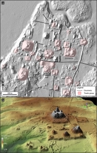
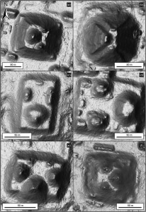
(a) LiDAR image showing triadic structures in the civic center of El Mirador (b) LiDAR 3D view showing the pyramidal complex of La Danta, located on the east side of the civic center at El Mirador.(Photo: Hansen et al.)
The civilization comprises about 1,000 towns spread across an area of around 650 square miles, connected by raised causeway roads.
206w, 704w" />
LiDAR images of selected triadic monumental structures. (Photo: Hansen et al.)
The civilization flourished around 2,000 years ago.
Could this site actually be related to Gunung Padang and Nan Madol?
Gunung Padang, Java, Indonesia
Nan Madol, Pohnpei
GARROBO GRANDE
This stone structure for example reminded me of the Pico Island structure located in the Azores, Portugal. The site also is similar in construction with the Guimar Pyramid located on the Tenerife Island which is the largest island of the Canary Islands that belongs to Spain. Another example is the Marae Structure in Tahiti, French Polynesia. Definitely there are several more similarities found throughout the world.
Pico Island Structure on Azores, Portugal
Guimar Structure on Tenerife, Canary Islands, Spain
Marae Structure on Tahitian Island, French Polynesia


 191w,
191w, 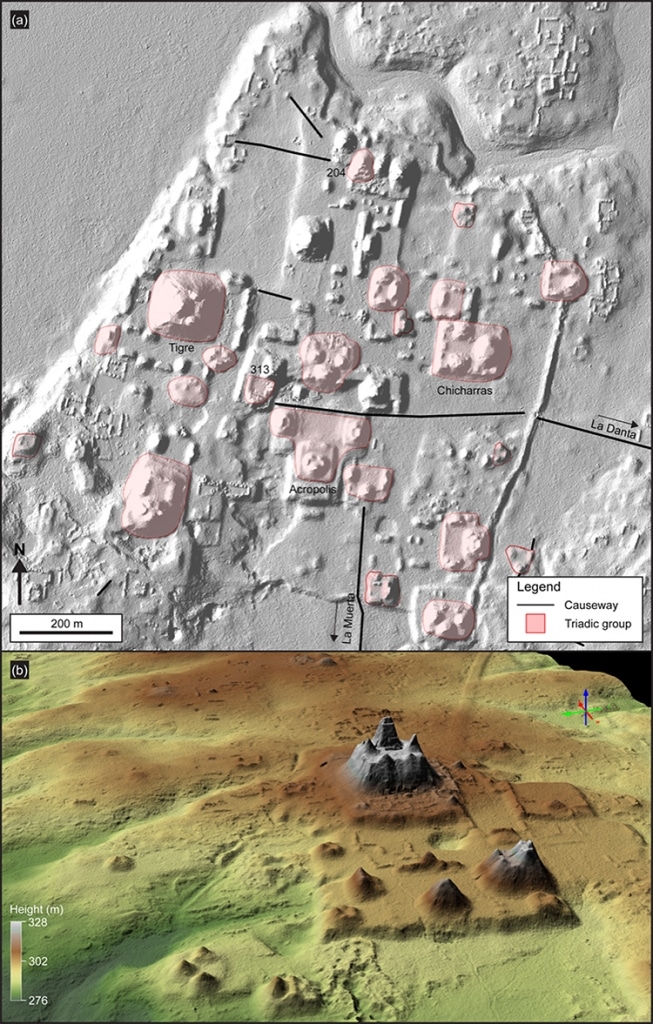

 206w,
206w, 
 300w" />


