It's preserved in a museum in Chicago. The chart is divided into 11 groups of stars, which depict the Skidi Pawnee constellations. The groups aren't in their correct positions in the sky, so the painting isn't intended as a sky chart. Instead, it is probably like a catalog — a reminder of the most important stars. Oct 30, 2018
I posted a topic on Pawnee Star Map on east bound forum under the topic 'Gunung Padang Megalithic Site, who built it?' in the spring season of 2017. I recently found some more pics and articles available online.
Pawnee Indians may actually have created more star maps because in general a well-produced star map is usually the final version suggesting that there were several older star maps that they produced that were probably less developed or less detailed prior to arriving to this final version.
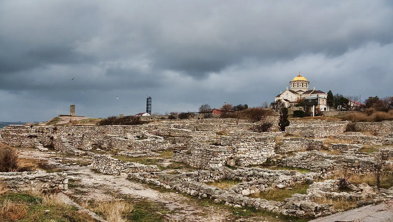
FRAGMENT OF GIANT ROMAN STATUE UNCOVERED IN CHERSONESOS
A TEAM OF ARCHAEOLOGISTS HAVE UNCOVERED A FRAGMENT BELONGING TO A 4-METRE-TALL STATUE DURING EXCAVATIONS ON THE WESTERN SIDE OF ST. VLADIMIR’S CATHEDRAL IN CHERSONESOS.
Chersonesos was founded as an ancient Greek colony by settlers from Heraclea Pontica during the 6thcentury BC on the outskirts of present-day Sevastopol in the Crimean Peninsula.
From the 1stcentury BC, the city was absorbed into the expanding Roman Republic, emerging as an important trading centre on the Black Sea.
The Byzantine Empire used Chersonesos for its strategic location to monitor the movements of barbarian tribes, and as a place of exile for notable figures such as Pope Clement I, Pope Martin I, and the deposed Byzantine Emperor Justinian II.
In a statement announced by the State Historical and Archaeological Museum-Reserve Tauric Chersonese in Sevastopol, archaeologists excavating on the south of the western entrance to the St. Vladimir’s Cathedral have uncovered a fragment of a marble sculpture that dates from the Roman period.
The fragment is part of a foot from a large statue, which the researchers suggest would have been around 4 metres in height and likely depicted a Roman emperor yet to be identified.
Daniil Kostromichev, said: “Presumably, this is a leg shod in a sandal made of leather belts. Usually such sandals are typical for the Roman army, but a figure of such a scale is most likely a statue of a Roman emperor from about the first centuries of our era.”
Excavations also revealed structures and burials that date from the medieval period around the 9thcentury AD, which the archaeologists hope will give new information to a little-known Christian church, which according to legend, was in the vicinity of where the baptism of Vladimir the Great took place in AD 988.
Header Image Credit : State Historical and Archaeological Museum-Reserve Tauric Chersonese
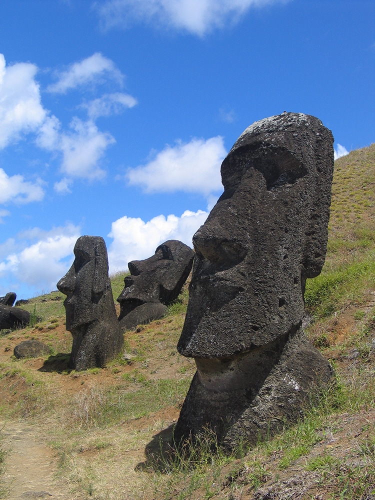
Moai at Rano Raraku, Easter Island. (Photo: Wikimedia Commons, Public domain)
Easter Island is known for its giant stone statues with stoic faces, known as moai. The small volcanic landmass in the Pacific Ocean is home to the indigenous Rapa Nui people, whose ancestors impressively crafted the moai. Ranging in size from three to 80 tons and towering up to 33 feet tall, the island's roughly 1,000 moai have long been an object of fascination around the world. Yet the story of the moai is still evolving: a new statue was discovered at the bottom of a dry lake bed. Exposed by climate change's effects, the new moai offers insight into what other hidden history the island may reveal.
The moai was discovered in a dried-up lake situated in a quarry on the island. It was long obscured by reeds, but receding water levels due to climate change exposed a glimpse of the stone. The find was announced by Salvador Atan Hito, the vice president of Ma'u Henua, the Indigenous organization that oversees the national park which stretches across much of the island. “For the Rapa Nui people, it's [a] very, very important discovery,” Hito told Good Morning America. “Because it's here in the lake and nobody knows this exists—even the ancestors, our grandparents don't know [about] that one.”
The find suggests more moai may be yet to be discovered. “The moai are important because they really represent the history of the Rapa Nui people,” Terry Hunt, professor of archeology at the University of Arizona, said. “They were the islanders' deified ancestors. They're iconic worldwide, and they really represent the fantastic archeological heritage of this island… We think we know all the moai, but then a new one turns up, a new discovery, and in this case, in the lake, at the statue quarry. There have been no moai found in the dry bed or in what was previously a lake, so this is a first.”
The Easter Island moai were carved between 1250 and 1500 CE. Some have been discovered to have buried stone “bodies.” Made of soft volcanic tuff, their faces gazed inland watching over their people. The moai were commissioned by individuals or groups and carved by teams working under master carvers. Transported on sleds, or with ropes and levers, the finished carvings eventually made their way to their posts watching over the island. European arrivals in the 18th century noted the moai, but by mid-19th century the statues had fallen. Restorations have restored many to their upright position. Future searches for new moai will also look for tools and writings to learn more about the “heads” and their fascinating history.
A new moai statue has been discovered at the bottom of a dry lake bed on Easter Island, a land famous for its stony-faced statues.
300w" />
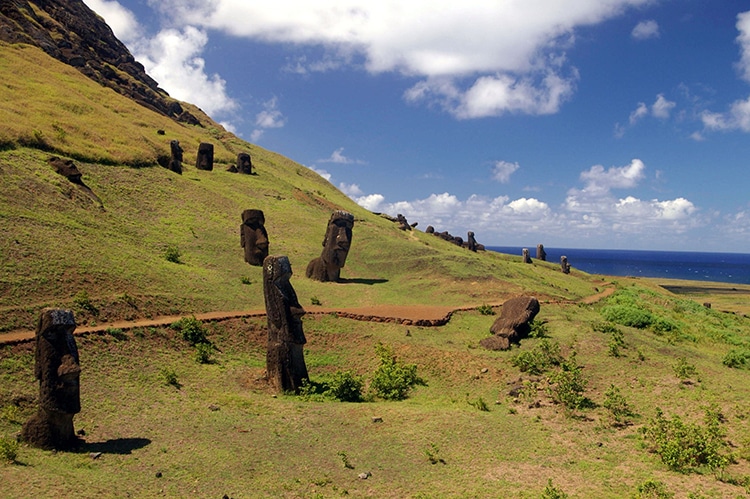
The outer slope of the Rano Raraku volcano, the quarry with many uncompleted statues. (Photo: Rivi Wikimedia Commons, CC BY-SA 3.0)
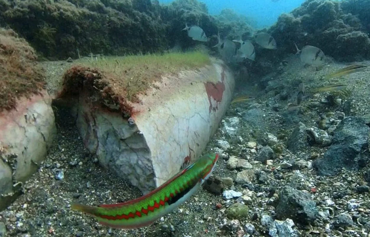
UNDERWATER SURVEY REVEALS NEW DISCOVERIES IN SUNKEN TOWN OF BAIA
SHARE
UNDERWATER ARCHAEOLOGISTS HAVE BEEN CONDUCTING ONGOING RESEARCH AT THE SUNKEN ROMAN TOWN OF BAIA, REVEALING NEW DISCOVERIES IN THE TERME DEL LACUS AREA.
Baiae is an archaeological park consisting of a partially sunken town from the Roman period, located on the shore of the Gulf of Naples in the present-day comune of Bacoli in Italy.
Baiae developed into a popular Roman resort which was visited frequently by many notable Roman figures, such as Gnaeus Pompeius Magnus (also known as Pompey the Great), Julius Caesar, Gaius Marius, Lucius Licinius Lucullus, Hadrian, and Septimius Severus.
The town would never attain a municipal status, but instead gained a reputation for a hedonistic lifestyle. This is supported by an account by Sextus Propertius, a poet of the Augustan age during the 1st century BC, who wrote that Baiae was a “vortex of luxury” and a “harbour of vice”.
Due to the position of the town on the Cumaean Peninsula in the Phlegraean Fields, an active and volatile volcanic region (which the Romans believed was the home of the Roman god of fire, Vulcan), local volcanic bradyseismic activity raised and lowered the geology on the peninsula that resulted in the lower parts of the town being submerged.
Underwater archaeologists from the Campi Flegrei Archaeological Park and Naumacos, have been conducting a survey of the Terme del Lacus area, revealing a block of structures covering 60 metres in length. The team also found stone colonnades, marble columns, and a portasanta marble column, which was imported during antiquity from the island of Chios in Greece.
A large piece of marble opus sectile flooring has also been identified, still rendered with portasanta and white marble in a chromatic alternating pattern. This currently appears as the most indicative dating element, being the typology and implementation referable to the Late Antiquity age.
Previous surveys of the area in 2013 uncovered an ornate statue representing Apollo, the Greek/Roman god of archery, music and dance, truth and prophecy, healing and diseases, the Sun and light, poetry, and more.
The rocky beach in Wrangell, Alaska, is decorated with more than 40 petroglyphs. Barry Winiker/Getty Images
Water laps gently against the rocky shores of Petroglyph Beach State Historic Site in Wrangell, an island town that’s part of Alaska’s Inside Passage, an archipelago that drips like a chain of pearls along the state’s southeast coast. I have to watch my footing as I amble along the beach, dodging thousands of craggy rocks that are beginning to poke up out of the sand.
It’s a sunny summer morning in late August, and the tide has already gone out for the day, exposing a rocky wonderland ripe for exploration. Unlike at most beaches, where people go to comb for seashells or sea glass, here I’m on the hunt for the dozens of petroglyphs that pepper the coastline’s boulders and bedrock. (The word petroglyph is derived from the Greek words petra and glyph, which translate to “rock” and “carving.”)
While there are numerous hypotheses about the origins of the more than 40 rock carvings etched here—one of the highest known concentrations of petroglyphs in Alaska and around the world—the one most often agreed upon by archaeologists is that they were etched roughly 8,000 years ago by the Tlingit (pronounced CLINK-it), an Alaska Native group that continues to inhabit the state’s southeastern archipelago. But when it comes to the petroglyphs’ intended purpose, that’s where things remain a mystery.
Visitors look at an interpretive display at Petroglyph Beach State Historic Park. Wolfgang Kaehler/LightRocket via Getty Images
According to a placard at the beach’s entry, the petroglyphs may have served any number of purposes, including being territorial markers to warn enemies that they were encroaching on settled land, a historical record commemorating a significant event such as a battle or an epic tidal wave that happened here, or underwater beacons to help coax salmon to swim to the mouths of the rivers and streams that feed into the Inside Passage straits. Others believe the drawings mark an important fishing site or settlement.
“These specific symbols are very unique to Southeastern Alaska,” says Nicholas Schmuck, a special projects archaeologist with the Alaska Department of Natural Resources. “Every time you get a good storm, they can become buried and then later exposed. They also come and go with the tides, causing them to disappear and reappear.”
The several-acre site officially became a state park in 2000. The petroglyphs are accessible via a wooden boardwalk that meanders down toward the rocky beach. On the surface, the site looks like any other beach in the area—especially when the tide is in, hiding the petroglyphs. But once the water retreats, searching for the drawings is much like an Easter egg hunt, with each artwork popping up when least expected. It’s possible there were once more than the 40 petroglyphs currently found at the beach, but tides over the centuries likely washed them away.
The best time to see the petroglyphs is at low tide, so I use the local tide tables provided by the National Oceanic and Atmospheric Administration as reference. Since my visit is during the summer, I aim to be at the beach earlier in the day.
It’s important to note that damaging or stealing the petroglyphs is considered a crime, and the artworks are protected under the Alaska Historic Preservation Act.
The petroglyphs are more vibrant when wet. Wolfgang Kaehler/LightRocket via Getty Images
The first carving I come across is a perfectly etched spiral, which immediately reminds me of the doodles I used to draw in the margins of my homework back in school. I pour some water from my water bottle onto the petroglyph to get a better look, since they appear more vibrant when wet. As I continue exploring the beach, I stumble upon a cluster of petroglyphs, including a cartoonish-looking face with two ginormous eyes, what appears to be a fish or whale replete with detailed fins and a bird that called to mind a flamingo perched on one foot.
I try to imagine what these ancient people were trying to communicate with their meticulously carved drawings. Did they know that thousands of years later this beach would become a popular tourist attraction? So much so that Wrangell commissioned Dick Stokes, a local Tlingit artist, to recreate some of the petroglyphs. Thanks to his recreations, visitors like myself can make rubbings using carbon paper without damaging the original pieces of artwork.
When I talk to Schmuck on the phone a few weeks after my visit, I ask him what his take is on the petroglyphs’ purpose and whether there are any clues that can help people like myself better understand their meaning.
“Wrangell is pretty exceptional when it comes to its abundance of petroglyphs,” Schmuck says. “If you look at [Tlingit] clan houses, they each have different crests. So, it’s possible that each of these petroglyphs are a different symbol for the clan.”
As an example, Schmuck mentions a drawing that I first thought was a fish but he says is more likely an orca (or killer whale), a common symbol used by the Tlingit on their meeting houses and totem poles.
A killer whale is a common symbol used by the Tlingit on their meeting houses and totem poles. Wolfgang Kaehler/LightRocket via Getty Images
“That one stands out because it was drawn in the Tlingit style,” he says. Also known as Northwest Coast art, this style of artwork contains curved thick and thin lines known as formlines. Ovoids (egg-like shapes), U forms and S forms often depict animals and people.
The Tlingit are accomplished carvers, evidenced by the many totem poles towering over the region. Like the totem poles, which often contain symbolic imagery depicted in family crests, the petroglyphs feature similar animals, such as killer whales, thunderbirds, salmon and ravens. Was it possible that a Tlingit artisan thousands of years ago was practicing their artistry by chiseling it into the beach rocks before applying their carving skills to an even bigger artwork?
It’s unlikely anyone will ever know the true intent of these petroglyphs, which simply adds to their mystery.


 300w" />
 492w,
492w, 


