From Wikipedia, the free encyclopedia
Diogo Ribeiro(d. 16 August 1533) was a Portuguesecartographerand explorer who worked most of his life in Spain where he was known asDiego Ribero. He worked on the official maps of thePadrón Real(orPadrón General) from 1518 to 1532. He also made navigation instruments, includingastrolabesandquadrants.[1]
Early life[edit]
Born as Diogo Ribeiro, he was the son of Afonso Ribeiro and Beatriz d’Oliveira.[1]However, there is no known record of the date and place of his birth. He is believed to have become a seaman at an early age and made several voyages toIndiaas a ship pilot. Reportedly, Ribeiro sailed with Pedro Afonso de Aguiar who served as captain in thearmadasof the explorersVasco da Gama(1502),Lopo Soares(1504), andAfonso de Albuquerque(1509).[1]
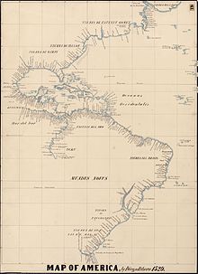
The Americas in Ribeiro's 1529 map
By 1516, Diogo Ribeiro and other several Portuguese navigators and cartographers, conflicting with KingManuel I of Portugal, gathered in Seville to serve the newly crownedCharles Vof Spain. Among them were explorers and cartographers Diogo andDuarte Barbosa,Estêvão Gomes,João Serrão,Ferdinand MagellanandJorge Reinel, cosmographers Francisco andRuy Faleiroand the Flemish merchantChristopher de Haro. Ribeiro started working for Charles I (and V of the Holy Roman Empire) in 1518, as a cartographer at theCasa de ContratacióninSeville.[2]Ferdinand Magellan took part in the development of the maps used in thefirst circumnavigation of the Earth.
On January 10, 1523, he was named Royal Cosmographer and "master in the art of creating maps, astrolabes, and other instruments". He eventually succeededSebastian Cabot(who left on a voyage) as the head cartographer. Cabot published his first map in 1544.
In 1524, Ribeiro participated in the Castilian (Spanish) delegation at theConference of Badajoz, where Castile (Spain) and Portugal discussed whether thePhilippineswere on the Castilian or Portuguese side of theTreaty of Tordesillas.
In 1527, Ribeiro finished thePadrón Real, the official (and secret) Spanish map used as template for the maps in all Spanish ships.[citation needed]
In 1531, he invented a bronze water pump that was able to pump water out ten times faster than the previous models.[citation needed]
Diogo Ribeiro died on 16 August 1533.[1]
World map[edit]
Ribeiro's most important work is the 1527Padrón Real. There are 6 copies attributed to Ribeiro,[3]including at theWeimarGrand Ducal Library (1527Mundus Novus) and at theVatican Library, inVatican City(1529Propaganda MaporCarta Universal).[3]The layout of the map (Mapamundi) is strongly influenced by the information obtained during the Magellan-Elcanotrip around the world.
Diogo's map delineates very precisely the coasts of Central and South America. It shows the whole east coast of the Americas but of the west coast only the area from Guatemala to Ecuador. However, neither Australia nor Antarctica appear, and theIndian subcontinentappears too small. The map shows, for the first time, the real extent of the Pacific Ocean. It also shows, for the first time in cartography, the North American coast as a continuous one (probably influenced byEstêvão Gomes's exploration in 1524/25). It also shows the demarcation of theTreaty of Tordesillas.


.jpeg)


