Tags
Tab Item Content
Join Us!
Archives Meta
Archaeology by Prau...
 
Notifications
Clear all

Archaeology [Sticky] Archaeology by Prau123

1,649 Posts
12 Users
27 Reactions
4.3 M Views
Prau123 avatar
Posts: 3145
Topic starter
(@prau123)
Famed Member
Joined: 6 years ago


Was Atlantis a Minoan Civilization on Santorini Island?


Satellite image of the island of Santorini, Greece
Was the story of Atlantis based on the Minoan civilization? And what is Atlantis’ connection to Santorini?. Credits: Samantha Cristoforetti/flickr/CC BY-NC-SA 2.0


Researchers have been speculating about the location or nature of Atlantis since Plato first wrote about it. A huge variety of theories have arisen, especially in modern times. Popular theories include identifying Atlantis with the Azores, Antarctica, or South America.

But one theory which has some respect among academics is that Atlantis could be connected to the Minoans. The Bronze Age Minoan civilisation bears some striking similarities to Plato’s description of Atlantis.

How the Minoan Civilization fits Atlantis

In his works called Timaeus and Critias, Plato presents a detailed description of Atlantis. He explains that it was a powerful civilization. The Atlanteans controlled one main island, several others, and parts of the continent.

How does this description compare to the Minoan civilization? Well, historians know that the Minoans ruled over Crete as their main island, but they also controlled several other islands in the Aegean Sea. They also seem to have had colonies on parts of the continent, such as in Anatolia and ancient Palestine.

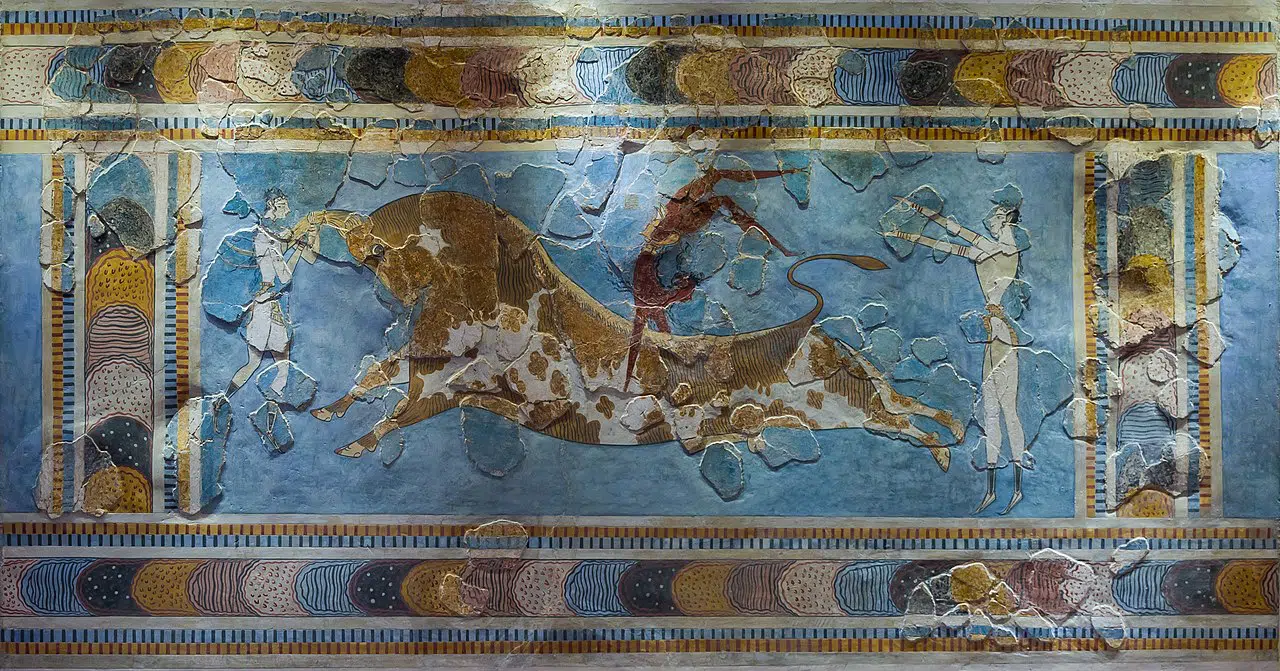
Also, Plato describes how the harbor of Atlantis was full of ships and merchants ‘coming from all parts’. In other words, it was a center of international trade. This matches perfectly with the Minoan civilization. They were the dominant trading force of their day. Minoan artefacts have been found all over the Mediterranean world for this reason.


Minoan Fresco 300w, 1024w, 768w, 150w, 600w, 696w, 1392w" data-lazy-sizes="(max-width: 1280px) 100vw, 1280px" data-lazy-src="https://greekreporter.com/wp-content/uploads/2021/07/Bull-leaping-minoan-fresco-Heraklion-gynmastics-credit-jebulon-cc0.jpg.webp" data-ll-status="loaded" />
A Minoan fresco from the 15th century BC. Credit: Jebulon / wikimedia commons / Public Domain

War Between Atlantis and Greece


One of the main features of the story of Atlantis is the fact that this island fought a war against Greece. The Atlanteans were the aggressors. Despite their immense power, the Greeks were able to defeat them.

This is an important detail which is often ignored in discussions of Atlantis. Historically, it is known that the Minoans really did fight a war with the Greeks (often called ‘Mycenaeans’ in this time period). And just like in the legend of Atlantis, the Greeks were victorious over the Minoans. We do not know who the aggressor in this historical war really was. However, we do know that later Greek legend presents King Minos of Crete as an aggressor against the Greeks.


The Connection Between Santorini and Atlantis


Santorini could be linked to Minoans and the lost Atlantis 300w, 150w, 600w, 696w, 1392w" data-lazy-sizes="(max-width: 640px) 100vw, 640px" data-lazy-src="https://greekreporter.com/wp-content/uploads/2022/10/Santorini_caldera_at_sundown_2600404573.jpg" data-ll-status="loaded" />
Credit: Bongo Vongo / CC-BY-SA-2.0 / Wikimedia Commons

In one part of Critias, Plato describes the metropolis of Atlantis. He explains that it was surrounded by alternating circles of land and sea, with a canal cut through from the outer sea to the central island. He mentions that there was a mountain in the center of the island ‘at a distance of about 50 stadia’. This implies that the center of the island was 50 stadia from the sea. Plato later confirms this by explaining that the canal from the sea to the central island was 50 stadia.

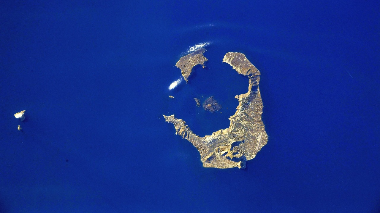
This would suggest that the diameter of the whole island was about 100 stadia, or approximately 11 miles. Interestingly, this is almost identical to the diameter of Santorini, which is about 10 miles. Santorini (or Thera, as it is also known) was one of the most important islands in the Minoan civilization, second only to Crete.


The Geography


At the moment, the circular archipelago of Santorini is composed of two central islands, one large island surrounding most of it, and a smaller island completing most of the remaining part of the circle. But in Minoan times, it was not so fragmented. There was a single central island, and then there was a large ring of land surrounding it in an almost complete circle. However, there was a narrow gap in this ring of land, which allowed passage to the sea from the central island.

This is very similar to how Plato describes the metropolis of Atlantis. He explains that in the centre there was a ‘small mountain’ or a ‘hill’, and that this was surrounded by two concentric rings of land. And as mentioned before, there was a wide canal cut through these rings of land to allow ships to pass through. Apart from the number of surrounding rings of land (Atlantis having two, with Santorini only having had one), this is a near-perfect description of Minoan Santorini.


Specific Features of Minoan Santorini and Atlantis


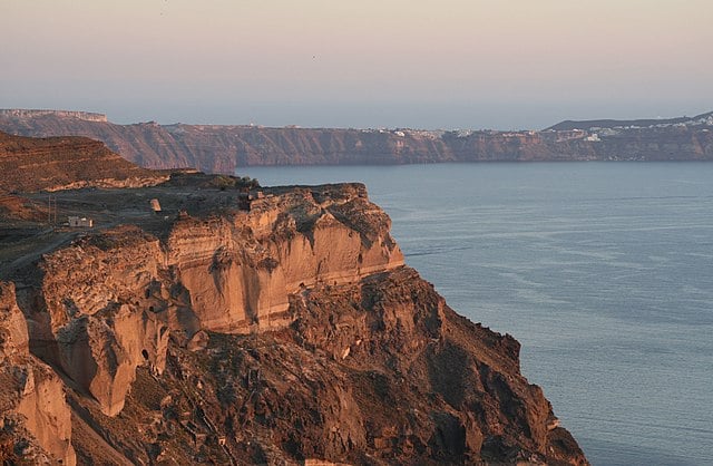
Various specific features mentioned by Plato match the Minoan civilization, particularly on Santorini. For example, he mentions that the construction work on Atlantis was done using rocks quarried from the island. Some rocks were red, some were white, and some were black. As it happens, rocks of these colors are abundant on Santorini, due to it being a volcanic island. Plato also claims that the Atlanteans made some of their buildings very colorful, which was certainly true of the Minoans.

Another detail Plato mentions is the fact that the Atlanteans made use of hot and cold water. He says that the hot and cold springs on the island were adapted for use, both for the kings and for the common people. He also mentions aqueducts transporting water across the island. The Minoans on Santorini and Crete are known to have had running hot and cold water, as well as impressive aqueducts.


How Santorini Explains the Destruction of Atlantis


Santorini minoans bronze age 300w" data-lazy-sizes="(max-width: 761px) 100vw, 761px" data-lazy-src="https://greekreporter.com/wp-content/uploads/2020/09/Archaeological-site-of-Akrotiri-Norbert-Nagel-Wikipedia-Commons.jpg" data-ll-status="loaded" />
The ruins of the Cycladic Bronze Age settlement on Santorini. Photo: Norbert Nagel / Wikipedia Commons.

One of the most striking parts of the story of Atlantis is the fact that it was supposed to have disappeared into the sea. Plato wrote:

“There occurred violent earthquakes and floods; and in a single day and night… the island of Atlantis… disappeared into the depths of the sea.”

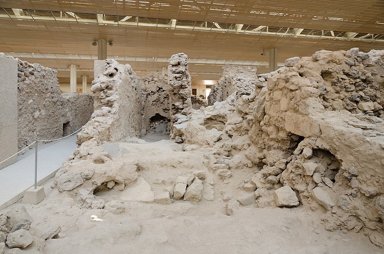
This description is easily explained by identifying Atlantis with the Minoan civilization on Santorini. In the 16th century BC (some outdated sources say 17th century BC), this volcanic island erupted. It was possibly the largest eruption in all of human history. It was so large that it literally blasted huge chunks of the island out into the sea.

But perhaps most significant was the fact that the eruption emptied the magma chamber beneath the island. This caused large sections of the island to literally collapse ‘into the depths of the sea’.


How Santorini May Be The Source Of The Atlantis Legend | Blowing Up History


See all the latest news from Greece and the world at Greekreporter.com. Contact our newsroom to report an update or send your story, photos and videos. Follow GR on Google News and subscribe here to our daily email!


Article


Was Atlantis a Minoan Civilization on Santorini Island? (greekreporter.com)


Video


(100) How Santorini May Be The Source Of The Atlantis Legend | Blowing Up History - YouTube


Reply
Prau123 avatar
Posts: 3145
Topic starter
(@prau123)
Famed Member
Joined: 6 years ago

What advantage(s) does the Roman numeral system have over the Hindu-Arabic numeral system?  


The Roman numeral system allowed for simple addition and subtraction. For addition, Romans simply lined up all of the numerals from the numbers being added, and simplified. For example, in order to solve the problem 7 + 22, or VII + XXII, the numerals were first arranged in descending order, or XXVIIII.


image


Who brought and popularized Hindu-Arabic numerals in Europe?
 
 
Leonardo Pisano
 
Leonardo Pisano, also known as Fibonacci, or son of Bonacci in Latin, was an Italian mathematician who brought the Hindu-Arabic numeral system to Europe, and more broadly, to the Western world.


Leonardo Pisano
 
We owe this to, among others, the Italian Leonardo Pisano (1170-1240), better known as Fibonacci. Originally from Tuscany, this mathematician brought Hindu-Arabic numerals to Europe in the 13th century. He had come across the system in North Africa, where he had travelled with his father, Guglielmo Bonacci, a notary.


What did Fibonacci introduce to Europe?


Fibonacci popularized the Indo–Arabic numeral system in the Western world primarily through his composition in 1202 of Liber Abaci (Book of Calculation) and also introduced Europe to the sequence of Fibonacci numbers, which he used as an example in Liber Abaci.


When were Hindu-Arabic numerals first used in England?
 
 
The Hindu-Arabic numeral system only came into use throughout Europe in the 1200s after Italian mathematician Leonardo of Pisa (nicknamed Fibonacci) helped spread it through his work (now known as the Fibonacci sequence of numbers). Hindu-Arabic numerals were adopted in England during the 15th century.


When did Hindu-Arabic numerals become popular?


Europeans learned of Hindu-Arabic numerals about the 10th century, though their spread was a gradual process (in Spain).
 
Two centuries later, in the Algerian city of Béjaïa, the Italian scholar Fibonacci first encountered the numerals; his work was crucial in making them known throughout Europe.


Who invented Hindu Arabic numerals?
 
It was invented between the 1st and 4th centuries by Indian mathematicians


Reply
Prau123 avatar
Posts: 3145
Topic starter
(@prau123)
Famed Member
Joined: 6 years ago


‘Over 90% of India’s heritage lies buried and space archaeology can help unearth it … using satellites as a tool’


February 10, 2020, 8:31 AM IST 
 
 
Manimugdha S Sharma
Manimugdha S Sharma

American archaeologist and Egyptologist Sarah Parcak, who teaches at the University of Alabama, is a new age Indiana Jones harnessing the power of satellites to discover archaeological sites. She has now tied up with Archaeological Survey of India (ASI) to use remote sensing to map archaeological sites. Manimugdha S Sharma picks her brain:

What is space archaeology?

It’s a term that describes how archaeologists use diverse remote sensing datasets – from lasers to space-based imaging systems – to map partially to totally invisible ancient features, from small walls to entire cities. Other terms are ‘satellite archaeology’, ‘satellite remote sensing’. You become an archaeologist first.

Why is it needed in India?

India has such an extraordinary and rich heritage, with many thousands of years of occupation. There have been archaeologists using satellites already in India, proving their effectiveness in site detection. They allow sites to be detected rapidly and over large areas, which is an advantage as India’s landscapes are varied and massive. With so many archaeological sites likely to be detected from space, satellites will allow archaeologists to gain an accurate count of sites across India and the modern threats to them, and hopefully some exciting new discoveries.

What’s your project in India about?

We will be launching our free citizen archaeology platform in India later this year. This online platform allows anyone to look at satellite imagery and help us map potential cultural heritage, starting in Gujarat and over time, expanding across India. The data will be shared with ASI without GPS location so that site locations will be protected. We’ll also be offering satellite remote sensing training for ASI and archaeology students at Indian universities, with the goal of training a new generation of archaeologists in advanced mapping. We also hope to work together with ASI to develop new sites for tourism.

What sort of hurdles do space archaeologists face on the ground?

Satellites are among a number of tools available to help archaeologists gain a better understanding of the landscapes around the sites where they work, and a way for them to discover features on sites or even entire sites in time- and cost-efficient ways. Using satellites is a tool, not the means to an end. We ultimately have to do good excavation and survey on the ground, with all the associated hurdles: challenges with limited time, funding, or any restrictions we face.

Is there a risk of false positives in analyzing satellite data?

Many satellite sensors capture light reflected off the earth’s surface, recorded in the visible through infrared parts of the light spectrum. Scientists can order and download the satellite data either for free from NASA or from commercial companies for high resolution data. They then process it using off-the-shelf software, using differences in the vegetation, soil, or water content in the imagery to make subtle to otherwise invisible features appear – from small walls or roads to relic river courses or monumental structures. Like any science, there can be false positives – usually about 10% of the time is standard.

Roughly, how much of India’s heritage lies buried?

It is very hard to predict how much of our past is buried. But I do feel confident saying more than 90% of most archaeological sites have not been excavated, and there are millions of archaeological sites across the globe that need to be found. Thus, I would estimate that more than 90% of India’s heritage is buried, the same percentage I would give for any country that contains significant archaeological sites. Several Indus Valley Civilization sites have suffered artefact loot.

Can your work stop this?

A government cannot protect all the cultural assets within the boundaries of their country without first knowing where they are. Thus, step one is mapping sites, and understanding the potential threats to them from urbanization, looting, general development, or climate change. The problems are bigger than just looting, and these issues are global. Governments can then prioritize which sites to safeguard or develop for tourism. We will share all the threats we find to India’s heritage sites with ASI and appropriate government authorities. This is about developing good systems of detection first, and then strategizing approaches to work with local communities closest to the threatened sites.

Your project is also a citizen oriented venture. How does the common man get involved?

There’s just no way that archaeologists alone can map and locate all the archaeological features. Globalexplorer or GX, is a not-for-profit, focused on using innovative technologies to empower the world to help map and protect its collective global heritage. The website we run is an online citizen science satellite archaeology platform that allows anyone in the world, aged 5-105, to look at satellite imagery and help us find sites. All the data will be shared with professional archaeologists at the ASI as well as academic specialists. Our goal is to map the world in the next 10 years.


Article


https://timesofindia.indiatimes.com/blogs/parthian-shot/over-90-of-indias-heritage-lies-buried-and-space-archaeology-can-help-unearth-it-using-satellites-is-a-tool/


Reply
Prau123 avatar
Posts: 3145
Topic starter
(@prau123)
Famed Member
Joined: 6 years ago


NASA’s New ‘Voyager’: 7 Things To Know About The 50-Year ‘Interstellar Probe’ Mission To Burst Our Cosmic Bubble


Apr 27, 2021,06:00pm EDT
 

This article is more than 2 years old.


Scientists hope the proposed Interstellar Probe will teach us more about our home in the galaxy as well as how other stars in the galaxy interact with their interstellar neighbourhoods.

JOHNS HOPKINS APL


On February 14, 1990, NASA’s Voyager 1 space probe turned its cameras back towards the Sun and took a hazy, fuzzy and not particularly useful image that included our planet as a “a mote of dust suspended in a sunbeam.” 


The late popular astronomer Carl Sagan, who wrote those words about the now https://www.planetary.org/worlds/pale-blue-do t" aria-label="iconic “Pale Blue Dot” photo">iconic “Pale Blue Dot” photo (below) would today surely be working on the “Interstellar Probe,” a new mission concept to boldly go where no spacecraft has gone before.


Being https://meetingorganizer.copernicus.org/EGU21/EGU21-10504.htm l" aria-label="discussed">discussed this week at the European Geoscience Union General Assembly 2021, scientists are planning for the http://interstellarprobe.jhuapl.edu /" aria-label="Interstellar Probe">Interstellar Probe to reach the “interstellar medium”—the space beyond our Solar System—that’s about 10 times as far as the Voyager spacecraft have gone.

In doing so it will find out the nature of the “cosmic bubble” that envelopes the Sun, in which the Solar System exists, but it could also uncover a few new worlds on its way.


Here are seven things you need to know about this groundbreaking 50-year mission:


This image of Earth is one of 60 frames taken by the Voyager 1 spacecraft on February 14, 1990 from a distance of more than 6 billion kilometers (4 billion miles) and about 32 degrees above the ecliptic plane. In the image the Earth is a mere point of light, a crescent only 0.12 pixel in size. Our planet was caught in the center of one of the scattered light rays resulting from taking the image so close to the Sun. This image is part of Voyager 1's final photographic assignment which captured family portraits of the Sun and planets.

NASA / JPL


1. It will update our ‘Pale Blue Dot’ photo

“The Interstellar Probe will go to the unknown local interstellar space, where humanity has never reached before,” said Elena Provornikova, the Interstellar Probe heliophysics lead from the Johns Hopkins Applied Physics Lab (APL) in Maryland.

“For the first time, we will take a picture of our vast heliosphere from the outside to see what our Solar System home looks like.”


2. It would be our boldest move since the Moon landings

That’s according to the scientists behind the concept, who say that this first deliberate step into the sea of space between our Sun and other potentially habitable systems would lead to new and inspiring exploration.

The project is being led by the Johns Hopkins University Applied Physics Laboratory (APL), but the concept study now underway is being funded by NASA. It’s largely based on current technology.


An artist concept depicting one of NASA's twin Voyager spacecraft. Humanity's farthest and longest-lived spacecraft are celebrating 40 years in August and September 2017.

NASA/JPL-CALTECH


3. It will go about 10 times as far as the Voyager spacecraft

Voyager 1 and Voyager 2 spacecraft entered interstellar space in 2012 and 2018, respectively. They’ve traveled about 120 astronomical units (au)—120 times the distance from the Earth to the Sun—and are at the boundary of the heliosphere, the Sun’s sphere of influence.

The Interstellar Probe will reach 1,000 AU and enter the https://en.wikipedia.org/wiki/Interstellar_mediu m" aria-label="interstellar medium">interstellar medium—the space between the stars.


4. It could launch in 2030 and last for over 50 years

Slated to launch in the early 2030s, Interstellar Probe would take about 15 years to reach the heliosphere boundary. That’s super-quick. After all, the two Voyager spacecraft took 35 years to reach the same place. The lifespan of this Interstellar Probe is rated at 50 years, which would give it 35 years—and likely much longer—to explore a totally new region of space.

A key recent innovation that makes this possible is NASA’s SLS heavy-lift rocket, which could get the Interstellar Probe to the velocity necessary—and allow it to cover about seven au per year.


Scientists plan for the Interstellar Probe to reach 1,000 AU — 1 AU is the distance from the sun to Earth — into the interstellar medium. That’s about 10 times as far as the Voyager spacecraft have gone.

JOHNS HOPKINS APL


5. It will explore our ‘shield’ from the outside

The heliosphere is the extent of the Sun’s influence. It’s the limit of the solar wind—that stream of charged particles that the Sun throws out into space—but it also shields our Solar System from high-energy galactic cosmic rays. Science instruments on the Interstellar Probe will find out:


  • How the Sun’s plasma interacts with interstellar gas to create our heliosphere.
  • What lies beyond the heliosphere
  • What our heliosphere even looks like from the outside.


It will use energetic neutral atoms to take images of the heliosphere and could even detect extragalactic background light from the early times of our galaxy’s formation.


6. It could fly-by a dwarf planet we know nothing about

Forget the “eight planets” thing. Sure, Pluto got relegated to dwarf planet status, but the real story was always this: the Solar System has a ton of small planets. Beyond Pluto there are reckoned to be about 130 dwarf planets, but as we know from exploring Pluto (which turned out to be geologically active and may have an underground ocean of liquid water), many are they’re way more geologically complex and interesting than we thought.

So on its way out to deep space the Interstellar Probe could swing by either https://en.wikipedia.org/wiki/50000_Quaoa r" aria-label="Quaoar">Quaoar or https://en.wikipedia.org/wiki/225088_Gonggon g" aria-label="Gonggong">Gonggong—which could be geologically active—plus another dwarf planet.


Our solar journey through space is carrying us through a cluster of very low density interstellar clouds. Right now the Sun is inside of a cloud (Local cloud) that is so tenuous that the interstellar gas detected by IBEX is as sparse as a handful of air stretched over a column that is hundreds of light years long. These clouds are identified by their motions, indicated in this graphic with blue arrows.

NASA/GODDARD/ADLER/U. CHICAGO/WESLEYAN


7. It will recce the next region of space we’re about to enter

That shield around our Solar System may be about to get swamped. The Sun orbits the center of the Milky Way galaxy about once every 220-250 million years. That’s a galactic year, which makes the Earth about 16 years old. Scientists think that the Sun is currently on the edge of the Local Interstellar Cloud, having spent millions of years traveling through it, and will soon move into a new region of interstellar space.

So the Interstellar Probe will see what’s coming next, and whether the Sun’s heliosphere adjusts to a changing level of galactic cosmic rays in this new region of space. If there are more, it could raise the level of background radiation level at Earth. As a bonus scientists will also discover how out Sun, and by extension, all stars, interacts with the local galaxy.

At the end of 2021 the team will deliver a report to NASA that outlines potential science, example instrument payloads, and example spacecraft and trajectory designs for the mission. “Our approach is to lay out the menu of what can be done in such a space mission,” said Provornikova.

Wishing you clear skies and wide eyes.


Article


https://www.forbes.com/sites/jamiecartereurope/2021/04/27/nasas-new-voyager-7-things-to-know-about-the-50-year-interstellar-probe-mission-to-burst-our-cosmic-bubble/?sh=476539bd6279


Were Voyager 1 and 2 launched together?


The twin spacecraft Voyager 1 and Voyager 2 were launched by NASA in separate months in the summer of 1977 from Cape Canaveral, Florida.


Are Voyager 1 and 2 still transmitting?


As of 2023, the Voyagers are still in operation beyond the outer boundary of the heliosphere in interstellar space. They collect and transmit useful data to Earth.


Will Voyager 3 satellite include a remote sensing technology that's capable of acquiring information from a distance on Earth as well as on other planets and moons?  Since Voyager 3 is sweeping through our solar system and beyond, then it should have an instrument capable of doing some remote sensing on rocky planets and moons.  Probably Voyager 3 will be the first Voyager space satellite capable of doing this remarkable mission.  Hopefully Voyager 3 satellite participates in Space Archaeology since it is the only upcoming space satellite to be launch in the next decade that is expected to travel beyond our solar system which give itself a rare opportunity to acquire valuable information on several unknown planets and moons beyond our eighth planet. NASA should consider launching 2 or 3 Voyager space satellites in 2030 since it will take awhile for the planets to be realigned again allowing the Voyager space satellites to swing around the planets.


Voyager 1 and 2 were designed to take advantage of a rare planetary alignment to study the outer solar system up close. Voyager 2 targeted Jupiter, Saturn, Uranus and Neptune. Like its sister spacecraft, Voyager 2 also was designed to find and study the edge of our solar system.


image


Reply
Prau123 avatar
Posts: 3145
Topic starter
(@prau123)
Famed Member
Joined: 6 years ago


Australian Aborigines


Aboriginal Tradition Could Prevent Bushfires in Australia


Australian Aboriginal people have used fire to stop wildfires for thousands of years. Many see it as a solution for the devastating blazes that have ravaged the country. In Queensland, the Indigenous organization Firesticks is hosting workshops for people from across the country to spread that knowledge.


Video


Could Aboriginal Burns Save Australia From Fires?


Video


image


image


image


image


Reply
Page 122 / 317