The mystery behind this cave is an enigma of ancient structures that were built here long ago. I voyaged to Naupa Iglesia (Naupa Huaca) and investigated the cave. It has this strange andesite stone structure infront of the cave overlooking the valley. It also has this mysterious false door or alter that is cut onto the side of the cave. But in the back of the cave, it's blocked off by piles of stone. Who do you think built this place, and why? Also, what do you think is in the back of this ancient cave? This expedition was guided by Helder from @megalithicevidence. Thank you Helder for the help with measuring and this amazing voyage to Naupa Iglesia.
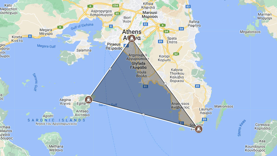
300w, 1024w, 768w, 150w, 600w, 696w, 1392w" data-lazy-sizes="(max-width: 1127px) 100vw, 1127px" data-lazy-src="https://greekreporter.com/wp-content/uploads/2023/12/Sacred-triangle-parthenon-sounio-aphaia-googlemaps-greekreporter-illustration.png" data-ll-status="loaded" />Sacred geometry found in ancient Greek temples is grounded on the idea that the world is created based on a consistent geometrical pattern. Credit: Google Maps / GreekReporter Illustration
Sacred geometry is a concept developed in ancient times grounded on the idea that the world is created based on a consistent geometrical pattern. This “mysterious” geometry can be found in ancient Greek temples all over Greece. The concept ascribes symbolic and sacred meanings to certain geometric shapes and geometric proportions associated with the belief of an orderly universe.
Sacred geometry triangles ‘Connecting’ ancient Greek temples
In 1938, World Renowned architect Doxiades discovered that the monuments and altars were not randomly placed or constructed, there was a pattern. In 1967, French researcher Jean Richer, wrote the book Sacred Geography of the Ancient Greeks, in which he analyzes those connections.
In his book, Richer claims that if linear lines were drawn from altar to altar, they would mirror constellations along with Zodiac cycles. In fact, Richer argues that many of the patron animals of these ancient Greek cities were correlated to the locations of constellations that often included mythological attributions.
Furthemore, in the 1950s, an unknown scientist stated that the distances between the three temples of Sounion, Aphaia, and the Parthenon created a perfect isosceles triangle.
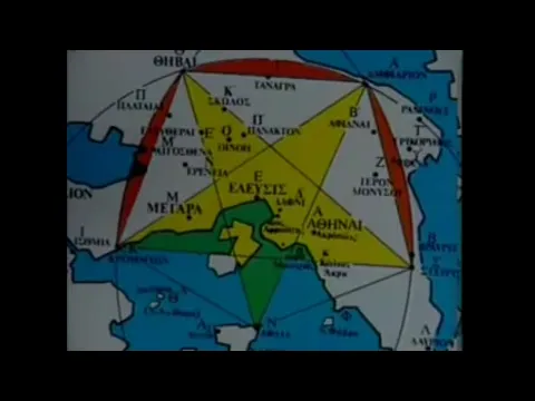
If a circle was constructed with the Parthenon as the center and a radius line the distance to Thision, it would be found that the circumference of this circle passes by three main ponts. The orator’s step of Pnyx, the monument of Filopapou, and the temple of Olympian Zeus. Even more interestingly, the radius of this circle is equal to 2,058 ft, or 300 times the golden ratio. Another interesting fact is that the center of the temple of Olympian Zeus lies equidistant with Hephaestion and the step of the rhetors at Pnyx.
Researches can also find the five-edged star of the Pythagoreans. The star falls with these five locations, Thebes, Cromion, Aphaia, Stiris, and Amfiaron. Thus, proving the geometric harmony of these locations as well as their purposeful arrangement.
According to Greek historian Herodotus (c. 484-425 BC), geometry was established as a science by the ancient Egyptians. There is written evidence of this in Egypt. The ancient Mesopotamians are also known to have practiced geometry, as did early Chinese and Indians. The Greek name for this branch of mathematics is derived from the words ‘geo’ (Earth) and ‘metron’ (measure), literally meaning “measuring the world.”
The ancient Greek mathematician Euclid is considered the father of geometry. His treatise on geometry, The Elements, is one of the most influential works in the history of mathematics. Euclid’s work is a prime example of the rational and academic approach to the study of geometry. Other geometers and thinkers, however, saw symbolic and sacred meanings in geometry, and, therefore, their field of study may be referred to as sacred geometry.
A group of these thinkers were the Pythagoreans, whose school of philosophy was founded by Pythagoras of Samos.
Pythagoreans and the tetractys
The first symbol in sacred geometry originates from the Pythagoreans and is called the tetractys, or the tetractys of the decad (tetractys meaning “four” and decad meaning “ten”). This symbol consists of ten dots arranged in four rows, thus forming an equilateral triangle. The tetractys is full of symbolic meaning. For example, each row of dots is said to contain a hidden meaning.
The first row, which has a single dot, represents the active principle, or divine power behind all creation. The second represents the passive principle, or matter, while the third refers to the world proceeding from the union of the active and passive principles. The fourth is associated to the four liberal arts and sciences of which the world is composed.
300w, 768w, 150w, 600w, 696w, 1392w, 1280w" data-lazy-sizes="(max-width: 696px) 100vw, 696px" data-lazy-src="https://greekreporter.com/wp-content/uploads/2023/12/Tetractys_credit_Jossifresco_Public_Domain-1024x858.png" data-ll-status="loaded" />The sacred geometry tetractys triangle created by the Pythagorean school by Jossifresco. Public Domain.
The Pythagoreans were not the only ancient Greeks who delved in sacred geometry. Overall, it was a philosophical idea that the world shared a symbolic pattern of shapes that ceaselessly manifest in nature, including plants, animals, the human body, and generally across the entire universe.
Plato and his academy studied geometry mainly for these philosophical purposes, and mathematics itself was to provide a map of the human psyche. At the entrance to Plato’s Academy, there is an inscription meaning “let no one ignorant of geometry come under my roof” (Greek: “Mηδείς ἀγεωμέτρητος εἰσίτω μου τὴν στέγην”).
This study of the philosophical value inherent in the basics of geometry was considered sacred and became a universal language mainly among philosophers.
The circle in sacred geometry
Apart from the triangle, found in the sacred geometry of ancient Greek temples, many other shapes have been imbued with symbolic meaning. Greeks perceived the circle as a symbol of unity, oneness, and indivisibility. The circle is almost universally employed as a symbol for the Sun. It may be repeated in order to create new symbols, such as circles within larger circles or intertwining ones.
Aristotle wrote in Physics that the circle is “the perfect, first, most beautiful form.” In both geometry and sacred geometry, the circle is considered to be the most essential shape, as it symbolizes unity in both the two and three dimensional. Earth is a sphere as are the other planets, moons, stars, galaxies, and most fundamental forms of life such as atoms, molecules, seeds, and eggs.
The circle also represents the cycles of life and is therefore connected to growth and movement. Cyclical movement patterns are essential to life and can be observed between all the planets circling around the sun, the moons revolving around the planets, and the planets spinning on their axis, leading to further cycles of days, months, and years.
Searching for the Golden Ratio
The Golden Ratio is crucial to sacred geometry. It is known by many other names, including phi (the Greek Φ), the divine proportion, and the golden mean. Ιn Euclid’s Elements, you find one of the first recorded definitions of this golden ratio: “A straight line is said to have been cut into extreme and mean ratio when, as the whole line is to the greater segment, so is the greater to the lesser.”
In simpler terms, the Golden Ratio refers to a perfectly symmetrical relationship between two proportions by which the relationship between the larger and smaller parts is the same as that between the whole and the larger parts.
The mathematics of the Golden Ratio proportion is generated by the formula (√5+1/2) (or 1:1.618). Τhe ancient Greeks found that the Golden Ratio provided “the most aesthetically pleasing proportion of sides of a rectangle.” They are alleged to have applied it in their architecture. This ratio is renowned for producing some of the most aesthetic shapes.
According to the great Athenian philosopher Plato in his dialogue Timaeus, the Earth is composed of four basic elements—fire, air, water, and earth.
The Platonic solids are five three-dimensional shapes essential to sacred geometry. These are the tetrahedron, hexahedron (or cube), octahedron, dodecahedron, and icosahedron, which have four, six, eight, twelve, and twenty sides, respectively.
Plato associated his solids with the four basic elements. The tetrahedron represented fire, due to its sharp points and edge, whereas the hexahedron was linked with earth, due to its four-square regularity. The octahedron and icosahedron, both of which are made up of triangles, represent air and water, respectively.
Lastly, the dodecahedron was assigned by Plato to the heavens, as its twelve pentagonal faces corresponded with the twelve constellations. Using these five solids, Plato created a theory of the universe. Plato’s theory was based on the symbolic properties of the five solids, and mathematicians were less interested in them.
However, his theory was revived during the sixteenth century by the German astronomer Johannes Kepler. Since then, the Platonic solids have made their way into sacred geometry and acquired additional symbolic value.
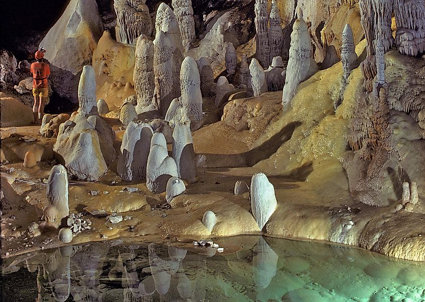
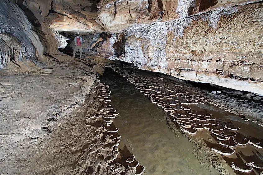
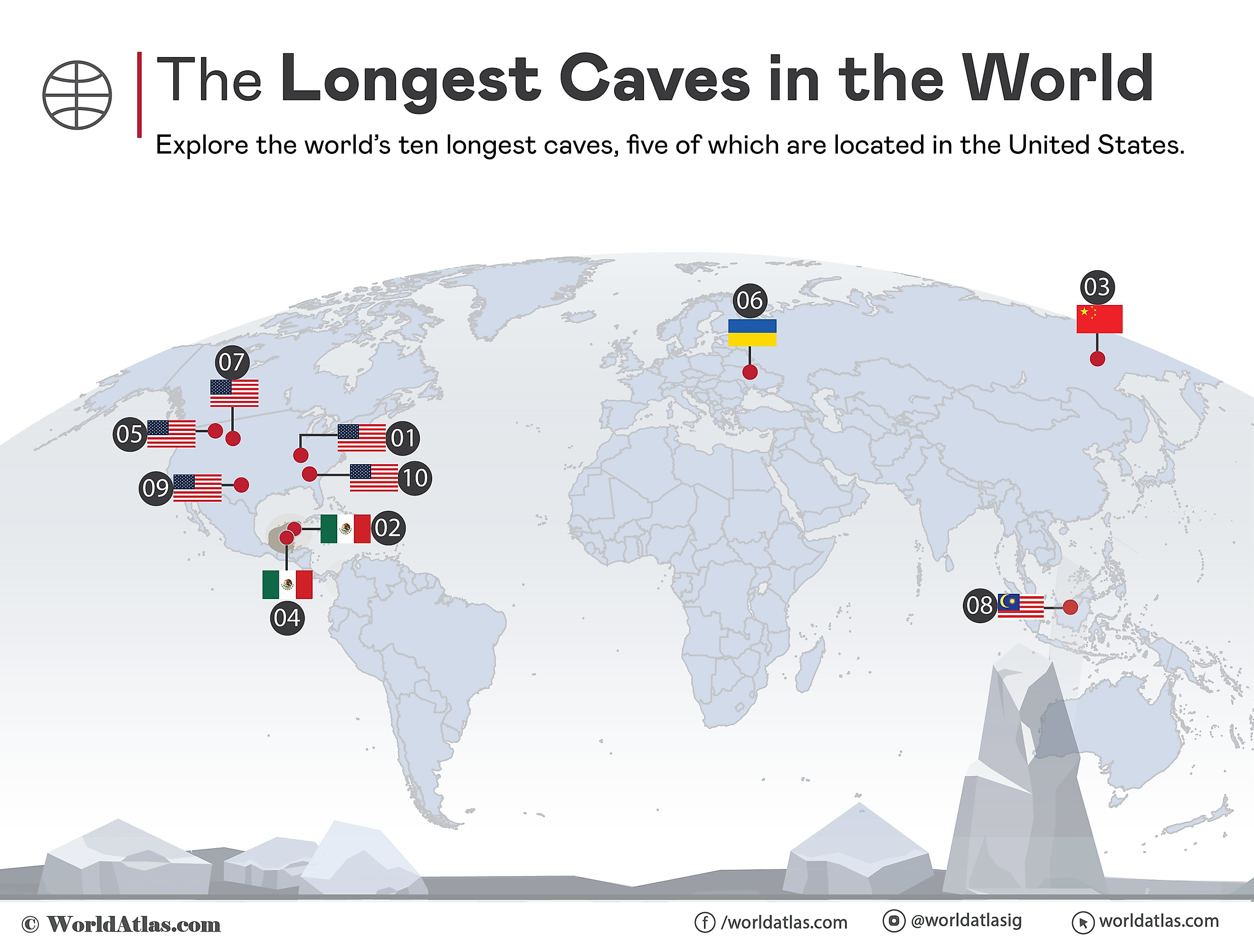
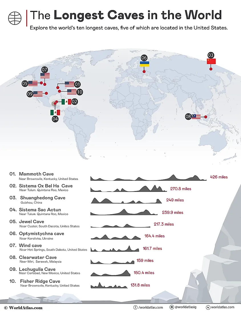
A cave or cavern refers to a natural opening on theEarth’ssurface that extends beyond the light zone and has a height and width that allows at least a single person to enter by crawling. Ranging widely in size, caves are formed by varied geological processes, and depending on their location and mode of formation, they are classified intodifferent types. The longest caves in the world are found in areas withkarstlandforms whose rocks dissolve quickly. The highest number of such long caves are seen in southernKentucky’sPennyroyal Plateau, theBlack HillsofSouth Dakota, andMexico’sYucatan Peninsula. The following article discusses the ten longest caves in the world.
An infographic showing the 10 longest caves in the world
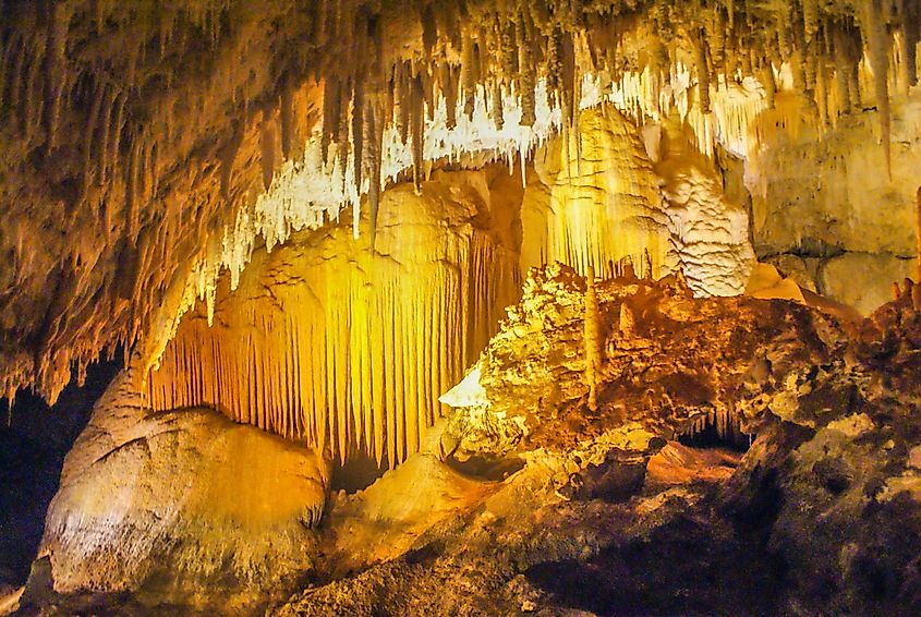
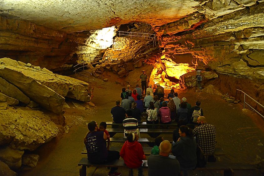
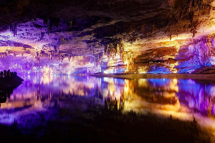
Mammoth Cave – 426.0 Mi
Mammoth Cave National Park Guided Tour, Kentucky, USA. This national park is also UNESCO World Heritage Site since 1981, via Wangkun Jia / Shutterstock.com
Located in theGreen RiverValley and rolling hills of south-central Kentucky,Mammoth Cave National Parkpreserves Mammoth Cave, the world’s longest-known cave system with over 426 miles of surveyed passageways. Two layers of rocks underline the national park’s hilly woodlands: the lower Mississippian-aged limestone strata capped by a layer of sandstone. The above sandstone layer contains leaks at places referred to assinkholes, from which surface water continuously moves underground, leading to the dissolution of the limestone and the formation of caverns. The Mammoth Cave features large horizontal passages with massive chambers, vertical shafts, stalactites, stalagmites, gypsum flowers, gypsum needles, etc. Mammoth Cave is home to over 130 species ofsubterranean faunae, of which 14 species of troglobites and troglophiles are known to exclusively exist here.
In the early 19thand 20thcenturies, several Native American remains, including mummified bodies possibly of pre-Columbian origin, were recovered from Mammoth Cave and other adjacent caves in the region. Over the years, the entire region developed into a popular tourist destination. At present, access to the Mammoth Cave is strictly controlled, and visitors are mainly restricted to 10 miles of developed passageways. In addition to cave visits, canoeing, hiking, fishing, wildlife viewing, and camping are some well-known activities offered by the Mammoth Cave National Park.
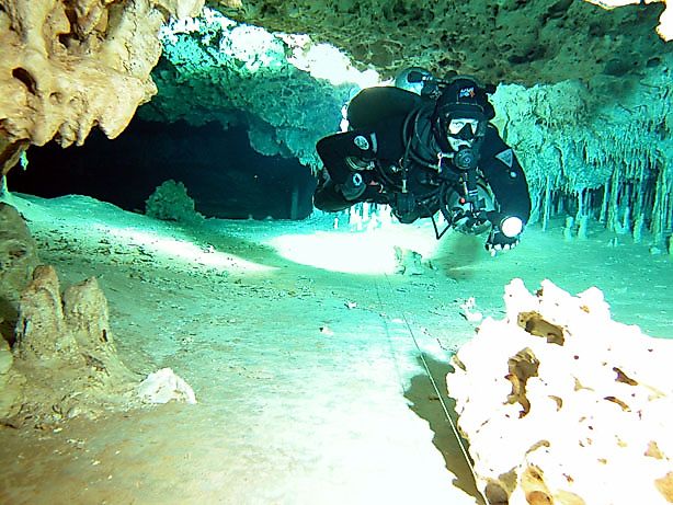
Sistema Ox Bel Ha or the Ox Bel Ha system, which means“Three Paths of Water”in the native Yucatec Maya language, is the world’s longest explored underwater cave and the 2nd-longest cave system having a total surveyed length of 270.8 miles of underwater passages. This complex system of limestone caverns and passageways is located immediately south of the Mayan town of Tulum in Mexico’s Quintana Roo state, close to the Sian Ka’an Biosphere Reserve. A team of experienced cave divers first discovered and explored the Sistema Ox Bel Ha cave system in 1996.
Ox Bel Ha encompasses many interconnected underwater cave systems, having over 150 cenotes, including Jailhouse cenote, cenote Naharon, Cenote Corazon del Paraiso o Chupich, etc. The principal feature of this cave system located close to theCaribbean Seais that a higher freshwater layer flows at the top of a near-static-salt-water layer. This results in the formation of a halocline, which occurs at different depths. A change in water level due to dailytidesis also clearly visible in several cenotes. As the freshwater moves closer to the ocean, the low flow that characterizes the cave on this side of the Yucatan Peninsula intensifies greatly. Therefore, advanced cave diving techniques are necessary for cave divers who wish to dive through the labyrinth of this cave system.
Three prehistoric human remains were discovered within Sistema Ox Bel Ha’s Naranjal subsystem. A skeleton of an 18 to 20-year-old woman and a 44 to 50-year-old woman were found around 1,207 ft and 1.2 mi away from the Jailhouse cenote entrance, respectively. The remains of a 40 to 50-year-old man were also discovered in Muknal Cave, which is a part of this Naranjal subsystem. A detailed analysis of these skeletons revealed that Sistema Ox Bel Ha was most likely used as a significant burial site. In addition, the Sistema Ox Bel Ha cave system is home to numerous subterranean life forms that have perfectly adapted to the cave's eternal darkness and unique conditions. The presence of these rare andendemic specieshas made Sistema Ox Bel Ha a crucialhotspotfor scientific research and conservation activities.
Shuanghedong Cave Network – 249.0 Mi
A scenic inside view of the Shuanghedong Caves with colorful lights
Located close to Suiyang County’s Wenquan town inChina’sGuizhou province is the Shuanghedong Cave,Asia’sand China’s longest as well as the world’s 3rd-longest cave with a total length of about 249.0 mi. Forming a part of the Suiyang Shuanghedong National Geopark, this cave features about 105 entrances, several waterfalls, and underground rivers that serve as crucial habitats for cave shrimp, blind fish, tadpoles, salamanders, leeches, spiders, and bats. The Shuanghedong Cave network was first discovered in 1987, and since then, about 20 expeditions have been conducted by exploration teams fromFranceandJapan. Recent laser mapping has also revealed that the cave is more extensive than initially expected. This cave network is tourist-friendly, and entry is allowed after a safety briefing at the Suiyang Shuanghedong National Geopark.
Sistema Sac Actun, or the Sac Actun system, which means“White Cave System”in the native Yucatec Maya language, is the world’s 4th-longest cave system with a total length of 239.9 mi. The discovery of Sistema Sac Actun’s connection with the adjacent Sistema Dos Ojos underwater cave complex in 2018 made it the world’s 2nd-longest underwater cave system. This extensive underwater cave system is located to the northeast of the Mexican state of Quintana Roo along the Yucatan Peninsula’s Caribbean coast on a sedimentary platform of Mesozoic and Cenozoic rocks. The Sac Actun cave system’s coastal sections are characterized by low horizontal tunnels forming mazes parallel to the coast and rudimentary conduits broken by fracture-controlled rooms. Access to the Sac Actun cave system is provided by multiple cenotes, such as Cenote Sac Actum, Cenote Dos Ojos, Cenote the Pit, etc., that dot the area. Over the years, teams of scientists and explorers have studied several miles of this cave system and discovered various archaeological and paleontological remains. For those who wish to explore Sac Actun, hire a local expert scuba guide having detailed knowledge about the different routes of this cave system.
Jewel Cave – 217.3 Mi
Jewel Cave in the USA
TheJewel Cave National Monument, placed approximately 13 miles west of Custer in the Black Hills of southwestern South Dakota, preserves Jewel Cave, the world’s 5th-longest cave with 217.32 miles of mapped passageways. Geological studies have revealed that a significant portion of the cave was formed within the Mississippian Pahasapa Limestone, deposited about 350 million years ago. The Jewel Cave features a succession of chambers joined by narrow passages. The cave is noted for its magnificent speleothems, including sparkling jewel-like calcite crystals or spar, stalactites, flowstone, frostwork, helictites, hydromagnesite balloon, etc. In addition, the Jewel Cave is also home to about 9 species of bats, among which 5 species are permanent residents. The ponderosa pine forest above the cave surface is inhabited by different fauna like elk, coyotes, white-tailed deer, and numerous avian species.
In 1900, two local prospectors, Frank and Albert Michaud, first discovered and explored the Jewel Cave. The Michaud brothers tried to capitalize on their discovery and opened the cave as a tourist attraction. However, even though their attempt was unsuccessful,President Theodore Rooseveltdesignated the Jewel Cave a National Monument on February 7, 1908. Systematic exploration of the passageways began only in the late 1950s. The National Park Service currently offers three tours to the Jewel Cave all year round: the hour-long scenic tour, the lantern-guided historic tour, and a four-hour-long wild caving tour.
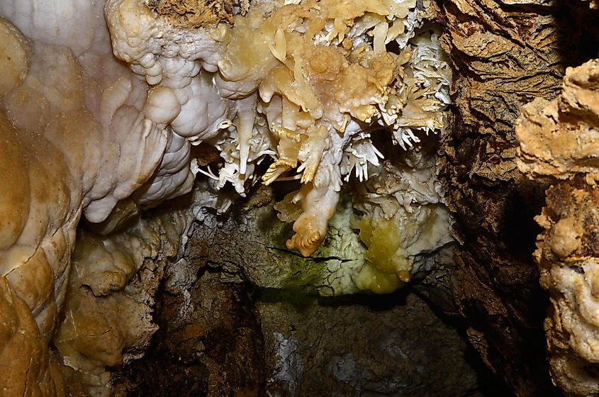
Optymistychna Cave – 164.4 Mi
Heliktit. cave Optymistychna, Ukraine.
Also referred to asPeschtschera Optimistitscheskayain the native Ukrainian language, Optymistychna Cave, with a total of 164.4 miles of mapped passageways, isEurasia’slongest, and the world’s 6th-longest cave. Located close to Korolivka village in Chortkiv Raion within westernUkraine’sTernopil Oblast, Optymistychna is also the world’s longest gypsum cave. The entire cave network lies underneath an area of about 2 sq. km in less than 98ft thick gypsum layer belonging to the Neogene period. Optymistychna is sometimes called a‘maze cave,’where the small cave passages form a dense network on several levels that are often clogged with mud. The cave’s gypsum bed is capped by a limestone layer that leaks into the cave through erosion, forming the calcite speleothems.
On May 8, 1966, a group of Lviv speleologists led by Myron Savchyn of“Cyclope,”the Lviv speleological club, first discovered the Optymistychna cave complex. Since then, there have been several expeditions to the cave. However, over the years, exploration activities have slowed down, and extremely few surveys are currently carried out. Optymistychna Cave was recognized as a“Natural Wonder of Ukraine”in 2008.
Wind Cave – 161.7 Mi
Inside the cave at Wind Cave National Park
The first cave to be designated as a national park, theWind Cave National Park, located about 10 miles north of Hot Springs in the western portion of South Dakota, containsWind Cave, theUnited States’3rd-longest and the world’s 7th-longest cave with 161.7 miles of explored passageways. Wind Cave is noted for its two unusual features: the reversible wind that continually flows in and out of the cave, equalizing the atmospheric pressure of the cave and the outside air; and an outstanding display of boxwork and frostwork calcite formations. Wind Cave is also considered the world’s densest cave system, with the greatest passage volume per cubic mile.
The Wind Cave National Park also includes the country’s largest remaining natural mixed-grass prairie that serves as an essential habitat for various native wildlife species such as bison, pronghorn, coyotes, elk, prairie dogs, raccoons, black-footed ferret, whooping crane, and many more. It is believed that the indigenous Native American tribes who lived in the area knew about an opening and regarded it as sacred for centuries. However, the first recorded discovery of the Wind Cave was by Jesse and Tom Bingham, who were attracted to the cave’s only natural opening by a loud whistling noise. From February 1892 onwards, the cave was opened for tourists. At present, various scheduled ranger-led tours to the Wind Cave are offered all year round.
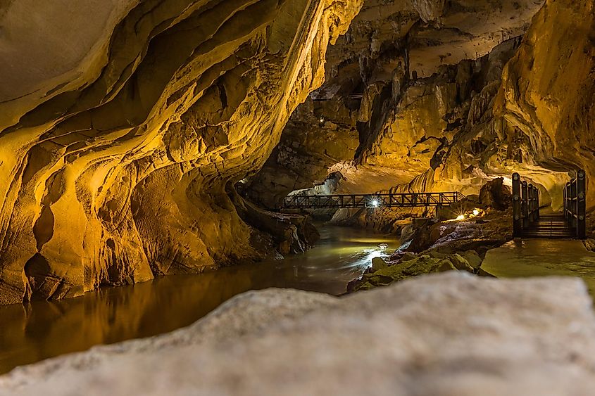
Clearwater Cave System – 159.0 Mi
The inside of Clearwater Cave System
Also known asGua Air Jernihin the native Malay language, the Clearwater Cave System, located inMalaysia’sGunung Mulu National Park, is the world’s 8th-longest cave,Southeast Asia’smost extended cave system, as well as one of the world’s largest interconnected cave systems by volume. The Clearwater Cave System is situated mainly beneath the western margins of the limestone mountain Gunung Api between the Cave of the Winds and Melinau Gorge. The first exploration of the Clearwater Cave System took place during the Royal Geographical Society Mulu Sarawak Expedition of 1977/78 when about 15 miles of cave passages were surveyed. Over the years, the Mulu Caves Project has conducted several expeditions that have increased the explored length of the cave.
It is interesting to note that the Clearwater Cave has an underground river, a portion of which is navigable by boat. One can reach the Clearwater Cave by trekking along a 2.48-mile-long nature trail or traveling by a long boat along the Melinau River. About 200 steps lead up through the forest to the cave’s mouth. A crystal-clear pool at the base of the steps offers visitors opportunities to take a refreshing dip.
Lechuguilla Cave – 150.4 Mi
Stalagmites, stalactites, and draperies by a pool in Lechuguilla Cave
The remote desert terrain of the Guadalupe Mountains in southeasternNew Mexico’sCarlsbad Caverns National Parkis home to the 150.4-mile-long Lechuguilla Cave, the world’s 9th-longest explored cave and the continental United States’s 2nd-deepest cave, reaching a depth of about 1,604 ft below the surface. Famed for its uncommon geology, stunning formations, and unspoiled condition, the cave has been named after the canyon through which it can be entered that, in turn, is named after the native plant species –Agave lechuguilla. Lechuguilla Cave contains a wide variety of rare carbonate and sulfate speleothems, such as hydromagnesite balloons, 20 ft gypsum chandeliers, 15 ft soda straws, lemon-yellow sulfur deposits, cave pearls, etc.
This deep hypogenic cave was formed by the oxidation of hydrogen sulfide from hydrocarbons in the adjacent Delaware Basin. The hydrogen sulfide was absorbed into oxygenated water on bedrock surfaces and oxidized to sulfur and sulfuric acid. The acidifiedgroundwaterthen infiltrated upward into the Capitan Formation’s carbonate rock, forming the Lechuguilla Cave. The reduction in aquifer level after the cave formation made it hydrologically isolated from phreatic groundwater. Moreover, the impermeable rock of the Yates Formation that overlies the Capitan Formation also makes the cave hydrologically isolated from above. Studies have reported the presence of rare chemolithoautotrophic bacteria in the cave. These bacteria are believed to feed on minerals (sulfur, iron, etc.), helping to enlarge the cave and determine the shape of the uncommon speleothems.
Until 1986, the Lechuguilla cave was considered an insignificant historic site at the Carlsbad Caverns National Park’s backcountry. The entrance passages were mined for small quantities of bat guano, while the cave’s 90 ft entrance pit namedMisery Holeled to 400 ft of dry, dead-end passages. In 1984, a group of cavers from Colorado Grotto led by Dave Allured started digging, and extensive walking passages were successfully discovered on May 26, 1986. Since then, explorers have mapped over several miles of passages. However, currently, as a crucial conservation measure, access to the Lechuguilla Cave is restricted to only NPS-approved scientific researchers and exploration teams.
Fisher Ridge Cave System – 131.8 Mi
Fisher Ridge Cave, Hart County, Kentucky, via Alan Cressler on Flickr
The world’s 10th-longest and United States’s 5th-longest cave, the Fisher Ridge Cave System is a 131.8-mile-long cave system located in Kentucky’s Hart County close to the Mammoth Cave National Park. It is believed that the Archaic Native Americans were the earliest visitors to the Fisher Ridge Cave System. In January 1981, the cave was rediscovered by a group ofMichigancavers belonging to the Detroit Urban Grotto of the National Speleological Society.
The Fisher Ridge Cave System comprises two massive segments linked by a 1000-foot-long crawl in between. The cave’s Northtown Ridge portion is about 80 miles long and includes numerous sizeable dry tunnels similar to the nearby spectacular and storied Mammoth Cave system. The 50-mile-long Fisher Ridge section contains many active streams and two principal mid-level trunk sections. An uninterrupted set of deserted trunk passages spans about 5.5 miles, stretching from one end of the cave to another.
However, despite a separation of only 600ft between the closest cave passages, it is yet to be ascertained whether a connection exists between the Fisher Ridge Cave System and the Mammoth Cave system. The closest connection between the two cave systems is situated high in the ridges between the discrete passages, which is most likely not favorable for any connection. Moreover, a drainage divide exists between a significant part of these two cave systems. Therefore, even if a link exists, it is thought to be located quite deep in the active base-level streams. The Fisher Ridge and Mammoth Cave explorers have been conducting continuous explorations in search of a connection or favorable passageways between the two cave systems.
Being one of the most awe-inspiring formations on the Blue Planet, caves have evoked an immense interest in mankind through centuries. These delicate natural resources house an array of archeological as well as paleontological records that provide a glimpse into the Earth’s evolutionary past. Therefore, exploring such a subterranean cavern opens a completely new world to researchers and enthusiastic travelers. So, whether you are a pro spelunker or an avid adventurer, you must not miss a chance to visit any of the world’s longest caves and gather memories of a lifetime.
When it comes to underwater archaeology, Rama Setu (also known as Rama’s Bridge or Adam’s Bridge,) is definitely one of the most perplexing. The “bridge” spans close to 48km and consists of a chain of limestone rocks between the southern coast of India and Sri Lanka. The bridge is currently completely submerged, but is said to have been passable by foot up until the late 15th century.
Is Ram Setu Real?
If the question is simply to whether or not the bridge is real, then yes, the bridge is 100% there. Although the Rama’s Bridge / Adam’s Bridge is currently completely underwater, it can still be seen through satellite imagery.
The Myths around Ram Setu
Probably the most interesting thing about Ram Setu is that it corroborates with the ancient Ramayana epic, written about 2,500 years ago. Based on astronomical information, the events that take place in the Ramayana are said to have happened roughly 7,000 years ago, although according to other calculations, it could be significantly more than that.
According to the story, the evil king Ravana kidnaps princess Sita, the wife of Lord Ram. After searching for many days, he is convinced that she is trapped on “Lanka,” which is separated from India by water. Ram then instructs his army of ape people to build a bridge across the water, thus saving the princess Sita.
Is Adam’s Bridge man made or a natural formation?
As with many underwater archaeological discoveries such as the Bimini road or the Yonaguni monument, the question was whether this bridge was really man made or was it just a natural formation.
A study of the area showed the rocks of the bridge to be roughly 7,000 years old. The interesting thing however, is that the rocks actually seemed to predate the surrounding sand, indicating that the bridge came first, and the sand filled it up underneath via normal waves and currents over the years. Another publication in 2007 stated that the bridge “may be manmade.”
While this is not conclusive evidence, there have been many other studies of the site. A team of divers that analysed the bridge stated that the bridge was not made of the usual marine material, as should be the case if it was a natural formation. Instead, it is formed of stones that can be found on either side of the bridge, where there is also evidence of ancient quarrying.
So how about the ape people?
Okay, so this is probably the weirdest part and this is pretty just my made up thoughts that come to my head late at night. Homo Sapiens are roughly 200,000 years old. In the process of our evolution, we seem to have made a very fast and sudden jump in intelligence, rather than gradually earning our place at the top of the food chain like creatures such as sharks.
That being said, is it possible that the army of “ape people” consisted of previous versions of the “homo” species which were much more ape-like than our current homo sapiens?
In conclusion
Personally, I think that regardless of whether Ram Setu is manmade or natural – and regardless of whether it is 1,000 years old, 7,000 years old, or a million years old – the interesting thing its sheer existence which seems to bind together reality as we know it and the world of myths and legends as stated in the Ramayana.
Whether Ram built the bridge, or whether he found it, whether he really had an army of ape people or whether the story was embellished over millennia, it still remains a fascinating piece of a history that we know almost nothing about.
Megalithic structures can be found all over the world, in almost every continent. While many megalithic and ancient ruins sites hold their share of mystery, some of the strangest megalithic monuments are the ones found in the most remote areas of the world – the middle of the Pacific Ocean.
Of all stages of ancient human migration, tackling something as colossal as the Pacific Ocean is easily among the most challenging. Why any of these people left their native homelands to explore the vast expanses of the open ocean remains a mystery. While there is some archaeological data on the settling of the major Pacific islands, much of it is still open to debate.
Yes, this picture is from Disney's Moana, depicting the Polynesian's journey across the Pacific.
Although we may not know all the details of how these islands were settled, we can still admire the legacy that these lost civilizations have left behind. Located thousands of miles from the nearest inhabited islands – here are a few of the most intriguing megalithic sites of the Pacific Ocean.
1. Nan Madol
Photo by CT Snow, Wikimedia commons
This strange city is found in Micronesia and is made up of a series of over 100 artificial islands connected by canals. The city is actually built in a lagoon on top of a coral reef, surrounded by water on 3 sides. The architecture of the site is considered a marvel of ancient engineering, consisting of large pillars of basalt rock stacked in a criss-cross fashion, without the use of any mortar or cement. These stones are similar to the ones seen at Gunung Padang. While some of the stones are light enough to be carried by one person, others weigh well over 50 metric tons.
Columnar basalt stones at Nan Madol (left) and Gunung Padang (right). Photos by Svetlana (Nan Madol) and Flame Rozario (Gunung Padang)
According to legend, the city was constructed by two sorcerers, with the help of levitating stones and a flying dragon. Considering that stones of this type are only found over 40 km away, it remains a mystery how the site was built.
Nan Madol from above- Drone image of Nan Dowas, collected with a DJI drone.
Nad Madol has no fresh water or food, both of which need to be received by boat from other islands. The earliest human activity dates to around 200 BC, although the main site of Nan Madol as we know it was constructed in roughly 1,500 AD.
2. Lelu Island
Lelu Island Ruins, Wikimedia Commons, Maloff1
Located 500km east of Nan Madol, Leluh island is yet another ancient ruin to be found in the federated states of Micronesia. Historical accounts by European explorers describe the city as an extensive network of canals and compounds constructed of huge boulders and basalt pillars. As with Nan Madol, the stones were quarried from the opposite side of the island. Whether they were transported by land or sea, or how they were erected remains unknown. Coral was also used extensively in the construction of the city. The city comprises of housing, temples, tombs, and other sacred spaces.
3. Stone Money of Yap Island
Photo: top5.com
To the west of Nan Madal, across a distance of 2,200 kilometers of ocean lies the island of Yap. On this island, we can find over 6,000 stone disks ranging in size and weight. The disks were important symbols of wealth, status and power. The stones were used as money, and their value increased based on craftsmanship or history. The smallest measures just 3.5cm across, while the largest stones stand 8 feet (3.6 meters) high, and weigh over 4 metric tons. The rocks were carved over 400 km from the island of Yap, and were at the time, the largest objects to be moved across the Pacific Ocean.
4. Pulemelei Mound, Samoa
Sometimes referred to as the “Samoan Pyramid,” the Pulemelei mound is the largest ancient structure in the Samoan islands. The pyramid is constructed of Basalt pillars, and stands 12 meters high. The structure consists of three levels, with slightly sloping walls.
The base of the pyramid measure 60 x 65 meters, and is shaped with eight points or cogs, giving it the appearance of a star when viewed from above.
Photo: BBC Travel
During a survey in 1978, archaeologists recorded more than 3,000 other features in the area, including stone platforms, fences, pathways, and ovens. The pyramid dates to roughly 1,100 AD.
5. Badrulchau, Palau
Photo: Sandwich, Wikimedia commons.
This is the most ancient Megalithic site in Palau, dating to around 150 AD. The site consists of over 50 Basalt megaliths, some weighing over 5 metric tons. The stones include 6 massive heads, as well as the remains of what is believed to have been a large bai, or meeting house. Other notable structures include a large stone sarcophagus located on top of a small hill. Also on this island, we can find the stone quarry which was used to construct the Yap money, which was then transported 400 km across the Pacific Ocean by canoe.
6. House of Taga
House of Taga in 1902.
The House of Taga is found on Tinian Island, part of the Northern Marianas Islands. This unique megalithic construction consists of a collection of stone pillars of roughly 4.5 meters in height. Each of the pillars is topped with a semi-spherical stone. Although there are roughly 15 of these standing stones, all but one has fallen. It is believed that these pillars were used as support for houses, to keep the inhabitants safe from flooding and wildlife.
7. Easter Island
We can’t quite go through megalithic sites of the Pacific Ocean without mentioning the famed Easter Island heads, (which also have bodies, as well all now know.) This volcanic island is an unlikely settlement, isolated over 3,700 kilometers from the mainland South America, and 1,700 kilometers from the nearest island. Scattered across the island are over 900 Moai, which are the giant heads that Easter Island is famous for. The island is said to have been settled by Polynesians around 400 AD, until the civilization met its eventual demise around 1860.
 300w,
300w, 


 300w,
300w, 


 https://commons.wikimedia.org/w/index.php?curid=1266817 3" />