On various walls across ancient Peru & Bolivia these animals depictions are not engraved or chiseled down into the stone, but instead exist as relief that sits above the flattened outer surface of the stones
The Famous 12-angled Stone In Ancient Inca Architecture, Machu Picchu, Peru
12 - Angled Stones are common, they are found here in Machu Picchu and at least 2 more in Cuzco. There are possibly some more found in several sites in Peru, Bolivia, plus more.
Andean Archaeology Revealed On An Unprecedented Scale
Astounding GeoPACHA software is advancing Andean archaeology. The new and innovative web application is allowing researchers to map archaeological features in the Andes mountains of South America with heightened precision and on a larger scale than ever before.
The Geospatial Platform for Andean Culture, History and Archaeology, or GeoPACHA, collects and coordinates high-resolution satellite imagery covering broad swaths of mountainous territory in central, southern and coastal Peru. The GeoPACHA site can be accessed from anywhere by researchers who have the necessary training to spot archaeologically significant ruins and formations.
Within Andean archaeology there may be thousands of previously undiscovered features just waiting to be found. While the discovery of a single new archaeological site can be exciting, it is the opportunity to find many such sites in identifiable distribution patterns that is creating so much buzz around the new GeoPACHA application.
“One of the most substantial challenges in archaeology is aligning the scales of our datasets with those of the social worlds that we seek to study,” explained the developers of the GeoPACHA software, Dr. Steven Wernke from Vanderbilt University and Dr. Parker VanValkenburgh from Brown University in the United States.
“Archaeologists are often asked to solve large-scale problems -- for example, to estimate the populations of ancient empires or to evaluate the effects of past climate change on settlement patterns across a continent –– but it's very hard, if not impossible, to use conventional archaeological methods to collect the kinds of systematic data needed to answer these questions.”
So far GeoPACHA has proven to be the ideal solution to this ongoing conundrum. Dr. Wernke and Dr. Van Valkenburgh have been joined by other researchers who study past Andean civilizations in their examinations of the initial GeoPACHA data sets, and already much has been learned about pre-Hispanic settlement and building patterns in Peru’s most mountainous terrain.
The Future of Satellite-Based Andean Archaeology Has Arrived
In a special collection of articles appearing in the journal Antiquity, researchers who’ve been analyzing GeoPACHA imagery report the results of their newly completed surveys of the Peruvian Andes. What has already been learned is rapidly transforming the practice of Andean archaeology and anthropology, as scientists are finally able to look at its rocky, hidden landscapes in detail and across hundreds of miles. From the vantage point provided by satellites they are tracing connections between freshly discovered sites that wouldn’t have been so obvious in the past.
“Imagery-based survey is capable of producing archaeological datasets that complement those collected through field-based survey methods, widening the scope of analysis beyond regions,” the authors of the new studies explained. “Using GeoPACHA, teams pursue problem-specific research questions through a common data schema and interface that allows for inter-project comparisons, analyses and syntheses.”
One of the most significant innovations associated with this new platform is its incorporation of artificial intelligence tools to assist in analysis. “Conducting manual surveys of satellite imagery is labor- and time-intensive, and low target prevalence substantially increases the likelihood of miss-errors (false negatives),” a team of experts led by Vanderbilt University archaeologist James Zimmer-Dauphinee wrote in one of the Antiquity articles.
They noted that their initial results using AI “suggest that future surveys may benefit from a hybrid approach—combining manual and automated methods—to conduct an AI-assisted survey and improve data completeness and robustness.”
Aerial photographs of archaeological features in the Andes. (Figure by authors; image copyright held by Maxar, reproduced under the NextView End User Licence Agreement. James Zimmer-Dauphinee / Antiquity Publications Ltd)
The First GeoPACHA Survey Results Are In, and the Implications Are Profound
The GeoPACHA system has already proven extraordinarily useful for examining and cross-referencing diverse and spatially separated surface features within Andean archaeology. In two of the newly published Antiquity studies, teams of archaeological researchers led by Dr. Giles Spence Morrow from Vanderbilt University in the first instance and Dr. Elizabeth Arkush from the University of Pittsburgh in the second describe the distribution of hilltop forts in the northern coastal and south-central highlands areas of Peru respectively.
These solid defensive structures were built by Andes people living in Peru during the Middle Horizon Period (500-1000 AD) and the Late Intermediate Period (1000-1450 AD), or in the last few centuries preceding the Spanish Conquest (the Spanish invasions of Peru began in 1526 AD).
Two hilltop forts or pukaras identified by Arkush in the survey. (Ryan Smith and ChristopheDelaere / ALTI-plano / Antiquity Publications Ltd).
In the second of these two related studies, the researchers analyzed hilltop fortresses distributed over a 58,000 square mile (151,103 square kilometer) area. This demonstrates the immense range of both satellite surveying technology and the new GeoPACHA coordinating system that is harvesting and processing its imagery.
In another intriguing GeoPACHA study freshly published inAntiquity, researchers led by anthropologist Dr. Giancarlo Marcone from Peru’s University of Engineering and Technology in Lima reveal a wealth of new details about the settlement patterns of ancient peoples who lived in scattered Andes oases known as ‘lomas’.
Until now very little has been known about how many people actually lived in these lush, green areas in pre-Spanish times. But GeoPACHA imagery has shown signs of human activity and settlement in quite a few of these patches of vegetation along the Andes coastline near Lima, revealing how the indigenous people survived in what was mostly an arid and desolate region.
“Lomas settlements are under-represented in archaeological datasets due to their tendency to be located in remote inter-valley areas,” Dr. Marcone and his associates explained. By employing satellite imaging to map the locations of human-built structures, they were able to identify “two categories of archaeological features, large corrals and clustered structures, and document a concentration of settlement features within lomas landscapes that suggests a pre-Hispanic preference for both short- and long-term occupation of these verdant oases.”
In yet another fascinating GeoPACHA study discussed in Antiquity, Drs. Van Valkenburgh and Wernke and their colleague Dr. Bethany Whitlock from Brown University disclosed extensive new information about the distribution of pre-Spanish pastoralist settlements in the Huancavelica region of Peru’s central interior.
“Recent archaeological research in the Andes suggests that Indigenous herders carefully managed their environments through the modification of local hydrology and vegetation,” the study authors wrote. “However, the limited geographical scale of previous research makes it challenging to assess the range and prevalence of pastoralist land management in the Andes.”
Through their examination of GeoPACHA imagery, the researchers discovered that indigenous corrals and pastoralist settlements “cluster around colonial and present-day settlements and that a statistically significant relationship exists between pastoral infrastructure and perennial vegetation.” This shows that the ancient inhabitants of the Peruvian Andes successfully identified the most fertile areas in the region for cattle grazing and for human settlements, and that later occupants simply followed their lead.
A Revolutionary Technology Unleashed
One of the early surprises of the GeoPACHA surveys is the discovery that ancient communities in the Peruvian Andes were not scattered evenly across the landscape. Approximately 95 percent of the area surveyed so far has revealed no signs of human occupation or activity.
“Because many of these areas are also not currently inhabited and are difficult to reach, they are also places where pedestrian surveys are less likely to be conducted,” Drs. VanValkenburgh and Wernke said. “The result is that our current models of settlement distribution are biased in favor of densely inhabited areas.”
It therefore seems that GeoPACHA is already upending some previous assumptions about the activities of ancient Andean peoples within Andes archaeology, which highlights the technology’s revolutionary implications.
The newly obtained GeoPACHA data is just the tip of the iceberg of what this type of archaeologically oriented application is capable of accomplishing. Satellites are now photographing every area of the arth, and as news of the success of GeoPACHA spreads archaeologists elsewhere will inevitably begin working on their own versions of this highly efficient and impressively effective technology.
Top image: Hillforts (pukaras) in the south-central highlands of Peru. Source: Elizabeth Arkush, Lauren Kohut, Romuald Housse, Ryan Smith, & Steven A. Wernke / Antiquity Publications Ltd
The destruction of Paquimé occurred long before the arrival of the Spanish. (INAH)
Share
The Paquimé archeological site is a testament that the north-south flow of goods and people has been crossing the “border” for millennia.
Though the site is hidden away in northwest Chihuahua state, the valley surrounding Paquimé once nurtured northern Mexico’s most important pre-Columbian culture.
Paquimé is referred to as “Casas Grandes” in English, but since that name also refers to the ancient culture and modern Pueblo Mágico next door, “Paquimé” distinguishes the site better. Either way, the translation to English is the same: “big houses.”
Northern and southern influences in the architecture
Those “big houses” are what strike you first when you enter Paquimé, distinguishing it from every other archeological site in Mexico. The living structures are large, interconnected rooms for the culture’s elite that arose and changed as the Casas Grandes culture developed from 700-1475.
They are the strongest architectural evidence for classifying Casas Grandes as a Mogollon culture, one of several that shaped parts of the present-day states of Chihuahua, Sonora, New Mexico and Arizona.
Exhibit at the Casa Chihuahua regional museum in the state capital meant to give some idea of what life was like inside one of the “big houses” of Paquimé (credit Leigh Thelmadatter)
These kinds of adobe constructions can be seen farther north, but not to this sophistication. The adobe “bricks” were made by pouring water and earth into molds set to dry on top of walls, allowing for up to four stories. The very dry climate and overhanging roofs made the firing of bricks unnecessary.
Upon closer inspection of the site, important similarities with Mesoamerica appear. The most indisputable evidence of such influence is the Mesoamerican ball court. Plazas, columned patios and environmentally-situated mounds/pyramids also demonstrate links. But perhaps the most surprising example is the Macaw House. Far from their southern habitats, macaws were raised and sacrificed here despite the harsh climate.
An evolving understanding of Casas Grandes history
This evidence initially led archeologists to see Paquimé as a Mesoamerican outpost, but Casas Grandes was an independent society with important cultural and economic connections, from northwestern Mesoamerica to Old Pueblo territory in New Mexico.
Its status as a Mogollon site is based on the agreement that the valley was settled by migrations of people from the north, mostly likely escaping drought. Casas Grandes pottery has striking similarities with ancient and modern pottery from what is now the southwest US.
For simplicity, the culture’s history can be divided into three periods. The Viejo (old) period (700-1060) covers the transition from hunter-gatherer to agricultural subsistence and the appearance of the first villages along rivers and streams, fed by waters from the Sierra Madre Occidental.
The Medio (middle) period (1060-1340) is marked by the rise of Paquimé imposing a centralized command over the valley’s villages and a population of over 10,000. The big houses and pottery reach their height at this time.
Evidence of instability appears as early as 1150, but a sacking in 1340 marks a period of slow decline called the Tardío (late) period, which likely ended in 1475. Trade activity, the development of fine pottery and the construction of “big houses” continues, but the elite’s hold on power is eroding.
Mata Ortiz pottery, while clearly inspired by ancient Paquimé, takes liberties with the geometric designs and vessel shapes. (credit Alejandro Linares García)
Paquimé suffers complete destruction in 1475, with everything in sight destroyed in fire. Why is strongly debated. Internal strife caused by drought is a good possibility, but Paquimé’s great trade wealth also made it a target.
Registered tour guide Azucena Durán offers another explanation that has limited prominence in academic sources. The ball court and evidence of human sacrifice, she says, may indicate that Mesoamerica was pushing their hegemony to a point that the locals could no longer permit, choosing to destroy their city rather than submit – perhaps it’s an allegory of northern Mexico’s ambivalence to Mexico City.
The destruction of Paquimé occurred long before the arrival of the Spanish, who discovered its ruins. Some archeologists believe that survivors from its demise fled to the mountains and that their descendants fought the Spanish before they disappeared.
Trade links north and south – then and now
The lack of written records hinders our understanding of Paquimé, but artifacts leave no doubt that it was a rich city with far-flung connections.
The market of the main plaza reveals a wealth of local and “foreign” items, but three are of the greatest interest: turquoise, copper and seashells.
By far, the most common are shells from the Pacific, both worked and raw, which served as a currency and store of wealth. The turquoise and copper prove Paquimé’s north-south reach, sourced from “New Mexico” and western Mesoamerican respectively. Paquimé yields only small quantities of both, likely because Paquimé was a conduit for the jewelry trade – an assertion supported by the fact that turquoise was very rare and extremely valued in Mesoamerica, as was copper in the far north.
Paquimé and modern northern Mexico identity
Example of a Paquimé-inspired tattoo from the Omuro Tatuajes.(Facebook page – artist El Samuko)
Though Paquimé fell long ago, north-south trade remains as important as ever, as evidenced by the trucks and freight trains that traverse central Chihuahua today.
In recent decades, Paquimé and the Casas Grandes culture have experienced a resurgence in importance, especially for regional identity. Northern Mexico has always been a shifting cultural and demographic landscape. Influence still flows in from the north and the south, but today, those influences stem from modern Mexico City and the mostly Anglo culture of the United States.
But pride in being a chihuahuense has prompted modern inhabitants to appropriate the iconography of Casas Grandes.
The first manifestation of this was Mata Ortiz’s pottery, a recreation and modernization of Paquimé work which first achieved commercial success north of the border and today receives more respect within Mexico. Even more recent is the rise of Casas Grandes-style tattoos among the youth of Chihuahua city.
Still, the Paquimé site has not garnered the same attention that Teotihuacan and other Mesoamerican sites do, despite being named a World Heritage Site in 1998. Only in 2022 did state and federal authorities finally build a site museum well worth a visit.
But there are some distinct advantages to this. The lack of walls and other protections means you can enter the site anytime, appreciate the structures as they relate to their surroundings and be blessedly free from vendors and other tourists.
Leigh Thelmadatter arrived in Mexico over 20 years ago and fell in love with the land and the culture in particular its handcrafts and art. She is the author of Mexican Cartonería: Paper, Paste and Fiesta (Schiffer 2019). Her culture column appears regularly on Mexico News Daily.
Digital transformation, one of the most overused terms of the last few years, acquires special interest when it refers to cultural institutions. Even more so when the institution in question is the National Archaeological Museum (NAM), Greece’s largest, which for decades had been lagging behind in terms of its digital profile.
The Culture Ministry aspires to change this reality with a comprehensive program “to modernize and highlight the NAM” using 1.5 million euros in EU funding, which was presented on December 19.
Changes include a new secondary website, ds.namuseum.gr, where one will be able to book any museum activity and plan a visit. The museum will offer 32 new thematic guided tours which will be available in rotation (nine available at a time). Visitors will also be able to do a virtual tour and select specific exhibits in a personal folder as memories of the visit.
‘Our museums serve as managers and curators of cultural heritage. Museum policies must change to serve social needs, and not to ultimately become museums themselves,’ says Culture Minister Lina Mendoni
“Our museums serve as managers and curators of cultural heritage. Museum policies must change to serve social needs, and not to ultimately become museums themselves,” said Culture Minister Lina Mendoni. “With this specific project, NAM harmonizes its operation with the requirements of the era and the new generation. Also, foreign visitors, who will enjoy this renewed experience, will serve as the best ambassadors of our culture around the world.” Meanwhile, two information stations inform about available themed tours, current and future activities, and allow visitors to send a digital postcard to a friend with one of the museum”s exhibits. In the center of the main hall there is a new circular kiosk, created with the sponsorship of Aegean Airlines, which offers audio tour devices, free of charge, to explain the museum’s permanent collections.
Next to the display case with gold masks of the Mycenaean tombs, there is now a series of three-digit codes which can be typed into the audio tour device to hear the relevant excerpt. “Stories about love and infidelity, war and peace, the first computers and tablets,” explains Anna-Vasiliki Karapanagiotou, general director of the museum.
These special podcasts, while still experiencing some technical problems which are expected to be overcome, are available in six languages and cover a total of 883 exhibits, while separate texts have been compiled for guided tours in sign language and for the visually impaired.
An additional service, which will be activated soon, is a mobile application for the museum’s most iconic exhibits, while nine digital information islands have been placed in as many rooms, enriching the thematic tours with videos, as they are automatically coordinated with the visitors’ devices.
Regarding the planned expansion of the museum, Mendoni said that the agreement for the required studies will be ratified in Parliament within the first two months of 2024. The date of the ratification will affect the timeline for the completion of the project and the sections of the museum that will be closed.
As for the halls that remain closed due to lack of staff, the minister said that the new board of directors is going to submit a request to the Supreme Council for Civil Personnel Selection (ASEP) in 2024 to fill the positions.


 The National Archaeological Museum of Athens is introducing a secondary website for booking activities and planning visits. [Intime News]
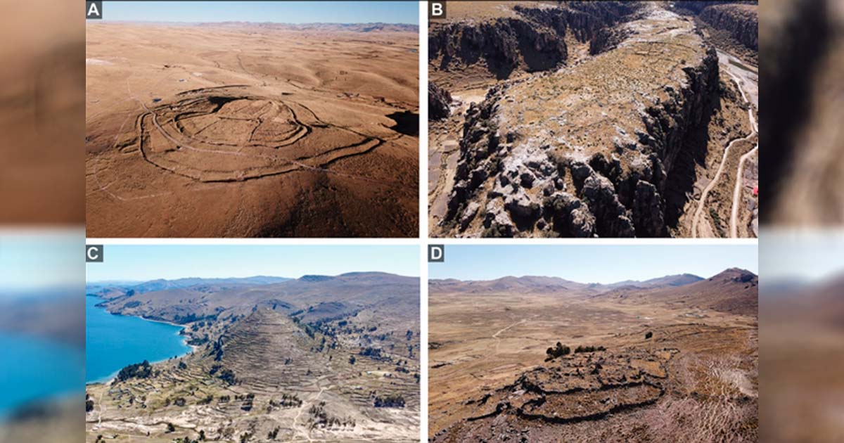


")