Calakmul, El Mirador, La Ciudad Blanca, plus more are mentioned in this video.
I'm headed back to the Jungle tomorrow!
Video
( Please scroll to these Mayan sites and more however I do recommend you watching the whole video )
Calakmul - 15:27
El Mirador - 16:58 and 1:15:51
Bonampak - 33:42
La Ciudad Blanca - 35:51
West Amazonian civilization - 52:00
Xpujil - 1:02:51
Chichen Itza - 1:10:21
Palenque - 1:10:51
The host mentioned large stelae, Mayan codices, Aztecs ordering 485,000 pieces of paper a year, Mayan population were 3 times larger than anywhere basically in the world, plus more.
Vast network of 2,500-year-old garden cities discovered in Amazonia
The Amazon rainforest was once home to ancient cities, confirms 'Science' magazine, which has published a description of the largest and oldest known Amazonian settlement in Ecuador.
Published on January 11, 2024, at 8:10 pm (Paris), updated on January 11, 2024, at 8:22 pm
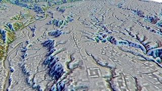
Kunguints site, Upano Valley, Ecuador. Complexes of rectangular platforms are arranged around low squares and distributed along wide, dug-out streets. IMAGE LIDAR A. DORISON ET S. ROSTAIN
At the end of 1541, Spaniard Francisco de Orellana, accompanied by a few dozen men, set out from the eastern foothills of the Ecuadorian Andes on an incredible river journey that would take him from west to east across the entire South American continent, ending in the Atlantic Ocean via the Amazon River. Dominican national Gaspar de Carvajal chronicled the perilous 10-month journey, during which he lost an eye, struck by the arrow of an Indigenous tribesperson in an ambush.
In the account entitled Descubrimiento del rio de las Amazonas ("Discovery of the Amazon River"), Carvajal depicted densely populated riverbanks and what resembles an urban cluster: "No village was more than a crossbow shot away from the other (...) and there was a village that stretched for five leagues without interruption from house to house, which was a wonderful thing to see." At the time, people took this description to be a fabrication. However, an international study published on Thursday, January 11, in Science reveals a network of garden cities along the Upano River in Ecuador, dating back to 500 BC. It's the oldest and largest urban network in Amazonia. As Carvajal and Orellana claimed, the pre-Hispanic Amazonian city is a reality.
Archaeologists used lasers to view an ancient civilization hidden in the Amazon rainforest.
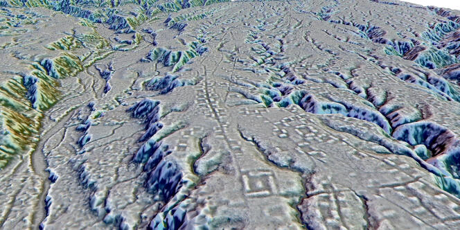
Archaeologists used lidar to get a better picture of the ancient urban center.(Image credit: Stéphen Rostain)
Lasers have revealed a complex network of pre-Hispanic structures and roadways hidden beneath the canopy of the Amazon. At 2,500 years old, it's the earliest (and largest) example of an agricultural civilization ever recorded in South America's dense rainforest.
Archaeologists have been studying the Upano Valley site, located along a stretch of the eastern Andes, for several decades. However, it wasn't until they began viewing the Ecuadorian landscape using airborne lidar (light detection and ranging) — in which thousands of infrared laser pulses are reflected repeatedly off the landscape to reveal structures hidden beneath the vegetation — that they realized how elaborate the civilization actually was, according to a study published Thursday (Jan. 11) in the journal Science.
"I have explored the site many times, but lidar gave me another view of the land," lead study author Stéphen Rostain, an archaeologist and director of research at the French National Center for Scientific Research (CNRS), told Live Science. "On foot you have trees in the way, and it's difficult to see what's actually hidden there."
Archaeological excavations showed that the site, which covers approximately 230 square miles (600 square kilometers), was occupied from roughly 500 B.C. to sometime between A.D. 300 and 600, according to the study.
Researchers employed lidar to assess half of the expansive site, which was constructed by members of the pre-Hispanic Kilamope and Upano cultures, two sedentary agrarian societies that once occupied the valley. After a "hiatus," some of the settlements were occupied by the Huapula culture, according to the study.
Earthen platforms were found throughout the site. (Image credit: Stéphen Rostain)
Lidar images showed that the site contained more than 6,000 rectangular earthen platforms, plaza structures and mounds that were interconnected via an extensive gridwork of straight roadways and footpaths.
"The streets not only crisscrossed throughout the site but also led outside of the site," Rostain said. "These roadways all functioned together and were used to connect the community."
The researchers also discovered groupings of nearly 15 "distinct" settlement sites that ranged in their size and number of structures, according to a statement.
Some of these settlements also had "huge mounds" that stretched up to 492 feet (150 meters) long and stood 26 feet (8 m) high, Rostain said, adding that "it's impressive" how elaborate the site is in both the variety of constructions and the enormity of some of the structures.
Based on its sheer size and complexity, the site "resemble[d] similar Maya urban systems in Central America," according to the statement.
"Such a discovery is another vivid example of the underestimation of Amazonia's twofold heritage: environmental but also cultural, and therefore Indigenous," the study authors wrote in their paper."…we believe that it is crucial to thoroughly revise our preconceptions of the Amazonian world and, in doing so, to reinterpret contexts and concepts in the necessary light of an inclusive and participatory science."
Jennifer Nalewicki is a Salt Lake City-based journalist whose work has been featured in The New York Times, Smithsonian Magazine, Scientific American, Popular Mechanics and more. She covers several science topics from planet Earth to paleontology and archaeology to health and culture. Prior to freelancing, Jennifer held an Editor role at Time Inc. Jennifer has a bachelor's degree in Journalism from The University of Texas at Austin.
The pipette is a rare rock art motif found across the North American Southwest but seldom depicted in other media. We address landscape and archaeological contexts, associated imagery, material correlates, and ethnography to provide an interpretative hypothesis that accounts for the motif’s widespread, cross-cultural use. We argue that pipettes represent a tiered cosmos and axis mundi, at times with portrayals of emergence and transcendence. The pipette’s compartmentalization signifies the conceptual metaphor ‘the cosmos is comprised of containers’, a concept embedded in Uto-Aztecan languages with Mesoamerican antecedents. The motif’s distribution across the North American Southwest demonstrates that it was a key religious symbol that accompanied the adoption of Mesoamerican-like religious beliefs and practices beginning in the eighth century or before. Prehistoric iconography – whether we understand it or not – references thought and ideas that were important enough to memorialize. Despite difficulties inherent to interpretation, archaeology would be remiss not to take advantage of the enduring iconological record. We demonstrate that careful, concentrated, and multidimensional approaches to understanding prehistoric symbolism can provide valuable and credible insight into cultures that otherwise could not speak for themselves.
480w,
650w,
970w,
1024w,
1200w" data-sizes="(min-width: 1000px) 970px, calc(100vw - 40px)" data-original-mos="https://cdn.mos.cms.futurecdn.net/E8TryDTGJbLo7f8cvKuuRh.jpg" data-pin-media="https://cdn.mos.cms.futurecdn.net/E8TryDTGJbLo7f8cvKuuRh.jpg" data-ll-status="native" />