Tags
Tab Item Content
Join Us!
Archives Meta
Archaeology by Prau...
 
Notifications
Clear all

Archaeology [Sticky] Archaeology by Prau123

1,649 Posts
12 Users
27 Reactions
4.3 M Views
Prau123 avatar
Posts: 3145
Topic starter
(@prau123)
Famed Member
Joined: 6 years ago


Mapping Modern Threats to Ancient Chacoan Sites


Mapping Modern Threats to Ancient Chacoan Sites

The Chaco civilization flourished for hundreds of years in what is now the southwestern United States, reaching its height between about 1000 and 1100 CE. In modern times, researchers have been piecing together a picture of Chaco culture based on artifacts excavated across hundreds of archaeological sites. They have found a range of structures such as multi-story “great houses,” many connected by a network of roads. They have even probed the ancient DNA of human remains to learn more about the Chaco people and how they structured their society.

But while some archaeologists have boots on the ground, other researchers are learning about the ancient civilization with data collected from space. That was the approach in spring 2017 for a research team sponsored by NASA’s DEVELOP program. Led by Kelsey Herndon of the University of Alabama in Huntsville, the team used NASA satellite observations and other data to map the potential locations of yet undiscovered Chacoan sites. They then applied a modeling technique to map the risk of disturbance to archaeological sites across the entire San Juan Basin.

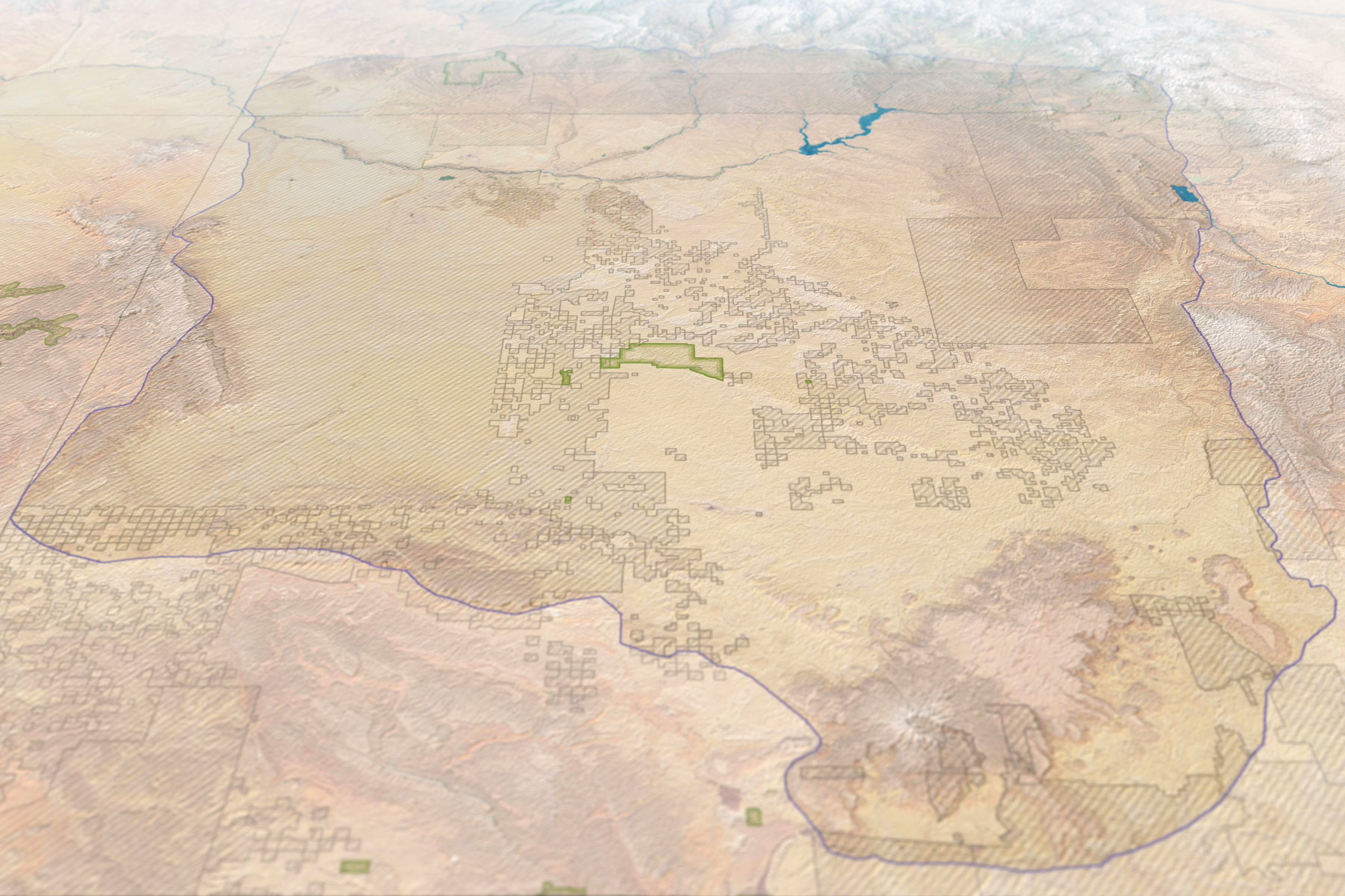
The basin, outlined in the top map, spans about 19,400 square kilometers (7,500 square miles) of the Four Corners region of the American Southwest. Many of the Chacoan sites, concentrated in New Mexico within the boundaries of the Chaco Culture National Historical Park, are protected by federal law. But sites outside the park boundaries are at risk of disturbance by modern infrastructure.

“Using NASA Earth observations allowed us to really understand the scale of the potential damage to these ancient sites from oil and gas mining and encroaching settlements,” Herndon said. “It would be extremely difficult and impractical to assess the susceptibility of all of these sites individually. High-resolution satellite imagery and models complement the excellent work being done by archaeologists on the ground and allow us to address this problem quickly over a large area.”

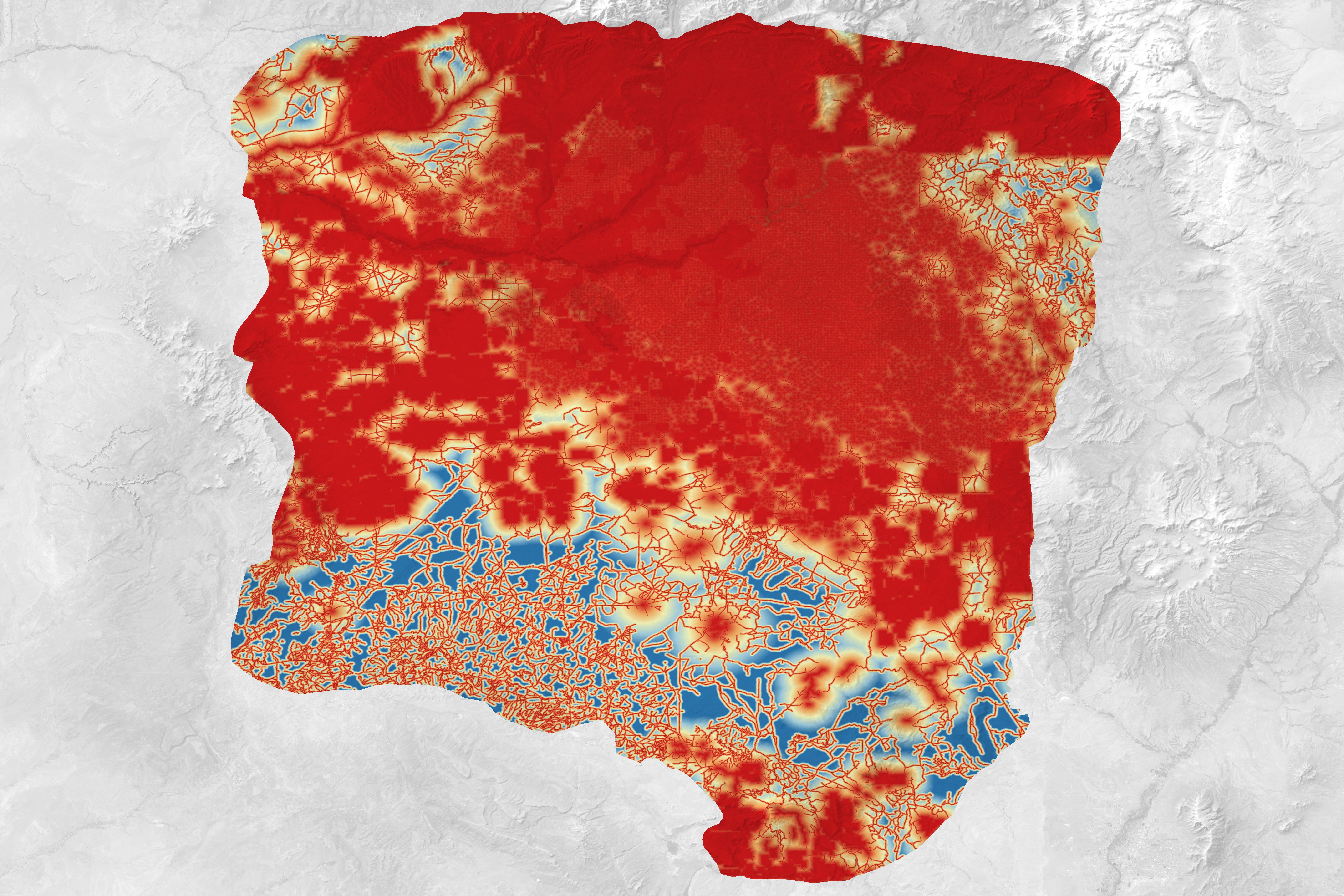
The second map shows the relative level of risk of disturbance from low (blue) to high (red) across the basin. Herndon and her team determined these risk levels by considering an area’s proximity to modern roads, water features, and existing or planned oil and gas drilling operations. They also considered the expected population growth for the area between 2015 and 2020.

By considering all of these factors, the team found that 44 of the 123 known Chaco sites included in the study are threatened by development. Of those, 19 are already protected by the National Park Service.

“These maps are available to help the National Park Service better understand which sites could be prioritized for inclusion in future protected areas.” Herndon said. “Understanding the susceptibility of these sites to expanding infrastructure is more important now than ever as population pressures in the region increase and oil and gas exploration is on the rise.”

NASA Earth Observatory images by Joshua Stevens, using Landsat data from the U.S. Geological Survey, topographic data from the Shuttle Radar Topography Mission (SRTM), and risk analysis courtesy of Kelsey Herndon and the NASA DEVELOP Program. Story by Kathryn Hansen.


Article


Mapping Modern Threats to Ancient Chacoan Sites (nasa.gov)


Reply
Prau123 avatar
Posts: 3145
Topic starter
(@prau123)
Famed Member
Joined: 6 years ago


Scientists Discovered A Pre-Historic Mega Structure On A Mountain You Never Knew Existed


Ollantaytambo, a vast complex situated in the Sacred Valley of the Incas northwest of Cusco, is renowned for its exceptionally precise megalithic polygonal masonry. Among its most notable structures is the Temple of the Sun, which features impressive stonework. This includes massive slabs of pink granite, intricately carved and precisely aligned. These stone blocks, weighing between 50 and 70 tons each, are so precisely fitted together that not even a sheet of paper can slide between them. Remarkably, these blocks were transported from a different mountain, across a plain and a river, before being brought up the mountain to Ollantaytambo. The precision, scale, and transportation of these stone blocks demonstrate a highly advanced level of technological and engineering sophistication, leading some to believe that such capabilities were beyond the reach of the Incas at that time.


Video


Reply
Prau123 avatar
Posts: 3145
Topic starter
(@prau123)
Famed Member
Joined: 6 years ago


Return to the Impossible: I Found New, Shocking Evidence


Video


Reply
Prau123 avatar
Posts: 3145
Topic starter
(@prau123)
Famed Member
Joined: 6 years ago


One day in July 1908, the Italian archaeologist Luigi Bernir was conducting an excavation in the remains of the palace of Phaistos. He was about to finish his day when a worker told him full of emotion that he had found something incredible. When the Italian saw what it was about, he was speechless ... it was a thousand-year-old record. The disc of Festos.


Video


Reply
Prau123 avatar
Posts: 3145
Topic starter
(@prau123)
Famed Member
Joined: 6 years ago


They just opened the National Museum of the Philippines Tabon Cave Complex and Lipuun Point. Located under a massive set of limestone cliffs with huge historical significance (I will explain in a future post), this place is not only beautiful, but full of unique learning opportunities! Did you know that the northern half of Palawan is a fragment of the Asian continent that rifted away during the formation of the South China Sea around 40 million years ago (mya). As this fragment drifted southward, it collided with Borneo and Cagayan Ridge sometime between 20-15 mya. The collision resulted in the emplacement of the ophiolites on the Palawan Continental Terrane (PCT)! Did you know there is evidence of local weaving from more than 30,000 years before present? Did you know the Tagbanua and Pala’wan people used Alphasyllabic scripts? Well, what I know, is I learned an incredible amount of history here at this museum. The staff were incredibly knowledgeable, the exhibits were informative, and the area was just stunning! So happy to have had the opportunity to visit this place in Palawan. One of my favorite experiences ever in the Province. Power On!


Video


Reply
Page 205 / 317