Vietnam has lost chunks of land to Laos, Cambodiaand Chings because of the French boundary treaties, and huge chunks of maritime boundaries in the Gulf of Tonkin and the Paracels.
I've heard Sabah was originally a part of the Philippines.
Is there anymore that was lost from the Philippines
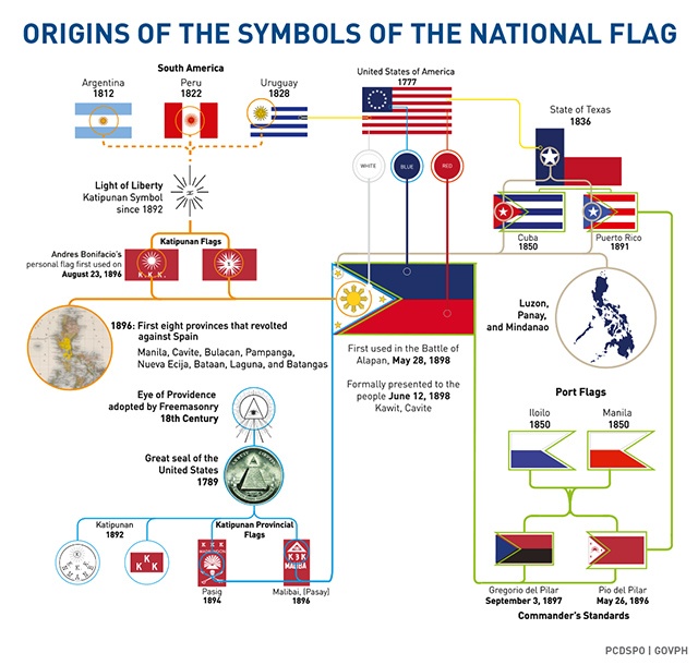
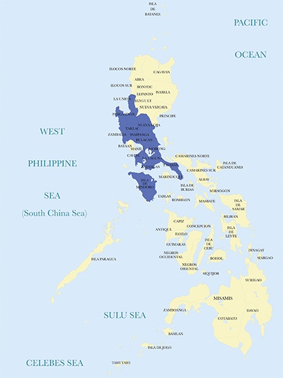
(SPOT.ph)We markIndependence Daywith displays of the flag, and generations of schoolchildren are reminded of its evolution, and the meaning of the sun and stars on it. The first eight provinces placed under Martial Law when the 1896 Revolution began, and the three main geographical groups of the nation, Luzon, the Visayas, and Mindanao.
If you look into things a bit more, you’ll discover that what we’ve been taught has evolved over time. The star that we identify as the Visayas as a whole for example, was originally identified as Panay; the red, white, and blue are a tribute to the American flag, and so on.
Share
The same applies to what we consider to be our country. We consider it a kind of organic whole that always was, and will always be. But it wasa creation of a specific point in time: the collapse of the Spanish Empire in Asia, the rush to pick up the pieces by newer colonial powers, and the edging aside of Filipinos trying to create their own country.
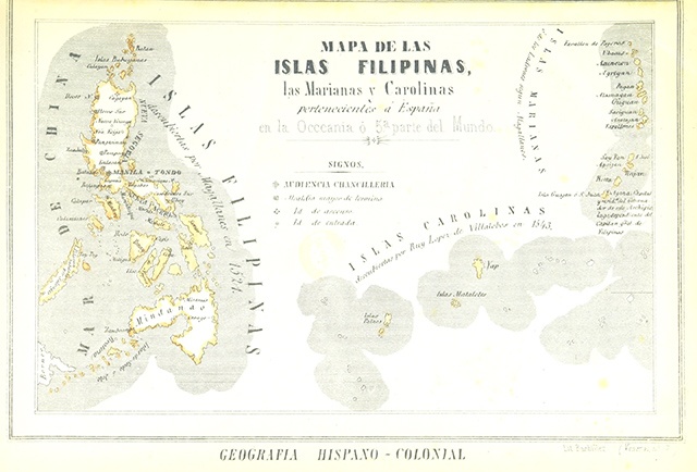
A Spanish historian once told me that while the Filipinos obsessed overSabah (North Borneo)and theSpratleys, we could just as easily obsess over a Philippines that stretched from the Spratleys on one side, all the way to Guam on the other. Naturally, I asked him why that was. He replied, “Because under Spain, the definition of the Philippines included not just what you consider your country today, butPalau(now the Republic of Palau), theMarianas(now known as the Commonwealth of the Northern Marianas and the separate island of Guam), theCarolines(which was also referred to as the New Philippines, now known as the Federated States of Micronesia).” Collectively, this sprawling set of islands was referred to by the Spaniards as theSpanish East Indies(in contrast to, say, theDutch East Indies, which was the pre-independence name for Indonesia), and were ruled fromManila.
Share
Philippine map from 1857. The Philippines as the Spanish viewed and administered it until 1898. Palaos is Palau; Carolinas is Micronesia; Guajan is Guam, with its capital, Agaña, labeled “Capital and residence of the governor of this archipelago, a dependency of the Captain-General of the Philippines.”
What is interesting—and requires study, to my mind—is how and whythe Filipino concept of what constitutes our country deviated from that of the Spaniards. For example, “Will the distinguished gentleman from Palau please register his vote,” would have been a normal statement to hear, in the sessions of the Malolos Republic. That’s becausePalau was considered part of the Philippines by our First Republic. But why not the Carolines, or the Marshalls, or even Guam (which was, in terms of Church administration, for example, considered part of the Archdiocese of Cebu)? These places weren’t included in the Philippines, even by our revolutionary generation.
Our Moro brethren nowadays challenge, as well, for example, the inclusion of Mindanao in our standard definition of the Philippines, while the Malolos Republic considered it part of the country. On the other hand, in the Visayas, the urge toward Federalism has always been strong –so where did it come from? The simple answer is:It’s complicated.
On our Independence Day, it would be good to see howour country evolved not from one, but in a sense, many revolutions.Each one contributing to the geographical and political entity we call home. These maps put online by the government in past years, serve as a helpful guide to understanding what happened and why some parts of our national story continue to be hotly debated until now.
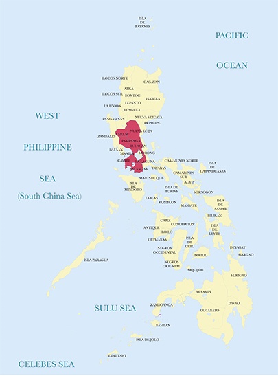
The French famously said that a revolution devours its own children, and our Independence Day, June 12, is a tell-tale sign of this. While historians continue to heatedly debate where and how the start of the Revolution against Spain began (Balintawak or Pugad Lawin? Take your pick), one thing is sure:We don’t mark our Independence Day on the date that revolution beganunlike most other countries that trace their origins to a revolution. But this airbrushing can’t totally erase Bonifacio, the Katipunan, or the moment in time the Spaniards finally realized they had more than your usual localized revolt on their hands. That moment wasAugust 30, 1896, whenGovernor-General Ramon Blancoproclaimed Martial Law in eight provinces: Manila, Laguna, Cavite, Batangas, Pampanga, Bulacan, Tarlac, and Nueva Ecija. (Yes,Manila was also a provincewith its own territory in that era.)
Interestingly,these provinces aren’t exactly the eight rays of the sunin our flag. The June 12, 1898 proclamation of independence says the rays represent “Manila, Cavite, Bulacan, Pampanga, Nueva Ecija, Bataan, Laguna and Batangas” as the provinces placed under Martial Law, substituting Bataan for Tarlac.
Share
Proclamation of Martial Law on August 30, 1896: when the Spaniards recognized they had a serious situation on their hands.
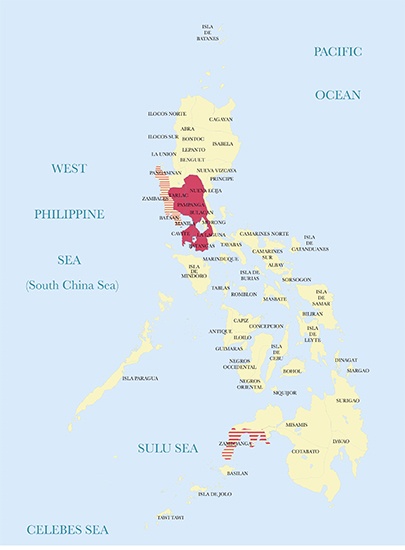
What we often overlook is how the Spaniards, too, two months later, on October 25, 1896, recognized that things were getting even more out of hand. On that date, the same Governor-General Blanco issued another proclamation, this time placing Bataan, Zambales, and Sibugay (in the then-province of Zamboanga) also under Martial Law. So Bataan belongs to the second set of provinces placed under Martial Law, two months after the Revolution began, and ended up edging out Tarlac in the flag.
Share
Extension of Martial Law in October 1896: The Zamboanga part is complicated, best explained in the original presentation: “Ken from the Universitat Pompeu Fabra website illustrates an area corresponding roughly to Zamboanga. However, this map seems to indicate the present political boundaries of Zamboanga, Sibugay. Our extrapolation to resolve this is to represent the Martial Law proclamation as covering the then province of Zamboanga.”
By 1897 if you asked the Spaniards which provinces theindioswere uppity enough to have engaged in revolt, they would have pointed to a map like the one below. The dark red portion shows thefirst provinces to have risen in revolt; the parts in pink showshow widely the Revolution had spreadbefore it began to be rolled back after reinforcements were brought in, while the Revolution itself had led to a purge of its original leadership (Bonifacio) in Tejeros in the early part of 1897, when the Katipunan government was abolished and replaced by a Revolutionary government. By December 18, 1897, Aguinaldo had abolished the revolutionary government and put up theBiak-na-Bato Republic, which signed a peace treaty with Spain. On December 27, 1897, Aguinaldo went into exile, setting up the Hong Kong Junta.
Share
The Spanish view, at least, of the maximum extent of the First Phase of the Revolution, which came to an end in late 1897.
While Aguinaldo and friends continued to plot in exile, and Spain thought it had won, there were others who decided to take up arms once again. In February 1898, a revolt erupted in Cebu under the leadership ofFrancisco Llamaswho’d been a municipal treasurer in the town of San Nicolas. The revolutionary committee that was established proved durable: It would later recognize theAuthority of Aguinaldowhen he returned to resume the Revolution (its Second Phase).
Share
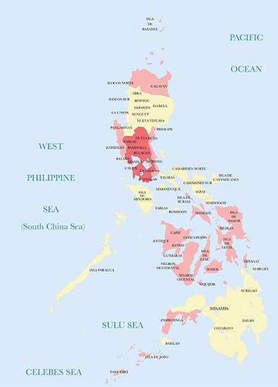
Cebu revolts, early February 1898
A month after Cebu rose up in revolt, Panay started preparing to do the same. With the daring name of “The Conspirators’ Committee” and its headquarters in Molo, meetings began in March 1898 and led to the formation of theRevolutionary Central Committee of the Visayaswhen the revolt began in August 1898, evolving, in turn, into theProvisional Government of the District of Visayas.
Share
Panay revolts, August 1898
But between the rising up of Cebu in March 1898 and Panay resuming its fight against Spain in August,Aguinaldo came home, assisted by the Americans who were now at war with Spain and who had sunk the Spanish fleet in Manila Bay on May 1, 1898. Aguinaldo unfurled the flag on May 28, 1898 and by June 12, 1898—the date he spent his entire life lobbying to be the one and only Independence Day of the country—he had proclaimed himself dictator of the Philippines. In this period, from May to June, 1898,seven Luzon and five Visayas provinces resumed the Revolution, which marks the Second Phase of the fight against Spain. We know from the maps above that Cebu was already engaged in fighting Spain and that Panay was uniting to fight Spain. The Spaniards of course made no distinctions as to whether theindiosin Luzon or the Visayas had different ideas of what the objective of the fight was (we’ll get into this next). While Aguinaldo, besides declaring himself dictator and declaring the Philippines would be under the protection of the United States, alsodaringly asserted independence for the entire country, as defined by the stars in the flag: Luzon, Visayas, and Mindanao.
Share
Aguinaldo’s return, Second Phase of the Revolution from May to June 1898, including the February to August goings-on in the Visayas
But someone was unhappy with the proclamation of independence on June 12. Apolinario Mabini had been summoned by Aguinaldo and arrived just in time to witness the ceremonies in Kawit.Mabini was upset by it. He did not like the fact that Aguinaldo had declared himself a dictator andhe found the proclamation of Independence defective on two grounds. First, he said it was premature to tell the world we were an American protectorate when it wasn’t clear if the Americans were committed to such a relationship. Second, he argued Aguinaldo and friends simply couldn’t just stand by the window and shout that they were both proclaiming and leading the new nation on their own say-so. Why should anyone take them seriously? He insisted that Aguinaldo turn his dictatorship into a revolutionary government and that a mechanism had to be found for duly-elected representatives of the provinces to ratify the proclamation of Independence.
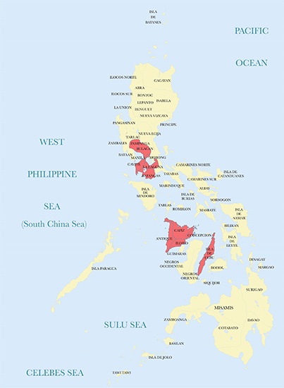
Not everyone could be elected, some had to be appointed, but on August 1, 1898, the ratification of the proclamation of Independence was formalized by representatives of Manila, Cavite, Laguna, Batangas, Bulacan, Bataan, Infanta, Morong, Tayabas, Pampanga, Pangasinan, Mindoro, Nueva Ecija, Tarlac, La Union, and Zambales. Butthe Visayas were left out, even though they were engaged in fighting Spain.
Share
First Ratification of the Proclamation of Independence, August 1, 1898
Fighting America in Cuba and the Philippines, both of which also had their own revolutionaries fighting them,Spain hoped European powers, particularly Germany, would come to its aid. Within days of the American victory in Manila Bay on May 1, 1898, the British, French, and Germans, all of whom had colonies in Southeast Asia, had sent warships to Manila Bay to see how things would unfold. The Germans, according to a French naval officer, at least, were particularly being relied on by the desperate Spaniards to come to their aid, but played coy, waiting to see if America would stay or go.
The Spanish forces in the Philippines collapsed. TheAmericans took Manila. Except for isolated pockets—in Baler, then in the province of El Principe, and in some towns in the Visayas—the Spaniards had surrendered. By September 15, 1898, Aguinaldo had convened the Malolos Congress and on September 29, 1898, the delegates to the Congress (a combination, again, of elected and appointed delegates—most were appointed) then ratified, for the second time, the June 12, 1898 proclamation of Independence. This time, formally at least, in the name of all the component provinces of the former Spanish colony of the Philippine archipelago.
But here’s something we often overlook. Through the composition of the Malolos Congress itself, and thus, the delegates who made the ratification,the Philippines of the First Republic was different from the Philippines of today. That’s because we should note the return in Malolos, for the last time, of a view of the Philippines extending beyond what we consider it to be today. You see, the delegates to the Malolos Congress included a certainRamon Arriola, who was appointed delegate for “the islands of Palaos,” which we could take to mean the entire Caroline Islands. Formally-speaking, at least,the Philippines as envisioned by the revolutionaries of 1898 extended to at the very least, Palau, and more likely, included, in their mental map, the entire Caroline Islands group, today’s Micronesia.
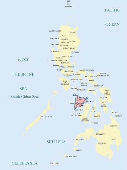
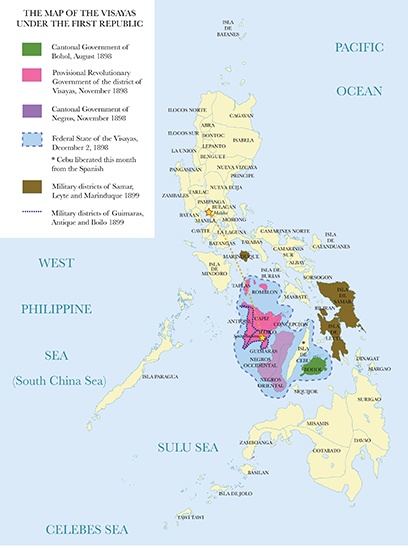
Aside from asserting Palau as part of the Philippines, two other things are worth noting. First, theMoro sultanates were included, but not because they sent representatives. For example,Benito Legarda, who was from Manila, was the appointed delegate for Jolo (Aguinaldo would try to rectify this, for example by inviting the Sultan of Sulu to join the Republic in January, 1899 but Aguinaldo’s letter was never answered). Second, the Visayans had been happily—and successfully—doing their own thing. By the time the second ratification of independence rolled around, the Visayas had theCantonal Government of Negros, theCantonal Government of Bohol, and theProvisional Government of the District of Visayas: All of which had fought Spain, but weren’t entirely keen on being under a central government. So while their membership in the First Republic was formalized by the Malolos Congress, the territory of these governments is marked with stripes because it wasn’t all that neat and tidy, then.
Share
Second Ratification of the Proclamation of Independence, September 29, 1898. The striped areas indicate the Visayas, included in the ratification, but which also had their own governments.
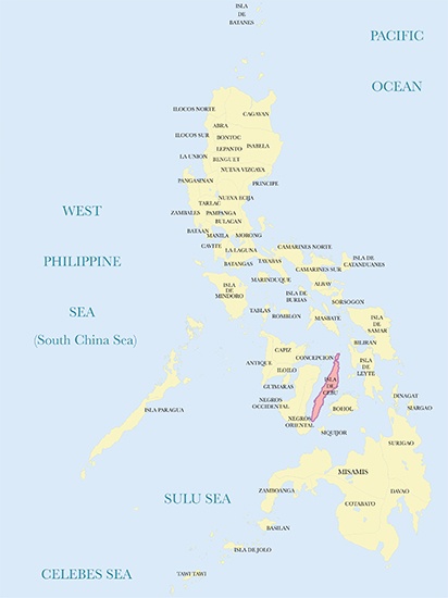
Thhis brings us to another thing we often entirely overlook:The different approach the Visayans took in fighting Spain and organizing themselves afterwards. Remember that Cebu had risen up in February 1898, even before Aguinaldo returned. Panay was organized and in full revolt by August 1898 when it became the Provisional Revolutionary Government of the District of the Visayas, which included by then the then-provinces of Tablas and Romblon. Bohol had also risen up in revolt in August, 1898. All this, even before the Malolos Congress was convened in September.
When the Malolos Congress was convened, these Visayan governments sent word they would recognize the Malolos Republic but on certain conditions.They wanted a Federal System; so while they would recognize Aguinaldo, they would have their own governments, collect their own taxes, and raise their own armies. By November 1898, Negros had risen up in revolt and organized itself into the Cantonal Government of Negros, and by December 2, 1898, they (Cebu, Bohol, Negros, Panay and its other component provinces) had all organized themselves into the Federal State of the Visayas to strengthen their case.
In the end, just as whatever setup was originally conceived of under the Malolos Constitution never fully operated, because the First Republic was by now engulfed in a war of survival against the United States, whatever relationship the Visayas really wanted was overtaken by military considerations. Two military districts—of Guimaras, Antique and Iloilo, basically covering the territory of the Federal State of the Visayas—and of Samar, Leyte and Marinduque, were organized by the Malolos government, with troops sent by Aguinaldo from Malolos to take charge. But the seed of Federalism had been planted, and continues to be a deeply-held belief among quite a few people to this day.
Share
The Visayas in the time of the First Republic, 1898-99: Showing the different states as they originally came into being, their union as a Federal State, and the military districts that overshadowed them.
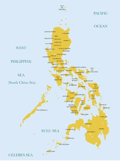
By 1901, though there would continue to be isolated pockets of resistance for years to come, the First Republic was gone, defeated, and destroyed. But aside from the flag, anthem presidency and Independence Day that are its most obvious legacies today, it also created our view of what the Philippines is: The map you see below.
Share
The Philippines under the First Republic. Don’t forget Palau!
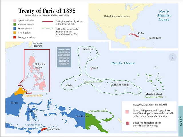
But even this map was the result of subsequent editing, so to speak. Remember Palau? The story of how our country came to be defined by the map you see above unfolded even as the First Republic was still fighting for its life. First, of course, wasthe decision of the United States and Spain to settle matters, ignoring the existence of our First Republic. The Philippines, as defined by the red bordered area below, was transferred to the United States, which also gained Puerto Rico and Guam. Cuba was given its independence, but as an American protectorate.
The year after, in 1899, its prize possessions gone, Spain let go of its remaining real estate by selling it to Germany. The Germans had acquired half of New Guinea in 1884, and the Marshall Islands in 1885. Buying up the Caroline Islands, Palau, and the Marianas (except for Guam, which had gone to the Americans) made perfect sense, so they did.
Share
The partitioning of the Spanish East Indies and the creation of the boundaries we recognize today, 1898-1900.
The British, for their part, so long as the Sultan of Sulu had been weak, and Spain too weak to be either a rival or a threat, had concentrated on placing North Borneo under their control, accomplishing this by 1882. With a new, vigorous power in the neighborhood, however, the British embarked on clarifying (and, along the way, strengthening) their claim by negotiating a treaty with the United States in 1900. It was this combination of actions:The American decision on what to acquire and not to acquire from Spain, and their willingness to establish borders with the British, that established the Philippines along the lines of what we consider the country to be today.
When Germany was defeated in World War I, its Pacific colonies were taken away and placed under the trusteeship of the League of Nations, which assigned control to Japan. When Japan lost World War II, these island groups in turn were placed under the trusteeship of the United Nations, which assigned control to the United States, until they achieved their present-day status.
Yet there’s one remaining footnote to this story of loss.A kind of echo of the Philippines that once was exists in the stories of our First Republic’s leaders as they were sent into exile by the Americans.Mabini himself with others, was exiled to Guam—which once upon a still recent time, had been considered part of the Philippines and which had been administered as part of the Archdiocese of Cebu. This marked, in a sense, the last in a line of Filipino exiles to the Marianas from 1872 when prominent Filipinos suspected of involvement in the Cavite Revolt of 1872—the revolt from which the whole idea of a Filipino people and nation is widely considered to have emerged from—had been sent there. It can be argued that those two batches of exiles, the first sent in 1872 to what was considered the remote outpost of the Philippines, and the last, sent in 1902 to what was no longer, and would never again, be a part of a now-disappeared definition of the Philippines, marks a story still waiting to be told. Of a geography that had lasted centuries, and which is now completely forgotten.
Several islands that the Spanish Galleon visited and traded with on the Pacific Ocean were considered part of Philippines during those times and this sea route became known as the Manila Acapulco Galleon Trade.
There are islands that appear and disappear in Philippines today.
Vanishing island refers to any permanent island which is exposed at low tide but is submersed at high tide. Vanishing islands occur globally. There are vanishing islands in the Philippines and several in the San Juan Islands. ... There is a vanishing island off the west coast of Samal Island in the Philippines.