The Castiglioni World Map is a perfect example of the official representation of the world after its circumnavigation by Magellan-Elcano in 1519-1522. It shows the technical and scientific advances in the art of cartography, and contributed to open a new era in the knowledge and expansion of the world in the sixteenth century. The map, also known as "Planisfero Castiglioni," is drawn on four sheets of vellum, measuring all together 82 x 214 cm. Although it is not signed, it is believed that the map was made by Diego Ribeiro(d. 1533), a cartographer working for the "Casa de Contratación" in Seville, the official agency that administered financial and legal overseas matters for the Spanish Empire.
(continue Article by clicking site...)
This map is known as Castiglioni World Map, for it was owned by the Castiglioni family until 2000, when it was purchased by the Italian state and assigned to the Estense Library in Modena, where it is currently held.
Cincinnati and Chillicothe are the only U.S. cities shown on the list in the video prior to the arrival of the Europeans in 1492. Please scroll to 1:36 in the video. Both cities were occupied by the Hopewell Indians and Adena Indians. Their population significantly grew large in 1420.
However the video should have also included Cahokia Mound, an urban center that grew extremely large around 1100 AD.
At the high point of its development, Cahokia was the largest urban center north of the great Mesoamerican cities in Mexico and Central America. Home to about 1,000 people before circa 1050, its population grew rapidly after that date. According to a 2007 study in Quaternary Science Reviews, "Between AD 1050 and 1100, Cahokia's population increased from between 1,400 and 2,800 people to between 10,200 and 15,300 people". an estimate that applies only to a 1.8-square-kilometre (0.69 sq mi) high-density central occupation area. Archaeologists estimate the city's population at between 6,000 and 40,000 at its peak, with more people living in outlying farming villages that supplied the main urban center.
As a result of archeological excavations in the early 21st century, new residential areas were found to the west of Cahokia; this discovery increased estimates of historic area population. If the highest population estimates are correct, Cahokia was larger than any subsequent city in the United States until the 1780s, when Philadelphia's population grew beyond 40,000. Its population may have been larger than contemporaneous London and Paris.
Located on the Oklahoma and Arkansas border, the Spiro Mounds were part of a city complex populated from 800 to 1450 A.D. At its peak, it supported a population of some 10,000 people.
Anthropomorphic human headed avian plate from Spiro
Map of the Caddoan Mississippian culture and some important sites
When did the lost city of Etzanoa exist?
Etzanoa is a historical city of the Wichita people, located in present-day Arkansas City, Kansas, near the Arkansas River, that flourished between 1450 and 1700. Dubbed "the Great Settlement" by Spanish explorers who visited the site, Etzanoa may have housed 20,000 Wichita people.
What is the story of Etzanoa?
Emerging research has found evidence of a mythical 20,000 strong civilisation called Etzanoa which sits in modern-day Arkansas City, Kansas. A Spanish horseshoe nail and a pockmarked iron ball fired from a European gun provided evidence of a battle between the Spanish and a local population of Native Americans.
Spring 2016: By David Malakoff.
In the early summer of 1601, Juan de Oñate, a conquistador who helped establish the Spanish colony of New Mexico, set off on a search to find Quivira, a fabled “city of gold.” Led by the lone survivor of an earlier expedition, Oñate marched east from his base near what is now Santa Fe with some 200 soldiers and several cannons, as well as a dozen priests and a large gaggle of camp followers. Along the way, the explorers encountered herds of American bison, marveling at these “most monstrous cattle” and the Apache hunters who stalked them. And they were among the first Europeans to describe the lush prairies of the Great Plains, with “grasses so high that in many places they hid a horse.”
Oñate’s most eye-popping discovery, however, was yet to come. That fall, his band reached a river located somewhere near what is now the Kansas-Oklahoma border. Its banks were lined with more than a thousand large, thatched-roof buildings, scattered among fields of corn, squash, and beans. Many of the inhabitants had fled before Oñate’s arrival, and astonished scouts reported that the town stretched on for miles. “The end of the houses was not in sight,” soldiers later told Spanish officials, estimating that some 20,000 people lived in the settlement they dubbed Etzanoa.
For centuries, many scholars discounted Oñate’s account of Etzanoa. Conquistadors had a reputation for exaggerating, they said, in order to impress their royal bosses and church officials eager to save souls. Archaeologists and anthropologists also were skeptical. Now, however, some recent archaeological discoveries—and some fresh translations of accounts of Oñate’s journey—may be changing that argument. Researchers say they have found preliminary evidence of Etzanoa in south-central Kansas near Arkansas City.
Another of North America’s “lost cities” has been found; the urban center—called Etzanoa by the Spanish—was home to some 20,000 Wichita Indians in southern Kansas.
Detection of scores of ancient ‘Star Mounds’ baffle archaeologists on Samoa. Samoa is in the South Pacific Ocean, and it has a tropical climate with thick rain forests and almost impassable volcanic ridges.
In 1988 doctors T. L. Hunt and P. V. Kirch from the University of Washington published An Archaeological Survey of the Manu’s Islands detailing the extensive excavations in American Samoa which were carried out by the multi-institutional Polynesian Culture History Programme in the 1960s. The Manuʻa Islands Group of American Samoa consists of three main islands: Taʻu, Ofu and Olosega and it is here that in the 1960s a series of ancient man-made structures were discovered known as Tia Seu Lupe, or Star Mounds. This extensive project revealed the islands “ three-millennium-long prehistory ” beginning with Early Eastern Lapita pottery, and somewhere in this 3000 year time span at a yet unknown time period the star mound builders got to work.
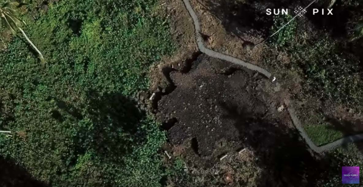
So, it has been known that the islands are dotted with the oddly shaped ‘star mounds’, but lidar scanning of the Savai'i of Samoa has just revealed the extent of the earthworks.
80 or so star mounds have been revealed on Samoa by lidar. (Tagata Pasifika / YouTube Screenshot)
And Now There Are 80 Of Them
A new archaeological project on Samoa using Lidar aerial scanning technology has revealed hundreds of overgrown structures including about 80 ‘Star Mounds’ located in difficult to access terrain. The sheer magnitude of the star mounds’ construction suggests they were very important structures to the cultures who used them and they are mostly constructed of earth and stone in of various sizes and shapes. Some of the seat mounds are faced with coral slabs and these larger level-topped platforms measure up to 40 meters (130 ft) in diameter and 5 meters (16+ ft) high.
The term “star mounds’ describes their geometric shapes which have usually five or eight projected arms so from above the mounds resemble how we draw stars. The largest star mound stands at the center of American Samoa’s Tiaseulupe Park but rather than having rays projecting outward is has two elevations with a combined length of 34 meters (111 ft) and a height of 3 meters (10 ft).
Snaring Birds or Gods?
Having described what star mounds are we must now ask a currently unanswerable question: what, were they used for? Firstly, most of the mounds are located across rough terrain and situated high up in mountains, and archaeologists state that the larger examples would have taken several years to construct, so their purpose must have been of the most exceptional importance to the builders.
The mound-builders of North America excavated hundreds of millions of basketfuls of earth which they piled up in impressive mounds for worship and sacrifices. However, deep in the South Pacific on the islands of Tonga, a Science-Frontiers article says native people created large mounds of earth for what “seems to be a frivolous purpose: pigeon-snaring”.
Early accounts tell of Samoan Chiefs who participated in the sport of pigeon catching and the English translation of “tia seu lupe” is “platform for netting lupe” - the large fruit-eating Pacific Pigeon. This prized food was a delicacy reserved for chiefs, who often gave them in ritual exchanges, but locals believe their star mounds probably held much greater social and ritual significance.
Assuming the mounds were “not” primarily used for catching pigeons, and that they did indeed have spiritual functions like those in North America, what or who might that worship have been focused towards? Samoan mythology is studded with a wide range of gods and goddesses, heroes and evil demons and a paper published by the University of Wellington titled ‘Myths and Legends of Ancient Samoa’ discusses: the Tree of Life , the peopling of the Earth, the Long Toothed Devil of Falelima, the war between the fish and the birds and the Story of the Sun and the Rain.
Might the mounds have been dedicated to worshiping multiple deities, like in North American cultures? According to a blog feature on glitternight.com ‘Tagaloa’ was the supreme ruler and the creator of the universe, the chief and progenitor of all other gods. ‘Gege’ cleared the Samoan island of Upolu of demons and ‘Papa’ the Earth goddess guarded the rocks beneath the islands, while ‘Foge’ and ‘Toafa’, the god and goddesses of springs, caused freshwater to magically emerge from the rocks.
Somewhat like the Christian story of God and Jesus, the chief Samoan deity, Tangaloa, sent the god of peace, Vavau, from the heavens down to the earth to bring peace to all humanity. But where American Samoan mythology differs from Christianity is that Vavau is said to still wander among humans trying to quell conflicts as they break out, while Jesus, after 2000 years, still promises to show up.
Top image: One of many star mounds now revealed on Samoa.


