Ancient Statue in the Azores Pointing Explorers to America
Video
Statue of Corvo
Present day map of Corvo island (Azores)Corvo IslandVolcanic rim of the island from the inside
The statue of Corvo was an equestrian statue which, according to Portuguese chronicles, was discovered on the island of Corvo by the first Portuguese explorers of the Azores. The statue was made of stone and was destroyed in the late 15th or early 16th century, as a result of a failed attempt to transport it to Portugal.
The statue was described by Damião de Góis as being in stone and standing on a slab. It depicted a man riding a horse.[1]The man was pointing towards the west, his right arm and index finger outstretched, while his left rested on the horse's mane.[2]The man wore a moorish tunic but no hat.[3]
Its plinth was inscribed with worn letters in an alphabet which was unknown to the early modern sailors who visited the island.[3][1]
The statue was located on the northwestern side of Corvo's mountain, in a location which de Góis describes as dangerous to access.[2]The area was so inaccessible that in their attempts to take copies of the writing on the plinth, Portuguese sailors were forced to use ropes to reach it.[2]
The statue is first mentioned in de Góis's Chronicle of Prince Dom Joăo of 1567, where it is described in detail.[4]The chronicle relates that King Manuel I sent the draftsman Duarte de Armas to make a sketch of the statue, which has not survived to the present day.[2]Upon seeing the drawing, the king sent a man from Porto to bring the statue to Lisbon.[2]However, by the time the statue arrived in Lisbon it was destroyed. According to de Góis this was likely caused by the attempt to move it.[2]Only the heads of the horse and man, the right arm of the man and a foot and section of the leg remained intact.[2]De Góis was unaware what had become of the pieces after their delivery to the king.[2]
Pêro da Fonseca, a sea captain who was in the islands in 1529, wrote that locals had informed him that an attempt had been made to take an impression of the letters beneath the statue.[2]Many of the letters were worn out, but wax impressions were taken of some of them, which could not be deciphered.[2]De Góis speculated that this was because the letters were too weathered, or that those who took the impressions knew only the Latin alphabet.[2]
Azorean priest Gaspar Frutuoso also mentioned the statue in his Saudades da Terra, repeating de Góis's story without the details of the attempt to copy the inscription.[4]
The origin of the statue is unknown and some authors consider it possible that the statue never existed.[3][1][2][4][5]
The possibility that the Carthaginians had built the statue was first raised by Gaspar Frutuoso in the 16th century,[2][4]however, Rodrigues and Costa argue that Frutuoso lacked any criteria to date the statue, even if it had existed.[4]Isserlin, writing in 1984, suggested that the statue may have had a Carthaginian origin, and pointed out that Carthaginian gods were often depicted on horseback, especially the solar deity Ba'al Hammon.[1]
Both Isserlin and a group from the Portuguese Association for Archaeological Investigation have associated the statue with the discovery of a trove of ancient Punic and Hellenic coins on Corvo in the 18th century.[2][1]The discovery followed a severe storm in 1749 which had disturbed sediments and uncovered a black pot in a ruined structure located on the beach.[2]Nine of the coins made their way to Swedish numismatist Johan Frans Podolyn, who identified seven of them as Carthaginian and two as being from Cyrene.[2][4]
Patricia and Pierre Bikai are more skeptical of the statue's existence. They point out that a 1367 map drawn by the Pizzigano brothers shows a figure with an outstretched arm in the vicinity of Corvo.[6]They state this figure is intended to show the limits beyond which navigation was impossible, but that this depiction gave rise to the idea that there was a statue on Corvo.[6]They also argue that a number of natural rock formations on the island have the superficial appearance of statues, which could have contributed to the growth of the story of the statue.[6]
The Portuguese explorers on the island of Corvo, Azores in 1432 discovered a free-standing statue of a man riding a horse pointing his index finger towards the Americas. This type of statue is referred to as the Equestrian Statue. The free-standing statue were commonly found during Roman and Greek times. Some stated that the Statue of Corvo was built by the Carthaginians. Whoever built it was suggesting that there were more lands towards the west and they had ships that crossed the harsh Atlantic Ocean.
I posted an excerpt from the article on the Equestrian Statue.
Anequestrian statueis astatueof a rider mounted on ahorse, from theLatineques, meaning 'knight', deriving fromequus, meaning 'horse'.[1]A statue of a riderless horse is strictly anequine statue. A full-sized equestrian statue is a difficult and expensive object for any culture to produce, and figures have typically been portraits of rulers or, in the Renaissance and more recently, military commanders.
Although there are outliers, the form is essentially a tradition inWestern art, used for imperial propaganda by the Roman emperors, with a significant revival inItalian Renaissance sculpture, which continued across Europe in the Baroque, as mastering the large-scale casting of bronze became more widespread, and later periods.
Statues at well under life-size have been popular in various materials, includingporcelain, since the Renaissance. The riders in these may not be portraits, but figures fromclassical mythologyor generic figures such asNative Americans.
A number of ancientEgyptian,AssyrianandPersianreliefsshow mounted figures, usually rulers, though no free-standing statues are known. The ChineseTerracotta Armyhas no mounted riders, though cavalrymen stand beside their mounts, but smallerTang dynastypottery tomb Qua figures often include them, at a relatively small scale. No Chinese portrait equestrian statues were made until modern times; statues of rulers are not part of traditional Chinese art, and indeed even painted portraits were only shown to high officials on special occasions until the eleventh century.[2]
Such statues frequently commemorated military leaders, and those statesmen who wished tosymbolicallyemphasize the active leadership role undertaken since Roman times by the equestrian class, theequites(plural ofeques) or knights.
There were numerousbronzeequestrian portraits (particularly of the emperors) inancient Rome, but they did not survive because they were melted down for reuse of the alloy ascoin,church bells, or other, smaller projects (such as new sculptures for Christian churches); the standingColossus of Barlettalost parts of his legs and arms to Dominican bells in 1309. Almost the only sole survivingRomanequestrian bronze, theequestrian statue of Marcus Aureliusin Rome, owes its preservation on theCampidoglio, to the popular misidentification ofMarcus Aurelius, the philosopher-emperor, withConstantine the Great, the Christian emperor. TheRegisole("Sun King") was a bronze classical or Late Antique equestrian monument of a ruler, highly influential during the Italian Renaissance but destroyed in 1796 in the wake of theFrench Revolution. It was originally erected atRavenna, but moved toPaviain the Middle Ages, where it stood on a column before the cathedral. A fragment of an equestrian portrait sculpture ofAugustushas also survived.
Equestrian statues were not very frequent in theMiddle Ages. Nevertheless, there are some examples, like theBamberg Horseman(German:Der Bamberger Reiter), inBamberg Cathedral. Another example is theMagdeburg Reiter, in the city ofMagdeburg, that depicts EmperorOtto I. This is in stone, which is fairly unusual at any period, though the Gothic statues at less than life-size at theScaliger TombsinVeronaare also in stone.
Ferdinand himself would be memorialized in 1608 with an equestrianstatue in Piazza della Annunziatawas completed by Giambologna's assistant,Pietro Tacca. Tacca's studio would produce such models for the rulers in France and Spain. His last public commission was the colossal equestrian bronze ofPhilip IV, begun in 1634 and shipped to Madrid in 1640. In Tacca's sculpture, atop a fountain composition that forms the centerpiece of the façade of the Royal Palace, the horse rears, and the entire weight of the sculpture balances on the two rear legs, and discreetly, its tail, a novel feat for a statue of this size.
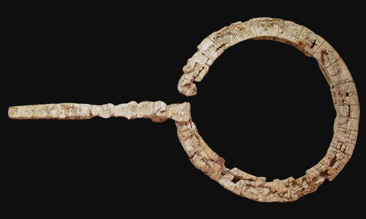
The ivory scepter with the longest Linear A inscription known, found in Knossos. Credit: A. Kanta et al.
A team of archaeologists has discovered in Knossos, on the Greek island of Crete, the longest Linear A inscription found to date. The script appears on a circular ivory object with an attached handle, discovered in a context of clear religious significance within a Neopalatial building. Besides providing the longest inscription in this yet-to-be-deciphered system, the find offers new perspectives on the use of Minoan writing in ceremonial contexts.
The object was uncovered in one of the rooms of a Neopalatial-phase building (1700-1450 BCE) located in the Anetaki plot, an area of Knossos characterized by its religious use from the Protopalatial period through later times.
The inscription was found in the so-called Ivory Deposit, a semi-subterranean structure where fragments of pottery, bronze, and other offering-related items were also discovered.
The ivory object, provisionally identified as a scepter or ritual staff, features an engraved inscription in the Linear A script on all its surfaces. According to specialists who have studied the find, the total length of the text reaches approximately 119 signs, surpassing in length all other known inscriptions in this writing system.
The object consists of an ivory ring with a handle, which originally seemed to be a single unit. However, epigraphic studies have shown that the inscription on the ring and the one on the handle exhibit stylistic differences, suggesting they were engraved by different scribes or at different times.
The text on the ring is distributed across four faces, each containing inscriptions carved with an unusually high degree of precision for Linear A writing. It is distinguished by its calligraphic refinement, which suggests a ceremonial rather than administrative use, unlike most clay tablets inscribed in this system.
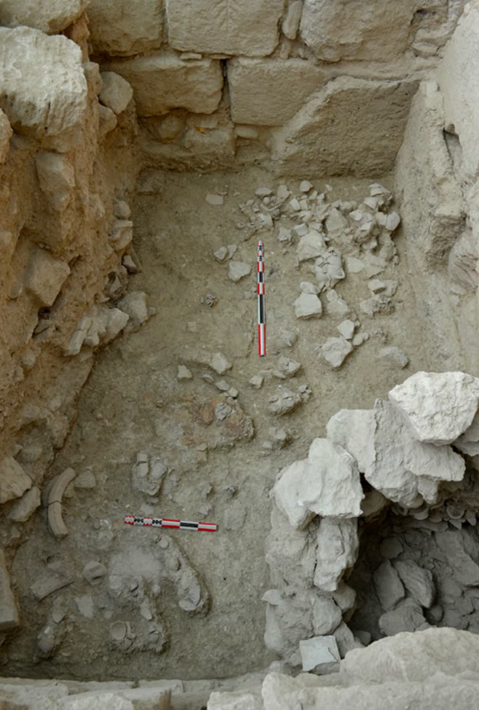
The site of the finding of the ivory scepter at Knossos. Credit: A. Kanta et al.
The inscription is divided into metopes or separate sections, within which logographic symbols representing animals, vessels, textiles, and hides appear, possibly relating to ritual activities.
One of the faces features a series of twelve quadrupeds, each within its own metope, suggesting an iconographic record of offerings or sacrifices.
Another face contains a sequence of syllabic and logographic characters, in some cases associated with vessel signs, which might indicate information about their contents.
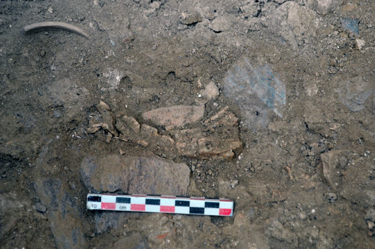
The ivory scepter at the time of the finding. Credit: A. Kanta et al.
Implications for the Study of Linear A
The discovery of this inscription provides an unprecedented opportunity to advance the study of Linear A, a writing system still undeciphered, which was used in Crete and other Aegean regions during the Bronze Age. Its length and the presence of ritual iconography suggest that it may be a ceremonial text or a record of offerings.
A particularly significant aspect is the absence of numerals, a feature that distinguishes this inscription from administrative texts on clay tablets. This reinforces the hypothesis that Minoan writing was not limited to accounting but also played a role in religious and ceremonial contexts.
On the other hand, the handle of the object bears a different inscription in Linear A, but with a structure more similar to administrative texts, including numerical and fractional signs. This could indicate a dual use for the object, combining ritual elements with a possible record-keeping function.
SOURCES
Kanta, A., Nakassis, D., Palaima, T. G., & Perna, M. (2025). An archaeological and epigraphical overview of some inscriptions found in the Cult Center of the city of Knossos (Anetaki plot). Ariadne, 27–43. doi.org/10.26248/ariadne.vi.1841
Charting the OLDEST Temple Pyramid Builders in the Americas!
Dating back to 3,500 BCE, uncover the earliest stone temple pyramids in the Americas—forgotten archaeological sites that predate the Pyramids of Giza! Join me as we explore the ancient ruins and temple pyramids of the of Norte Chico and Casma Sechin cultures, and discover features that may link them together. See how sites like Las Aldas and Aspero were integral to trade and sustenance for the ancient peoples living in these regions. Discover Pampa de Las Llamas-Moxeke, which redefined the age in which high functioning, socio-political civilizations originated. What forced these civilizations to vanish overnight? Was it a tsunami, El Niño, or a great flood referenced all around the word? With groundbreaking evidence reshaping history, this expedition reveals connections between lost cultures, advanced urban planning, and a trade network stretching across Peru!
Video
(Scroll to 11:55)
Narrator mentioned that the site in Sechin Bajo, Casma Valley was dated at 3,500 BCE which puts the date of the site 200 years older than Caral, the oldest known ancient structure in the Norte Chico area of Peru.
Here is the TRUE life of Christopher Columbus ! - History Documentary
Christopher Columbus is one of history’s most debated figures. Known for his voyages across the Atlantic, his legacy is a mix of groundbreaking discoveries, controversy, and myths. Born in Genoa, Italy, around 1451, Columbus grew up in a world where trade and exploration were becoming central to European ambitions. He spent years studying navigation and maritime routes, believing in a bold theory: reaching Asia by sailing west instead of taking the traditional eastern route around Africa. At the time, most scholars agreed that the Earth was round, but the actual size of the planet and the feasibility of such a journey were widely disputed. Columbus, convinced he could reach the East Indies faster than by traveling around Africa, sought financial backing for his expedition. After years of rejection from Portugal and other European powers, he finally gained the support of Spain’s King Ferdinand and Queen Isabella in 1492. That year, he set sail with three ships: the Niña, the Pinta, and the Santa María, heading into the unknown. After weeks at sea, Columbus and his crew spotted land on October 12, 1492. Believing he had reached islands off the coast of Asia, he had, in fact, arrived in the Caribbean. The lands he encountered were inhabited by indigenous people, whom he mistakenly called "Indians," thinking he had arrived near India. His arrival marked the beginning of European colonization in the Americas, an event that would reshape the world forever. Columbus completed four voyages across the Atlantic, exploring various parts of the Caribbean and Central America. Despite his growing fame, his rule over the territories he claimed for Spain was harsh, leading to reports of mismanagement and cruelty. Eventually, he was stripped of his titles and returned to Spain in disgrace. Columbus’s legacy is complex and deeply controversial. On one hand, he is celebrated for opening the Americas to European exploration, leading to cultural exchange, trade expansion, and the eventual rise of global empires. On the other, his expeditions led to the exploitation, enslavement, and suffering of indigenous populations. The Columbian Exchange brought new crops, animals, and technologies between Europe and the Americas, but it also introduced deadly diseases that devastated native communities. His actions continue to spark debates about how history should remember him. Some view him as a visionary explorer, while others see him as a figure of conquest and destruction. Over the centuries, the story of Columbus has been romanticized, with many myths surrounding his achievements. He did not prove that the Earth was round—this was already widely known among scholars of the time. Nor was he the first European to reach the Americas; Norse explorers, such as Leif Erikson, had done so centuries earlier. However, Columbus’s voyages had a lasting impact on world history, linking the continents in a way that had never been done before. His arrival marked the start of European dominance in the New World, setting the stage for centuries of colonization and migration. Today, Columbus Day is celebrated in various countries, though it has become a point of contention, with some calling for its replacement with Indigenous Peoples’ Day to recognize the suffering caused by European colonization. Historians continue to analyze Columbus’s actions, motivations, and consequences. He was a skilled navigator but also deeply ambitious and ruthless in his pursuit of wealth and power. His letters and journals reveal a man who sought both fortune and fame, often at the expense of those he encountered. While some of his contemporaries praised him for his discoveries, others criticized his governance and treatment of indigenous peoples. The Spanish Crown, initially supportive of his ventures, later distanced itself from him as reports of his harsh rule surfaced. His final years were spent trying to reclaim his lost titles and fortunes, but he died in 1506, largely disillusioned and without the recognition he had hoped for. In modern times, Columbus remains a symbol of exploration, ambition, and controversy. His name is attached to countless landmarks, cities, and institutions worldwide, yet his legacy is frequently reexamined in light of historical evidence. The impact of his voyages cannot be understated, as they marked the beginning of a new era of globalization, trade, and cultural exchange. However, the darker aspects of his expeditions—forced labor, violence, and the disruption of indigenous civilizations—cannot be ignored. As debates over historical figures continue, Columbus remains a figure whose story is told from multiple perspectives, each shaped by different interpretations of history.
Video
(Scroll to 49:56)
Christopher Columbus established the first small fort named La Navidad as early as December 24, 1492, on the Caribbean Island of Hispaniola which is today Dominican Republic and Haiti. The tropical island is inhabited by an indigenous people called the Tainos.
(Scroll to 56:46)
Christopher Columbus named the island Dominica in 1493
(Scroll to 57:18)
Christopher Columbus established the first European city on Hispaniola Island and named it La Isabella in 1493.
La Isabela
La Isabela. In 1493, Christopher Columbus built the first intentional European colonial town in the New World. It was intended as a base from which to establish Spanish presence and dominion in the Indies, and was Columbus's American home.
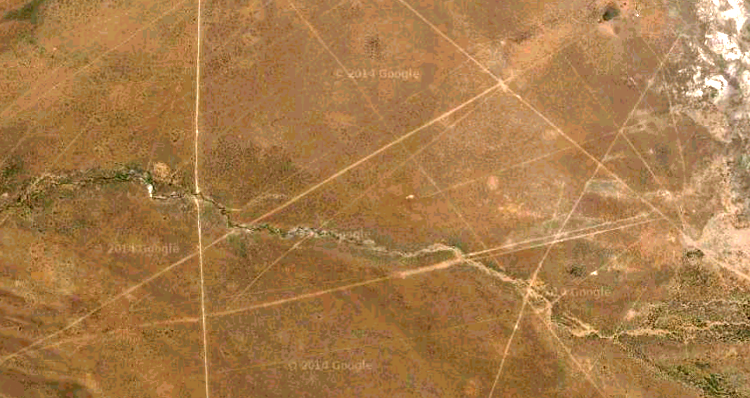
In a remote part of the Oruro department, in the shadow of Bolivia’s highest peak, lies what may be the world’s largest work of art.
The little known Sajama Lines are a network of thousands of near perfectly straight lines carved into the Earth as early as 3000 years ago by the indigenous population. The lines cover an area of 22,525 square kilometers, fifteen times larger than the Nazca Lines, and total an astonishing 16,000 kilometers in length.
The web of lines are thought to have been used as footpaths in pilgrimages and between the shrines, burial towers and villages constructed at their intersections. The motivation for their construction is not understood, however.
Likewise, it is unclear how the lines were created with such precision in the varied, uneven terrain. Each line is etched into the ground by removing the top soil and surface rock, exposing the lighter rock underneath. The individual lines measure 1-3 meters wide, and are up to 20 kilometers long.
The lines are located near the Nevado Sajama volcano, Bolivia’s highest point, and are best appreciated from the air or a high vantage point.
The Sajama Lines[saˈxama] of western Bolivia are a network of thousands (possibly tens of thousands) of nearly perfectly straight paths etched into the ground continuously for more than 3,000 years by the indigenous people living near the volcano Sajama. They form a web-like network that blankets the Altiplano.[1][2]
Recent research revealed that this network of lines covers an area of 22,525 km2 (8,697 sq mi; 5,566,000 acres), approximately fifteen times larger than the area covered by the Nazca Lines in Peru. Rough estimates put their linear length at approximately 16,000 kilometres (9,900 mi), roughly three times the breadth of the United States. As such, the Sajama Lines are the largest archaeological site in the Andes and might be considered the largest artwork in the world.[1][2]
The lines were created by scraping aside vegetation and the dark surface material consisting of soil and oxidizedrock and exposing the lighter subsurface material. Like the better-known Nazca Lines (which differ from the Sajama Lines in that some of the Nazca are depictions of animals) neither the purpose of these lines, nor how the makers achieved such precision, are completely understood.[1]
While many of these sacred lines extend as far as ten or twenty kilometers (and perhaps further), they all seem to maintain a remarkable straightness despite rugged topography and natural obstacles. The sheer number and length of these lines is often difficult to perceive from ground level, but from the air or hilltop vantage points, they are stunning.[1]
Many believe that the lines were originally used by indigenous people when they made sacredpilgrimages. Interspersed among this network of radial lines and aligned to where lines meet are wak'as (shrines), chullpas (burialtowers) and hamlets, making the area a unique cultural landscape. Though the region is now sparsely populated there is evidence that some of the lines are still in use as footpaths.[1]
In the 1970s, Britishwriter and filmmakerTony Morrison reported on this network of sacred lines and roadways. In recent years, organizations such as the Landmarks Foundation have studied and mapped the Sajama Lines to create a database to help protect the landscape from threats of erosion, unchecked internationally financed development and tourism in the area, and other dangers that come from the absence of a management plan.[1][2]
The Landmarks Foundation worked with the University of Pennsylvania to develop the "Tierra Sajama project" which used geographic information systems (GIS) and other analytic digital media tools to map, describe, and analyze the Sajama Lines and their associated structures in order to offer strategies to protect and promote the Lines in the future. The Tierra Sajama project:[1]
Created a computer-database of maps and pertinent information about the lines, local vegetation, and relevant topography
Analyzed and interpreted the patterns and meanings of various land features such as mountaintop shrines and religious structures to determine possible alignments to the sacred Lines
Developed proposals that provided for long-term protection of the Lines and enhanced appreciation of the sacred landscape
According to Tierra Sajama participants:
The Sajama Lines are extraordinary examples of human achievement and spiritual expression. With proper preservation and management, responsible development, erosion prevention and measures to minimize vandalism the Sajama Lines can be protected to the benefit of tourists from all over the world as well as the local people.[1]


.jpg)

.Magdeburger_Reiter.ajb.jpg)


_2_2013_February.jpg)


