Plato’s final hours recounted in scroll found in Vesuvius ash
Newly deciphered passages outline Greek philosopher’s burial place and describe critique of slave musician
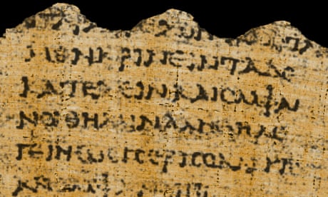
Newly deciphered passages from a papyrus scroll that was buried beneath layers of volcanic ash after the AD79 eruption of Mount Vesuvius may have shed light on the final hours of Plato, a key figure in the history of western philosophy.
In a groundbreaking discovery, the ancient scroll was found to contain a previously unknown narrative detailing how the Greek philosopher spent his last evening, describing how he listened to music played on a flute by a Thracian slave girl.
Despite battling a fever and being on the brink of death, Plato – who was known as a disciple of Socrates and a mentor to Aristotle, and who died in Athens around 348BC – retained enough lucidity to critique the musician for her lack of rhythm, the account suggests.
The decoded words also suggest Plato’s burial site was in his designated garden in the Academy of Athens, the world’s first university, which he founded, adjacent to the Mouseion. Previously, it was only known in general terms that he was buried within the academy.
In a presentation of the research findings at the National Library of Naples, Prof Graziano Ranocchia, of the University of Pisa, who spearheaded the team responsible for unearthing the carbonised scroll, described the discovery as an “extraordinary outcome that enriches our understanding of ancient history”.
He said: “Thanks to the most advanced imaging diagnostic techniques, we are finally able to read and decipher new sections of texts that previously seemed inaccessible.”
The scroll recorded the burial place of Plato as his designated garden at the Academy of Athens.Photograph: Nevena Tsvetanova/Alamy
The text also reveals that Plato was sold into slavery on the island of Aegina, possibly as early as 404BC when the Spartans conquered the island, or alternatively in 399BC, shortly after Socrates’ passing.
“Until now it was believed that Plato was sold into slavery in 387BC during his sojourn in Sicily at the court of Dionysius I of Syracuse,” Ranocchia said. “For the first time, we have been able to read sequences of hidden letters from the papyri that were enfolded within multiple layers, stuck to each other over the centuries, through an unrolling process using a mechanical technique that disrupted whole fragments of text.”
Ranocchia said the ability to identify these layers and virtually realign them to their original positions to restore textual continuity represented a significant advance in terms of gathering vast amounts of information.
AI helps scholars read scroll buried when Vesuvius erupted in AD79
Read more
He said the work was still in its nascent stages and the full impact would only become apparent in the coming years.
The scroll was preserved in a lavish villa in Herculaneumand discovered in 1750, and is believed to have belonged to Julius Caesar’s father-in-law.
Over the years, scholars have tried to decipher the scrolls found in this villa, known as the Villa of the Papyri.
Domenico Camardo, an archaeologist at the Herculaneum conservation project, compared the impact of the AD79 eruption on Herculaneum, an ancient Roman beach town close to Pompeii, to the dropping of an atomic bomb on the Japanese city of Hiroshima during the second world war.
Such was the heat of the pyroclastic surge produced by Vesuvius – believed to have been between 400C and 500C – that the brains and blood of victimsinstantly boiled.
Today Portugal has sunny cities, delicious food, wine, and stunning natural sceneries. However, in the fifteenth century, Portugal was the leading country in Europe for world exploration. During the fifteenth century, Portugal set the stage for discovering the new world.
The Portuguese were one of the first to colonize the Americas. Some old nautical maps even show that Portuguese sailors discovered the Americas before Columbus. The nautical charts suggest the Portuguese discovered the New World as early as 1424. Portugal successfully colonized South America and unsuccessfully attempted to colonize parts of North America (Newfoundland and Labrador and Nova Scotia in Canada).
Why Did Portugal Colonize?
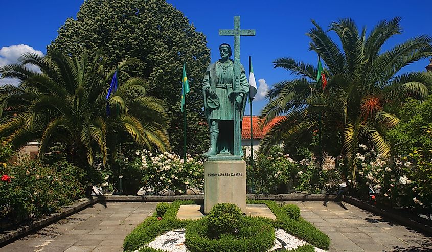
Garden and statue of Pedro Alvares Cabral, born in Belmonte. Image credit John Copland via Shutterstock
At the time, Portugal had many reasons for colonizing. One reason was to become more powerful. To increase their economic power as a country, colonization provided more opportunities. The Portuguese wanted to create more demand for their products. Portugal started colonies to trade for spices, gold, agricultural products, and other resources. There were also religious motives for Portugal’s colonization, such as spreading Catholicism.
The Treaty Of Tordesillas
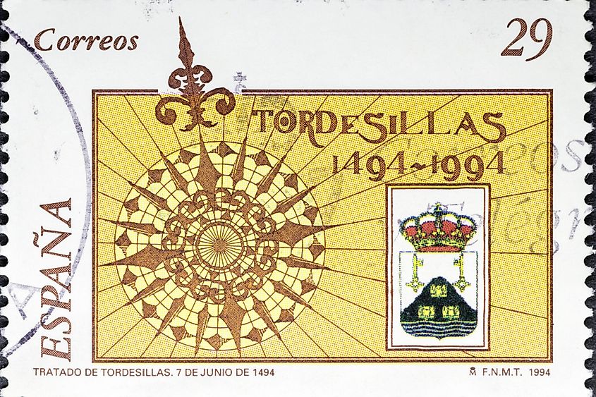
A vintage stamp printed in Spain shows the 500th anniversary of the Treaty of Tordesillas. Image credit Manuel Esteban via Shutterstock
The Treaty of Tordesillas was a treaty made on 7 June 1494, signed in Tordesillas, Spain. The Portuguese and Spanish Empires divided the newly discovered land outside Europe in the treaty.
A meridian of 370 leagues divided the Americas. Leagues were a unit of length in western Europe. In English-speaking countries, a nautical league is roughly equivalent to three miles. The line was between the Cape Verde islands, off the west coast of Africa, and modern-day Cuba and Hispaniola. Lands east of the Meridian belonged to Portugal. Although Spain and Portugal signed and respected the treaty, other European powers did not.
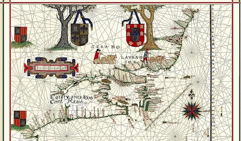
Map of Newfoundland and Labrador by Fernão Vaz Dourado in 1576. Image credit Creative Commons
Portugal was unsuccessful in colonizing North America. However, they did have influence over some communities in modern-day eastern Canada. The Portuguese crown claimed it had rights over the area in North America, explored by John Cabot from 1497 to 1498. John Cabot was an Italian explorer commissioned by the King of England who voyaged to the coast of North America. Based on terms from the Treaty of Tordesillas, the Portuguese had rights to parts of North America. Shortly after this, the Portuguese sailor João Fernandes Lavrador visited the Northeast Atlantic Coast, and Greenland.
In 1501 and 1502, the Corte Reál brothers explored and charted both Greenland and Newfoundland and Labrador. The Portuguese empire claimed Greenland and Labrador. Portugal founded a couple of colonies in Canada, including Portugal Cove-St. Philip's, Portugal Cove, and St. John's Island. Canada’s rich fishing opportunities incentivized Portuguese colonization. The abundance of fish prompted King Manuel I of Portugal to create a tax for cod fisheries in Newfoundland. Later, the Portuguese established fishing outposts in Newfoundland. However, Portugal abandoned these efforts to focus on colonizing South America.
Colonization Of South America
Remnants of defensive fortifications surrounding Colonia Del Sacramento, in the South American country of Uruguay. Image credit William Silver via Shutterstock
Portugal first discovered Brazil on a voyage headed by Pedro Álvares Cabral. When the ship landed on the coast of Porto Seguro on April 22, 1500, Cabral believed he landed on an island. He named the land Ilha de Vera Cruz (Island of the True Cross).
In 1508, Portuguese captains explored the River Plate estuary, in present-day Uruguay and Argentina. The Portuguese explored and colonized most of Brazil. By 1680 the Portuguese had gone southwards beyond Rio de la Plata, into what is known today as Uruguay.
Permanent residencies in Brazil by the Portuguese started in 1532. Martim Afonso de Sousa founded the city of São Vicente. However, the Portuguese established trade routes before permanent residency. They were exporting goods such as extracted brazilwood, used to dye European textiles.
Establishing Colonies In Brazil
Streets of Diamantina, UNESCO World Heritage Site, Minas Gerais, Brazil. Image credit Samuel Ericksen via Shutterstock
Between 1534 and 1536 there were fifteen captaincy colonies in Brazil. With the establishment of permanent colonies, the sugar cane industry started. To meet the labor-intensive demands of the industry the Portuguese used the slave trade. They used locals and later imported African slaves to grow cash crops such as sugar, tobacco, cotton, and coffee.
Philip II of Portugal decided to divide Brazil into two separate autonomous colonies in 1621, the State of Maranhão and the State of Brazil. From 1630 to 1654 the Netherlands attempted to take control of Brazil, but resigned, giving Brazil's colonies back to the Portuguese. The State of Maranhão changed to the State of Grão-Pará and Maranhão, in 1751. The state had a new capital and government. In 1772, Grão-Pará and Maranhão were spilt into two more states, the State of Grão-Pará and Rio Negro and the State of Maranhão and Piauí.
In 1775 all three Brazilian states, the State of Brazil, the State of Maranhão and Piauí; and the State of Grão-Pará and Rio Negro, merged into one. The states united as the State of Brazil and remained this way until colonization ended in Brazil. Portugal’s colonization lasted until 1822 when Portugal accepted the Brazilian Declaration of Independence.
Portugal had influence over some communities in the Americas and established many colonies in South America, particularly Brazil. The impacts of Portugal's colonization are still seen today in South America. The Portuguese created the largest commercial and maritime empire the world had ever seen, extending from South America to the Far East, and along the coastlines of Africa and India.
Montage of 8 pages (the third to sixth leaves) of the original 1375 Catalan Atlas
A part of the Majorcan map called "Catalan Atlas".
Catalan charts or Catalan portolans are portolan charts in the Catalan language. Portolan charts are a type of medieval and early modern map that focuses on maritime geography and includes a network of rhumb lines.[1]Most medieval portolan charts were made in Italian-speaking cities (mainly Genoa and Venice), with a substantial minority made in Catalan-speaking Majorca. In the 19th century, historians of cartography emphasized the differences of style and content between Italian and Catalan charts, but other authors have nuanced this distinction since then.
Differences between Italian and Catalan Portolans[edit]
Italian portolan charts tend to focus exclusively on coast lines, harbors and the open sea, whereas Catalan ones often shows information about the interior such as rivers. Catalan charts also tend to have richer decoration, with illustrations of cities, monarchs and animals.[
1439 portolan chart by Gabriel de Vallseca (Museu Maritim, Barcelona)
Portolan chart by Jorge de Aguiar (1492), the oldest known signed and dated chart of Portuguese origin (Beinecke Rare Book and Manuscript Library, Yale University, New Haven, USA)
In this video, we look at a simplified summary of the story ‘Lost Gold on the Old Spanish Trail,’ by Roman Malach, which appeared in the January 1975 issue of the magazine ‘Treasure’.
Video
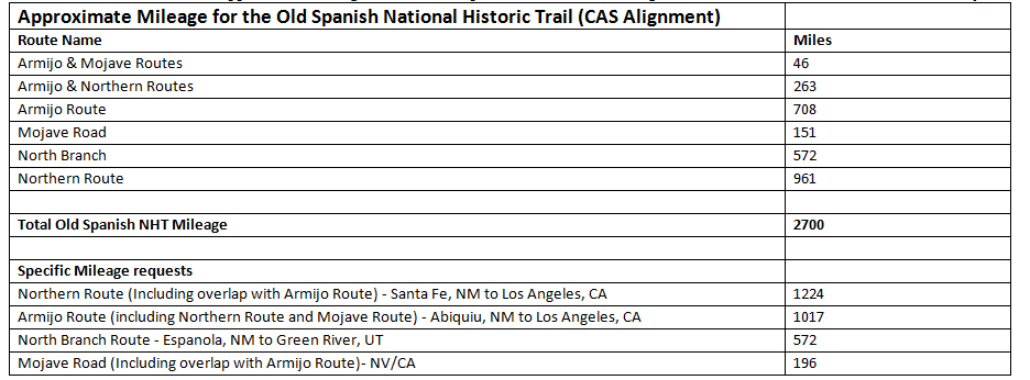
Old Spanish National Historic Trail
New Mexico, Colorado, Utah, Arizona, Nevada, California
Old Spanish National Historic Trail Map Courtesy of the National Park Service
After Mexico became independent from Spanish rule in 1821, trade flourished between the eastern part of the United States and the vast western territory. Networks of trails developed as explorers, traders and settlers attempted to find safe passage through the treacherous, dry, and scorching hot interior lands. The Old Spanish Trail developed during this period as westerners sought a way to connect the burgeoning trading post at Santa Fe to the riches of Los Angeles and southern California. First officially established in 1829, the main branch of the trail spanned over 2,700 miles, cutting through the southwestern corner of Colorado, moving north and west through Utah and finally turning south again toward Arizona and lower Nevada, with a terminus in Los Angeles, California.
Today, the National Park Service and the Bureau of Land Management jointly manage the Old Spanish National Historic Trail. The hazardous mule trade route stands as a testament to the epic story of the West, the struggles early frontiers-people faced in the transport of goods, and the critical ties between the international economics and cultures of North America’s opposite coasts in the mid-1800s. The Old Spanish Trail: History and Use
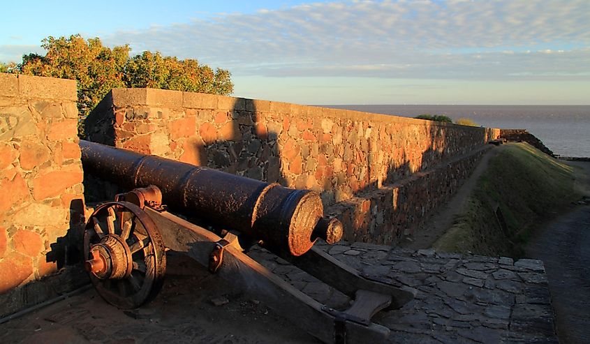
Antonio Armijo forged a route through the Mojave Desert on his way into Southern California. Pictured above: Trona Pinnacles in the Mojave Desert Courtesy of Matthew High, Flickr's Creative Commons
American Indians who lived in modern-day New Mexico, Colorado, and Utah were the first to devise systems of trails in the region for hunting, trade, and travel. As early as the mid-1700’s, Spanish explorers made amicable contact with native tribes and were guided along these paths as European trapping and trading increased in the area. Further Spanish attempts to connect the southern California coast to the growing trade center of Santa Fe failed due to the extreme terrain and weather.
Interest in finding a passage increased after the 1821 establishment of the Santa Fe Trail, which successfully connected the eastern United States with the New Mexico trading hub at Santa Fe. For centuries, Santa Fe had been a booming trading post between the North American interior and New Spain to the south. El Camino Real de Tierra Adentro, a popular wagon, immigration and trade road, had connected Santa Fe to Mexico City since the late 16th century. Both theSanta Fe TrailandEl Camino Real de Tierra Adentro National Historic Trailare also featured in this travel itinerary.
A route connecting Los Angeles and Santa Fe was finally established in 1829. Antonio Armijo, a Mexican merchant and trader, led 60 men and 100 mules across the wide expanse of the Colorado Plateau and forged a route through the Mojave Desert on his way into Southern California. Over the next two decades, Mexican and American traders developed variants of the route that Armijo pioneered, creating the multiple branches that make up the trail today. The trail’s routes allowed for much cultural interaction as peoples of different backgrounds showed interest in the various possibilities the new route provided. Spanish presidios and missions had long been in the area, and the trail between them helped strengthen their influence among native peoples and travelers alike. The trail hosted hardy, adventurous families looking to move westward in search of wealth and fertile farmlands, and also allowed passage for military missions, American Indian guides, and traders, as well as outlaws and raiders looking for vulnerable, weary travelers.
Antonio Armijo Public Domain Image
The Old Spanish Trail’s main use, however, was as an extensive trade route between the markets of Los Angeles and Santa Fe. Sheep and high quality woolen goods, such as serapes and blankets, were traded for a surplus supply of horses and mules raised on California’s ranchos. These valued stock animals commanded premium prices in New Mexico and on the western frontier of the United States. With its location on the west coast, Los Angeles also extended the North American markets across the Pacific Ocean, linking the continent’s interior to Asiatic trade for the first time.
Travel along the trail was not easy as the winding path skirted around the Grand Canyon, crossed through the continent’s largest arid sand dunes, and led travelers into the harsh deserts in Death Valley. Mules loaded with goods had to scramble up narrow paths, swim across creeks, and at times drag their handlers across roaring rivers. Despite the long, treacherous journey, the Old Spanish Trail remained an extraordinarily popular trade route until the Mexican-American War in 1848. With the United States’ victory, other wagon-friendly trade routes were developed, and the dangerous mule road was largely abandoned.
The Old Spanish Trail Today
Today, remnant traces of the trail remain where visitors can witness evidence of the route’s important impact on the West. Throughout New Mexico, Utah, and Colorado, expanses of packed and eroded ground still mark the road where hundreds of fast trotting mules and their tired muleteers once traversed the high country on their way to California.
The Palace of the Governors was built in 1616, making it the oldest continuously operational governmental building in the United States Courtesy of Partricia Drury, Flickr's Creative Commons
Santa Fe retains much of its historic fabric related to its days of major western trade. The Santa Fe Plaza at the center of town was once a teeming hotspot for trade and social interaction as it is today. The plaza is aNational Historic Landmarklisted in the National Register of Historic Places. It buildings constructed in the Pueblo, Spanish, and Territorial styles reflect the diverse cultural history of Santa Fe. The Palace of the Governors on the north side of the Plaza is well worth a visit. Built in 1610, it is the oldest continuously occupied governmental building in the United States. Today, the palace is aNational Historic Landmarkand a museum.
The Old Spanish Trail Associationis the main independent partner of the Old Spanish Trail, working with the National Park Service and Bureau of Land Management. The association’s website features extensive information regarding trail visitation, including interactive maps, locations of interpretive plaques, local points of interest, and the answers to frequently asked questions.
The trail hosted hardy, adventurous families looking to move westward in search of wealth and fertile farmlands, and also allowed passage for military missions, American Indian guides, and traders, as well as outlaws and raiders looking for vulnerable, weary travelers.
How long did it take to cross the Old Spanish Trail?
Carrying up to 400 pounds of merchandise, mules traveled the approximately 2,700 mile trail (round trip), in caravans of 50 – 200 animals. Traveling 12 – 15 miles per day, a round trip would take from 180 – 225 days, assuming that nothing went wrong along the way.
How many miles was the Old Spanish Trail?
Old Spanish National Historic Trail extends 2,700 miles across New Mexico, Colorado, Utah, Arizona, Nevada, and California. Jan 13, 2020
Why did people go on the Old Spanish Trail?
There was very little east-west traffic at the time — most travel was north and south — and the Old Spanish Trail opened up access. But that access also meant human cargo could be exchanged along this route, which also provided smugglers a means of escape.
Why did the Old Spanish Trail have multiple routes?
The traffic in human beings reverberated among the peoples who lived along the trail for many years longer than the caravans plied their trade. People made use of the Spanish Trail for a variety of purposes, which over time led to the development of several main routes and numerous alternates.
What were the challenges of the Old Spanish Trail?
The trips were arduous. Dramatically changing terrain and climate posed major challenges. Caravans lost their way, suffered from thirst, and were forced to eat some of their pack mules when supplies ran out. Animals also suffered in the harsh desert environment and endured severe weather.
What people experienced along the way of the Old Spanish Trail?
People who made the journey traveled across mountains, deserts, canyons and other types of tough terrain on the over 2,500-mile route which passed through six states. Mule caravans would make their way through this area, transporting woolen goods and other items.
What Native American tribes were on the Old Spanish Trail?
The Old Spanish National Historic Trail utilized an existing network of Indian trails. The Utes, Pueblos, Jicarilla Apaches, Hopis, Navajos, Paiutes, Mojaves, and Chemehuevis knew these routes long ago.
When was the Spanish trail used?
Mexican trader Antonio Armijo led the first commercial caravan between Abiquiú, New Mexico and Los Angeles, California in 1829. Versions of this route were then used by traders and settlers in the region for the next two decades on what eventually came to be known as the Old Spanish Trail. Jun 29, 2021
What name did Spanish traders give their resting spot?
In the context of El Camino, parajes were places where people would stop and rest during their journey. Parajes were also places where people came together, exchanging goods and news. Many of these rest stops evolved and towns developed around El Camino trade. Aug 8, 2022
What bodies of water does the Old Spanish Trail cross?
This is the so- called "Old Spanish Trail to California ", which is indicated as passing through Abiquiu and northwest down the Dolores and across Grand and Green rivers, thence west to the Sevier, and southwest to the Virgin and Mohave rivers and through Cajon Pass to Los Angeles.
What year did the Old Spanish Trail become recognized as a national historical trail?
2002
The Old Spanish National Historic Trail
Bush signed the bill early in December 2002. The Old Spanish Trail linked two provinces of Mexico separated by such difficult topography and climatic extremes that, despite attempts beginning as early as 1776, a route was successfully opened only in 1829.
Aug 31, 2023
What are some interesting facts about the Old Spanish Trail?
It is considered one of the most arduous of all trade routes ever established in the United States. Explored, in part, by Spanish explorers as early as the late 16th century, the trail saw extensive use by pack trains from about 1830 until the mid-1850s. The name of the trail comes from the publication of John C.
Where did the Old Spanish Trail go?
The Old Spanish Trail largely follows what became, in 1927, U.S. Highway 90 east of San Antonio and U.S. Highway 80 west of Scroggins Draw, Texas. Between San Antonio and Scroggins Draw, it follows portions of U.S. Highway 87, Texas State Highway 27, and a pre-1991 alignment of U.S. Highway 290.
What did Spain call America?
las Indias Occidentales
Until well into the 1700s, the Spanish most commonly referred to the Americas as 'las Indias Occidentales'. They also commonly used the name 'Tierra Firme' for the mainland part of the Americas.
What did people eat on the Old Spanish Trail?
Food for the journey had to be dried and gathered along the way. While jerky, piñon nuts, berries, and posole are enjoyable treats for many of us today, eating these foods day after day for months would not be desirable.
Blue and Green colors are rarely seen on pictographs in the Southwest. The blue image below is the rarest color while the red image is the most common. The Amerindian pictograph is located in Joshua Tree National Park, Southern California.
Regional-Specific Colors
Blues and greens, which are rare in Southwestern pictographs, are largely restricted to regions with outcrops of the green and blue copper carbonate minerals malachite and azurite. Malachite pigments are fairly stable, but those of azurite are not. Because slow, natural oxidation converts azurite into malachite, most of the blue, azurite-based pigments in pictographs have turned to green.
Hematite Headlines Pictographs
The bright red strata in these formations near Mexican Hat, Utah, consist mainly of particulate hematite. Hematite, an abundant iron oxide, was the primary red pigment used in pictograph paints worldwide.
The predominant pictograph color is red, which is not surprising considering its high visual impact and the plentiful supply of the hematite, or iron oxide. While the color of crystalline hematite is silvery-gray to near-black, that of particulate hematite is red. The finer the hematite particles, the more intense and bright is their red color. Hematite is chemically stable, impervious to the action of natural acids, and does not fade in sunlight. Red hematite pigments were used extensively in pictographs around the world, most notably in the famed, 30,000-year-old Neolithic cave paintings of southern France.
Black, the next most common pictograph color, is derived from pigments of elemental carbon obtained from fireplace soot or finely ground charcoal or coal. Some black pigments consist of finely ground pyrolusite (manganese dioxide) or similar manganese oxides or hydroxides. Both elemental carbon and manganese oxides are chemically stable and produce jet-black paints.
White pictograph paints contain finely ground white clays, seashells, bones, gypsum (hydrous calcium sulfate), and caliche (a natural calcium-carbonate cement that often coats rocks in arid regions). White pictograph pigments had varying degrees of chemical stability.
An occasional pictograph color is yellow, which is based on a pigment of limonite or ocher, an abundant mixture of hydrated iron oxides.
What is so special about Joshua Tree National Park?
With elevations ranging from 900 feet to over 5,000 feet above sea level, the park is home to a diversity of biological communities found nowhere else in such proximity. Sand dunes, dry lakes, flat valleys, extraordinarily rugged mountains, granitic monoliths, and oases are all found within its nearly 800,000 acres.
What is the indigenous name for the Joshua tree?
The local Cahuilla have long referred to the tree as “hunuvat chiy'a” or “humwichawa;” both names are used by a few elders fluent in the language
What is the most scenic part of Joshua Tree?
Keys View is one of the best viewpoints in Joshua Tree. It's at the end of a spur road off of Park Boulevard, but it's worth the short detour. Without any hiking required, you'll get amazing views over the vast Mojave Desert
Is Joshua Tree worth the hype?
In conclusion, Joshua Tree National Park offers a captivating blend of natural beauty, unique landscapes, and intriguing wildlife. Whether you're drawn by the wildflower blooms, the Petroglyphs, the Cholla Cactus Garden, or Skull Rock, there's something here for everyone to enjoy.
Who were the first people in Joshua tree?
Native Americans
The park is located within the traditional territories of several indigenous tribes, including the Pinto Culture, the Serrano, Cahuilla, and Chemehuevi. The Pinto Culture were the first known inhabitants of Joshua Tree and lived in the area as early as 4000 BCE.
Jan 2, 2024
1994
Joshua Tree was designated a National Monument in 1936 by President Franklin Delano Roosevelt and accorded National Park status in 1994.


