Tags
Tab Item Content
Join Us!
Archives Meta
Notifications
Clear all

Architecture Archaeological Wonder in Philippines

10 Posts
4 Users
8 Likes
2,358 Views
Flower Girl
Posts: 889
Topic starter
(@flower-girl)
Member
Joined: 5 years ago
The Ijangs - Archaeological Wonder in Batanes [Philippines]


What are these, and how did they serve the precolonial island inhabitants?


Derived from the Ivatan word “idi”, a variant of “ili”, ijang literally means refuge, mountain fortress, or a village or town. Ijangs were first described by English navigator, Captain William Dampier, who visited Batanes in 1687. He mentioned the presence of house terraces reinforced by dry stonework, which were accessible only by ladders from below.
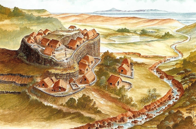


ijang is a fortress strategically located on a rocky elevated landscape, usually on hilltops or ridges.
Reconstructed artist’s concept of Savidug iiang. (Photo courtesy of Dr. Eusebio Dizon)


An ijang is a fortress strategically located on a rocky elevated landscape, usually on hilltops or ridges. It is protected by naturally occurring steep cliffs and may occur inland or on coastal areas. Precolonial Ivatans took refuge in these structures from aggressors whom they hurled down with rocks. According to the late Ivatan cultural historian, Dr. Florentino Hornedo, every known Ivatan community had an ijang, built because of prolonged defensive stance against enemies, usually from hostile clans. 


This ijang located in Savidug is considered the most impressive of all the Batanes ijangs, rising like a drum at about 40 m high above the land plane
This ijang located in Savidug is considered the most impressive of all the Batanes ijangs, rising like a drum at about 40 m high above the land plane, and 63 m above mean sea level. (Photo courtesy of Dr. Eusebio Dizon)


At least 21 ijang sites were archaeologically documented throughout the islands of Batan, Sabtang, Itbayat and Ivuhos, first by Japanese researchers from the University of Kumamoto in 1982, then by the #NationalMuseumPH led by Dr. Eusebio Dizon beginning in 1994. Excavations revealed that aside from being defensive structures, the sites were primarily used for habitation.
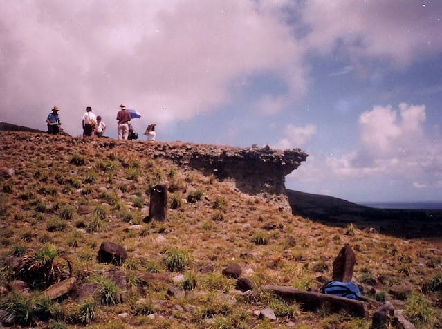


team conducting a site survey at Savidug ijang site
The National Museum of the Philippines team conducting a site survey at Savidug ijang site in 1994. (Photo courtesy of Dr. Eusebio Dizon)


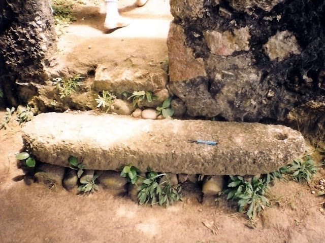
Batanes ijangs can also be characterized by the presence of these perforated stone pillars
The Batanes ijangs can also be characterized by the presence of these perforated stone pillars. While the exact use of these stones has not yet been fully determined, it is believed that they were used as structural materials for houses or house posts (Photo courtesy of Dr. Eusebio Dizon)


The Savidug ijang, located at about 1.2 km southwest of Savidug village in Sabtang Island, is one of the most extensively studied ijang sites. Evidences of human settlement were found in this 10th to 14th century sites, such as postholes, stone wall foundations, perforated stone pillars, and indication of ripraps. Artifacts like glass beads, red-slipped pottery, and ceramic wares from the Song and Yuan dynasties were also recovered.


The ijang served as a defensive fortress for precolonial Ivatans
The ijang served as a defensive fortress for precolonial Ivatans, built on elevated grounds and protected by steep cliffs. (Photo courtesy of Dr. Eusebio Dizon).


Meanwhile, some of the terraces surrounding the habitation areas were used for agricultural purposes, as they were determined to be suitable for planting camote and other traditional crops. By the early 18th century, Spanish colonizers forced the locals to abandon these hilltop settlements to transfer permanently into pueblos or town centers for their more effective administration.


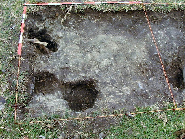
Several postholes found at the Savidug ijang
Several postholes found at the Savidug ijang that served as archaeological evidence of human settlement in the area. From the 2013 publication “Archaeological Excavations at Savidug, Sabtang Island” in 4000 Years of Migration and Cultural Exchange: The Archaeology of the Batanes Islands, Northern Philippines by Peter Bellwood and Eusebio Dizon.


Dr. Grace Barretto-Tesoro of the Archaeological Studies Program at the University of the Philippines noted in her 1999 study that the concept of hilltop settlements is a common cultural feature among Austronesian societies. There are still remnants of ijangs around Batanes today. If not covered with overgrown vegetation, they are usually utilized by the locals as pasture. Try to look for these precolonial settlements’ ruins when you visit the NMP Batanes Area Museum in Uyugan. Now classified as Modified General Community Quarantine (MGCQ) areas, our facilities remain open to welcome visitors, following properly observed health and safety guidelines.


Stone Sinkers Excavated from the Batanes Islands


Stone Sinkers Excavated from the Batanes Islands


Simple, non-striking, and unimportant stones? Let’s find out.


A stone sinker varies in size and functions as an anchor, plummet, or weight for nets and fishing lines. Its form can be modified into oval, spherical, triangular, rectangular, or donut-like shapes. Usually notched, perforated, or grooved sinkers are stone tool artifacts recovered from archaeological sites across the globe, particularly in wetland, dried riverbed/stream, coastal areas, or within a nearby water source. It is a fishing technology that dates to the Upper Paleolithic Period (circa 40,000–30,000 Before Common Era or BCE) as evidenced by the discovery of 29,000-year-old stone sinkers in the Maedun Cave in Gangwon Province, South Korea.


Comparison of stone sinkers from Batanes and Taiwan
A comparison of the excavated stone sinkers from the Batanes Islands and Taiwan. Image from the 2013 monograph “4000 Years of Migration and Cultural Exchange: The Archaeology of the Batanes Islands, Northern Philippines”, edited by Dr. Peter Bellwood and Dr. Eusebio Dizon.


In the Batanes Islands, stone sinkers were recovered in 1982 by researchers from the Kumamoto University of Japan, and during the 2002–2007 archaeological activities in the islands of Batan, Sabtang, and Itbayat. 


Stone Sinkers Excavated from the Batanes Islands


The 2002–2007 Batanes fieldwork was a collaborative research project that involved the #NationalMuseumPH, Australian National University (ANU), and the University of the Philippines’ Archaeological Studies Program, along with representatives from partner academic institutions. The stone sinkers from Batanes excavated in the 2000s at the Savidug Dune Site in Sabtang Island and Sunget Site in Batan Island, were mostly notched on opposite sides, and dated to the Neolithic Period—1,100 to late first millennium BCE and 1,200 to 800 BCE, respectively.


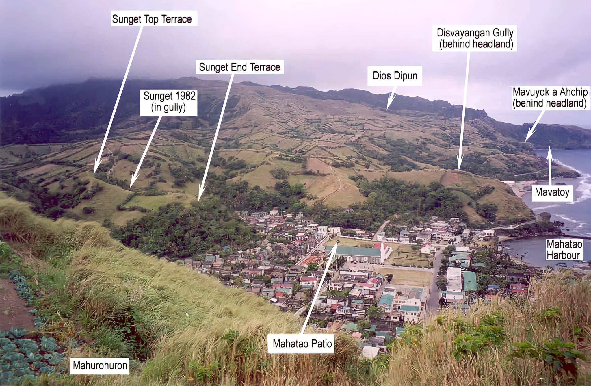
View of the Sunget Sites (upper-left) where the stone sinkers and other artifacts were excavated. The photograph shows the open location of the archaeological sites, the Municipality of Mahatao, and other locations on Batan Island. Image from the 2013 monograph “4000 Years of Migration and Cultural Exchange: The Archaeology of the Batanes Islands, Northern Philippines”, edited by Dr. Peter Bellwood and Dr. Eusebio Dizon.


In her 2006 master’s thesis, “Fishing Sinkers in the Batanes Islands (Philippines) and Taiwan, and Further Relationships with East Asia”, Shawna Hsiu-Ying Yang explains the similarity in form between the Sunget Site pebble sinkers and those found in Taiwan’s early Neolithic (i.e. Dapenkeng culture) sites prior to 2,500 BCE. The sinkers’ likeness suggests that the early inhabitants of Batanes possibly came from Taiwan, bringing with them the knowledge of manufacturing pebbles as sinkers, which endured on the island until around 2 millenniums ago. 


Mapping activity at Sunget Site (Sunget Top Terrace) led by Dr. Peter Bellwood with some of the team members
Mapping activity at Sunget Site (Sunget Top Terrace) led by Dr. Peter Bellwood with some of the team members. Photo by A de Leon (2003).
The excavation area at Savidug Dune Site in Sabtang Island, situated on an 8-m high cliff fronting the sea
The excavation area at Savidug Dune Site in Sabtang Island, situated on an 8-m high cliff fronting the sea. Photo by Dr. Julien Corny (2007).


Furthermore, the excavation of side-notched pebble sinkers and a Fengtian nephrite lingling-o within the same cultural layer in Savidug Dune Site archaeologically supports the cultural connection between the Philippines and Taiwan, as noted by Dr. Hsiao-chun Hung of ANU and Dr. Yoshiyuki Iizuka of Academia Sinica.



illustration of a stone sinker
An illustration of a stone sinker and its probable method of attachment as a net weight. Image by Mr. Larry Porter of University of Arkansas System – Arkansas Archaeological Survey and retrieved from his 2020 webpage article “Notched Stone Net Sinkers” ( https://archeology.uark.edu/artifacts/netsinkers/ )


Beyond the stone sinker’s plain look is an indispensable and relevant archaeological piece in reconstructing people’s lifeways, interactions, and movements in the past, indicative of how the sea and ocean are linked with their lives.


Some of the side-notched pebble sinkers along with other artifacts from the Batanes Islands are on display at the “Palayok: The Ceramic Heritage of the Philippines” exhibit.

The Ijangs - Archaeological Wonder in Batanes [Philippines] - yodisphere.com

Reply
9 Replies
Prau123 avatar
Posts: 2520
(@prau123)
Famed Member
Joined: 5 years ago

Thanks for sharing this article. One reason why we see more archaeological architectures and artifacts in the north compared to the south and central Philippines is because the landscape in the north such as Batanes have more open fields in comparison. There's probably some ancient structures and artifacts to be found in the southern and central parts of the Philippines but a lot of them have been devoured by the tropical rainforest jungle and soil erosion. 

Reply
Elgin Productions
Posts: 351
(@elgin)
Reputable Member
Joined: 5 years ago

The Chocolate Hills (Cebuano: Mga Bungtod sa Tsokolate, Tagalog: Tsokolateng burol) are a geological formation in the Bohol province of the Philippines.[1] There are at least 1,260 hills but there may be as many as 1,776 hills spread over an area of more than 50 square kilometres (20 sq mi).[2] They are covered in green grass that turns brown during the dry season, hence the name.

The Chocolate Hills is a famous tourist attraction of Bohol. They are featured in the provincial flag and seal to symbolize the abundance of natural attractions in the province.[3] They are in the Philippine Tourism Authority's list of tourist destinations in the Philippines;[4] they have been declared the country's third National Geological Monument and proposed for inclusion in the UNESCO World Heritage List.[4]

Reply
1 Reply
jason
(@jason)
Joined: 5 years ago

Prominent Member
Posts: 813

@elgin 

I've been here before very beautiful place

Reply
Prau123 avatar
Posts: 2520
(@prau123)
Famed Member
Joined: 5 years ago

So are the Chocolate Hills human made or natural?  Is the area actually an ancient city covered in vegetation?  

Reply
2 Replies
Flower Girl
(@flower-girl)
Joined: 5 years ago

Member
Posts: 889

@prau123 

probably volcanic eruption

Reply
Prau123 avatar
(@prau123)
Joined: 5 years ago

Famed Member
Posts: 2520

@flower-girl 


yeah, it appears that way for some scientist but I really do not see a volcano in the background. 


Here's a tidbit.


Is there a volcano in Bohol?


The island, roughly oval in shape, lies between the Camotes Sea (north) and the Bohol Sea (south). Its volcanic core is mostly covered with coralline limestone.


Reply
Flower Girl
Posts: 889
Topic starter
(@flower-girl)
Member
Joined: 5 years ago

Origin of the Chocolate Hills on Bohol

Geologists and scientists have long been puzzled over the formation of the Chocolate Hills. In principle, there is no clear explanation recognized by all geologists, but only plausible (and less plausible) hypotheses and theories.

The simplest explanations are based on the fact that the Chocolate Hills were created, in particular, by limestone weathering, volcanism and plate tectonic elevations of the seafloor.


Volcanic Eruption Theory on Emergence

One of the circulating theories says that the origin of the Chocolate Hills is due to a huge volcanic eruption, in which a prehistoric mountain of fire spewed out gigantic stone blocks. The stone blocks lying in the water were finally lifted up out of the sea by terrestrial movements. According to this theory, the Chocolate Hills received their astonishingly symmetrical shape particularly from the influence of ebb and flow.


Theory on the Bronze Plaque in Carmen

A bronze plaque, which can be found on the observation deck in the municipality of Carmen, is based on a completely different, more plausible theory. According to this, the Chocolate Hills were supposed to have been coral reefs that were lifted out of the ocean by a tremendous tectonic movement. Rain, wind and erosion finally gave the chocolate mounds their unique, admirable shape today.

The bronze plaque says: “The unique land form known as the Chocolate Hills of Bohol was formed ages ago by the uplift of coral deposits and the action of rain water and erosion.”

And further: “The grassy hills were once coral reefs that erupted from the sea in a massive geologic shift. Wind and water put on the finishing touches over hundreds of thousands of years. “


Legends About the Origin of the Chocolate Hills

Where science cannot offer a 100% clear explanation, there are of course some legends and myths about the origins of the Chocolate Hills (especially among superstitious Boholanons). A common legend says that the Chocolate Hills used to be a battlefield for two giants who had fought over huge stone blocks for several days. When there was still no winner after days of fighting, the two giants became exhausted and left Bohol – of course without having cleaned up their battlefield before they left.


Arogo and Aloya

Another myth tells the romantic story of the giant Arogo and the mortal chief’s daughter Aloya. Arogo fell head over heels in love with her. But when she died, the giant’s heart broke and Arogo shed bitter tears. His huge tears, half of which were stuck in the ground, turned into hills and form the Chocolate Hills today, testifying to Arogo’s great grief.


Dano and Eng

The legend of Dano and Eng is also well known: Dano, a fat giant, devoured everything he could get his hands on. When he saw the charming young woman Eng and fell in love with her on the level where the Chocolate Hills are today, he decided to lose weight massively: he eliminated everything that he had previously devoured. His excretions eventually covered the entire level. In the end, Dano gained Eng’s attention through his blatant weight loss.

Reply
Page 1 / 2