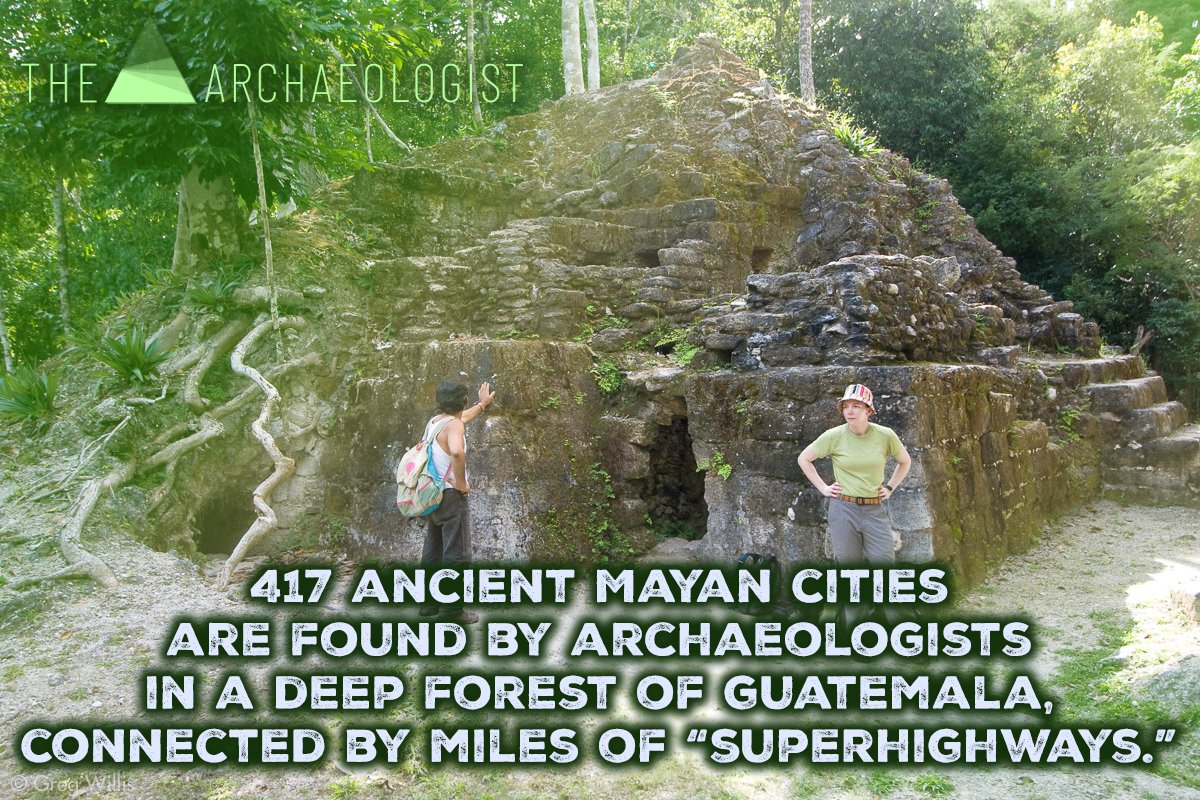
417 prehistoric Maya cities are found by archaeologists buried in isolated forests, connected by miles of "superhighways," in a vanished universe. The "first motorway system in the world" is what scientists are referring to.
Researchers from a joint US-Guatemalan archaeological study revealed in an interview with The Washington Post that they had discovered 417 cities with an estimated 3,000-year history that were connected by 110 miles of "superhighways."
This finding is causing historians to reevaluate their understanding of the ancient Mayan civilization. According to the Post, the finding of a network of cities and highways, hydraulic systems, and agricultural infrastructure indicates that societies in Central America were more developed than previously thought.
These findings "reflect socio-economic organization and political power," the research claims.
The Mayans, who were formerly thought of as a nomadic, hunter-gatherer culture, lived in the pre-classic era, which dates back to 1,000 B.C., during which time the lost world first appeared.
According to Richard Hansen, the main author of the paper and adjunct research professor of archaeology at Idaho State University, this find from the El Mirador jungle region in southern Guatemala is a "game changer."
On the border between Mexico and Guatemala, the discovery was made in a remote tropical jungle. According to the Post, the difficult 40-mile journey through the deep, jaguar- and snake-filled rainforest can only be reached by helicopter.
With some of the largest buildings ever built, the preclassic period was one of exceptional complexity and architectural expertise, according to Hansen.
According to him, the research has revealed "a vast volume of human history that we've never known."
Since 2015, the team has been mapping the regions of Central America using lidar technology, a crucial archaeological laser mapping technique, to show the smallest features, such as old vegetation. The team includes scientists from the US and Guatemala.
A feline figure has appeared in Peru's Nazca Lines, according to the Culture Ministry.
Archaeology may be focused on illuminating the past, but it has long deployed cutting-edge technologies in its pursuits. Recent years have seen archaeologists use robots, LiDAR, drones, and now artificial intelligence.
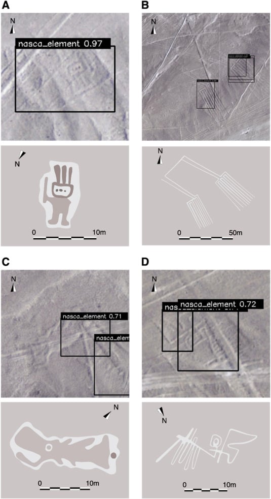
Researchers from Japan’s Yamagata University have used the technology to discovery four new Nazca geoglyphs in Peru. They were carved into the rugged landscape of modern-day southern Peru between 500 BCE and 500 C.E. by the ancient Nazca peoples. Numbering in the hundreds, they depict a myriad of creatures, real and fantastical, including killer whales, two-headed snakes, llamas, and curious humanoid figures.
The latest discoveries, which were published in July’s Journal of Archaeological Science, are an extension of work that Yamagata’s researchers began in 2016 (though initial surveys started in 2004). First, they used aerial photographs with a ground resolution of .1 meter per pixel to capture the entire area of the Nazca plateau, around 150 miles squared. Next, through a laborious process lasting five years, researchers identified geoglyphs manually, often checking their finds with onsite surveys. This last step has involved collaborating with IBM to empower A.I. to uncover the geoglyphs they’d missed in previous searches.
The four new Nazca geoglyphs found using A.I. in Peru. Image: Journal of Archaeological Science.
The newest Nazca geoglyphs show a humanoid figure holding a club, a wide-mouthed fish, a 255-foot-long pair of legs, and a bird (skeletal and abstract in an almost Alex Calder-like way).
“Our approach allows DL [Deep Learning] to learn representations of images with better generalization performance, enabling the discovery of targets that have been difficult to find in the past,” the researchers wrote in the paper. “Our method contributes to archaeology by establishing a new paradigm that combines field surveys and AI, leading to more efficient and effective investigations.”
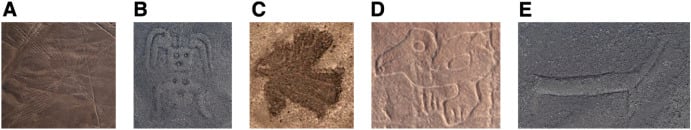
Geoglyphs can be categorized into three main types: figurative, geometric, and lineal. Image: Journal of Archaeological Science.
The researchers believe using A.I. to identify new geoglyph candidates is 21 times faster than the previous method of using the naked eye. Given Yamagata University’s most recent investigation focused on a limited northern area of the Nazca plateau, expect its machine learning models to make further discoveries in the near future.
The Nazca geoglyphs were first found by Peruvian archaeologist Toribio Mejia Xesspe in 1927 and received renewed academic attention in the 1980s. In 1993, the Nazca geoglyphs were registered as a UNESCO World Cultural Heritage Site.
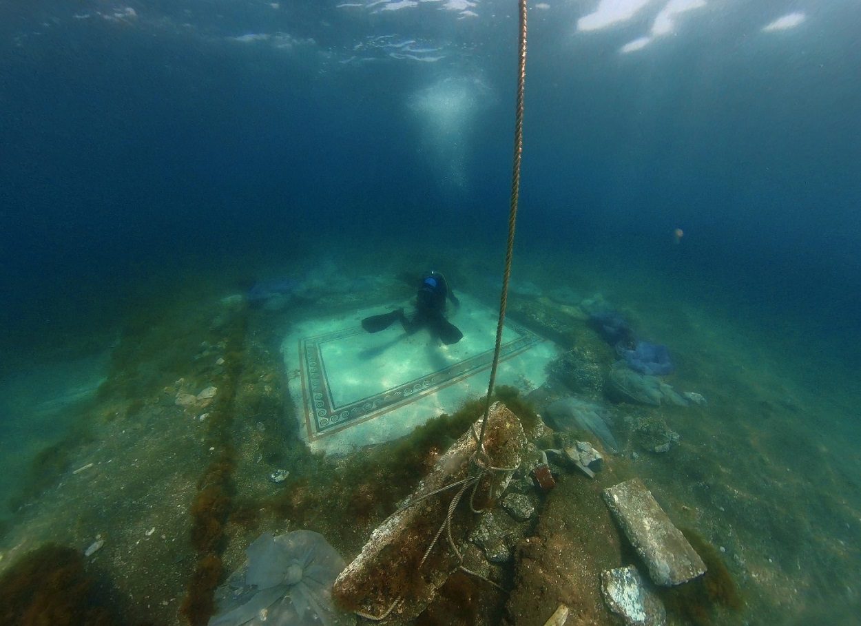
UNDERWATER ARCHAEOLOGISTS CONDUCT RESTORATION WORKS OF SUBMERGED ROMAN MOSAIC
UNDERWATER ARCHAEOLOGISTS FROM THE CSR RESTAURO BENI CULTURALI ARE CONDUCTING RESTORATION WORKS OF A RECENTLY REDISCOVERED MOSAIC IN THE SUBMERGED REMAINS OF ROMAN BAIA.
Baiae is an archaeological park consisting of a partially sunken town from the Roman period, located on the shore of the Gulf of Naples in the present-day comune of Bacoli in Italy.
Baiae developed into a popular Roman resort which was visited frequently by many notable Roman figures. The town would never attain a municipal status, but instead gained a reputation for a hedonistic lifestyle. This is supported by an account by Sextus Propertius, a poet of the Augustan age during the 1st century BC, who wrote that Baiae was a “vortex of luxury” and a “harbour of vice”.
Due to the position of the town on the Cumaean Peninsula in the Phlegraean Fields, an active and volatile volcanic region, local volcanic bradyseismic activity raised and lowered the geology on the peninsula that resulted in the lower parts of the town being submerged.
The mosaic, known as the “mosaic of the waves”, was first discovered over 40 years, but due to sediment changes on the seabed, its location was lost until an announcement of its rediscovery by the Campi Flegrei Archaeological Park in January 2023.
The mosaic would have been part of a high-status building in the Portus Julius area of Baiae and shows a pattern of waves surrounded by borders of pink and black tesserae on a white background.
Underwater archaeologists from the CSR Restauro Beni Culturali are currently removing incrustations from the mosaic and repairing missing tessera by using coloured mortar to match the colour of the original tiles.
The Campi Flegrei Archaeological Park intends for the mosaic to be an underwater attraction after restoration works have completed. The park is a protected area established in 2002 as a unique example in the Mediterranean of archaeological and natural protection underwater.
Giovanni da Verrazzano 1529 World Map displays almost all of the lands of the Old World and New World and yet he only explored the eastern coast of North America from Newfoundland/Nova Scotia to North Carolina. It's apparent however that Giovanni da Verrazzano had access to several older source maps from several explorers and cartographers from previous expeditions. He may have had access to maps from explorers and cartographers that were contemporaneous to his voyage to the New World also. Here's a map of the route taken by Estevan Gomez, a Portuguese explorer and cartographer, who sailed for the country Spain from 1524 to 1525.
Spanish ship captain Estevan Gomez explores the east coast of North America – from Nova Scotia to Florida – leading a 29-men, single-ship expedition in search for a northwest passage to the Spice Islands, and ends up as the namesake northeast America. Gomez (or Estêvão Gomes) is a Portuguese navigator and cartographer who sails for Spain. While searching for a waterway across North America, he enters every bay and river along the way. And while never finding the long-sought passage, Gomez charts the entire American east coast. Based on his charts, European mapmakers create the most accurate maps of North America (to date) and call the entire Northeast "La Tierra de Estevan Gomez." How many Americans in the Northeast know that they live in "The Land of Estevan Gomez?" When they see the Hudson River, how many New Yorkers know that Gomez first named it "El Rio San Antonio?" It all starts when, while in prison for deserting the Ferdinand Magellan expedition around the world, Gomez convinces King Charles V that he can find a faster and safer ride to the Indies than the treacherous route around the tip of South America, where he had deserted Magellan three years earlier. In a rush to beat France to find the passage, King Charles V releases Gomez from prison and gives him a chance to prove himself in a new expedition. Sponsorship for this better route to the Spice Islands means the creation of a new 50-ton caravel calledNuestraSeñoradelaAnunciada. With financial backing from the king, the budget allows for a crew of 29, including Gomez and 28 others (mostly Basque fishermen) to join the voyage. La Anunciada sails from La Coruña, Spain, to Nova Scotia, where Gomez gets tired of waiting for warmer weather and decides to head southwest to try to escape the cold. His ship sails along the east coast from Nova Scotia to the Penobscot River in Maine and to New York harbor, where Gomez finds the mouth of a great river he calls “El Rio San Antonio,” later to be renamed “Hudson.” After 10 months and 27 days checking rivers, bays and all waterways that could possibly cross North America from the Atlantic to the Pacific, Gomez gives up the search for the mythical northwest passage and decides to return to Spain. Yet, before returning home, to offset the cost of his unaccomplished journey, Gomez abducts 50 Native Americans to be used for slave trading. But once back in Spain, this is seen as foolish idea by King Charles V, who forces Gomez to release the slaves he is planning to sell. Although he does not find the northwest passage, and makes a foolish mistake on his way home, Gomez gives Europe the most accurate map of the east coast of North America. In 1529, using Gomez’s charts, celebrity Portuguese cartographer Diogo Ribeiro creates a detailed map of the New World and calls northeast North America, “Tierra de Estevan Gomez.” And that map is used in Europe for many years.